Jhalandhar, a bustling city in Punjab, India, is known for its rich cultural heritage and rapid urbanization. With a growing population and increasing traffic, maintaining the city's road infrastructure had become a challenging endeavor. Manual road inspections struggled to keep up with the extensive road network, leading to delays in maintenance and safety concerns.

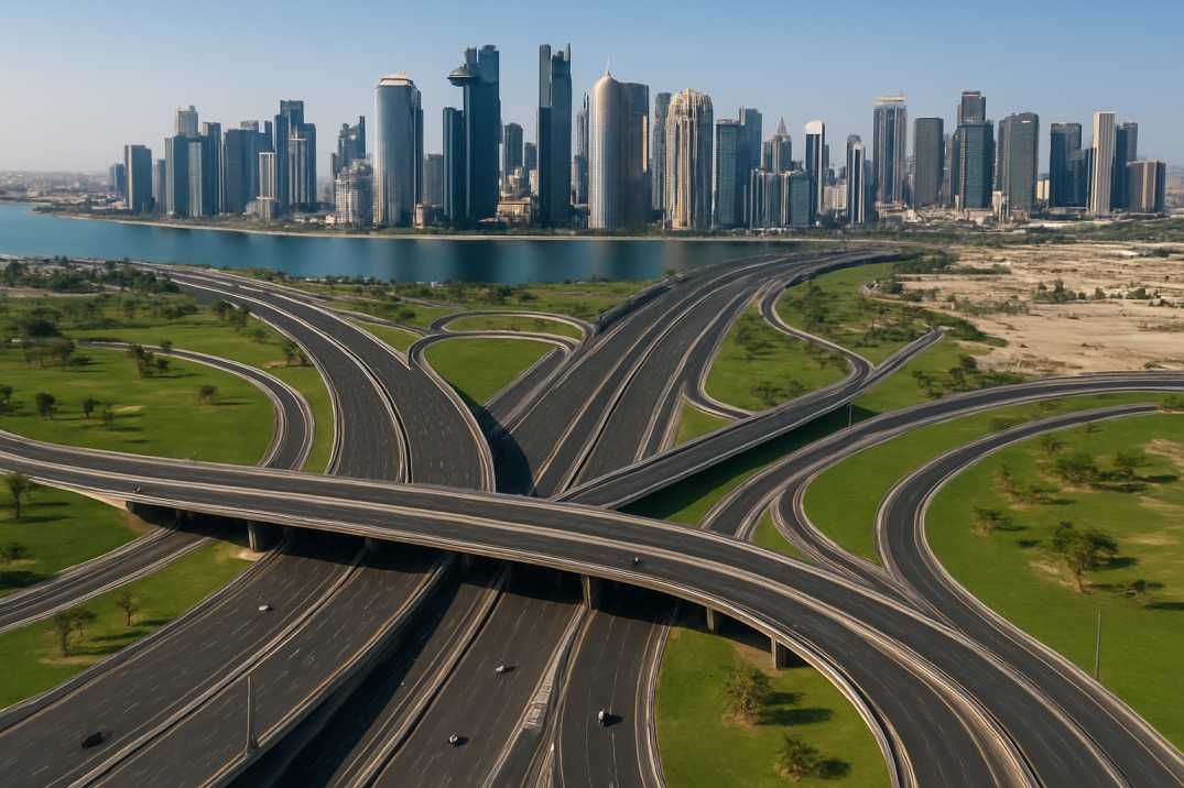
Jalandhar's urban expansion has given rise to a sprawling road network that weaves through its energetic streets. Covering more than 200 kilometers, these roads thread through the city, connecting its neighborhoods, businesses, and institutions. As the city's population surges and economic activities diversify, the role of well-maintained roads becomes pivotal, ensuring efficient traffic flow, safe commutes, and sustainable urban progress.
Nonetheless, managing and preserving this extensive road infrastructure presents an intricate challenge. The conventional method of manual inspections, constrained by time and human limitations, struggles to address the city's road management needs. It is within this intricate urban fabric that the narrative of Jalandhar's road management transformation through RoadVision AI comes to life.
The pilot program aims to validate RoadVision AI's effectiveness in transforming road infrastructure management. It seeks to assess the solution's accuracy in identifying road distresses, evaluate its performance in real-world conditions, and demonstrate its potential to enhance road maintenance, safety, and budget optimization.
At the heart of RoadVision AI's success lies its ability to harness a wealth of data and convert it into actionable insights. In the case of Smart City Jalandhar, the solution embarked on a paid pilot covering an impressive 200 kilometers of roads. Through a synergy of cutting-edge technologies, including AI and Geographic Information Systems (GIS), RoadVision AI created digital twins of the road network. These virtual replicas served as dynamic models, capturing real-world road conditions, layouts, and attributes. The survey of the road was done by providing the necessary smartphone infrastructure including the RoadVision AI Data collection App and suction mount to be attached on the windshield of the vehicle.

The pivotal test of any technological innovation lies in its real-world effectiveness. In Smart City Jalandhar, RoadVision AI demonstrated its prowess by achieving a significant milestone—deliverables for 200 kilometers of road were accepted. This achievement spoke volumes about the solution's accuracy in identifying distress signs, such as potholes of varying severity, ravelling levels, settlements, and an array of cracks. The system's ability to categorize distress, whether it be moderate potholes or severe shoving, underscored its precision.

In the pursuit of efficient road infrastructure management, RoadVision AI's innovative approach transcends traditional methods. One remarkable facet of this approach is the road network segmentation with color-coded schemes, offering a visual representation of distress severity. This nuanced system captures and categorizes an array of road distresses, empowering decision-makers with a holistic perspective.

Imagine a road network transformed into a canvas of color, each hue representing a distinct level of distress severity. RoadVision AI's segmentation employs this intuitive approach to communicate the urgency of interventions. Including potholes, rutting, patching, alligator crack, transverse crack, longitudinal crack, ravelling and settlements, each distress type is color-coded according to its severity, enabling stakeholders to grasp the situation swiftly and effectively. The classification of these distress have been as per IRC guidelines and other road regulatory authorities which governs similar domain across other countries.

RoadVision AI exemplifies how the integration of AI, GIS, and data-driven insights transforms road management, prioritises timely road maintenance, early defect detection, budget calculation tool, AI insights. By overcoming challenges, the solution ushers in a new era of efficient, proactive, and informed road infrastructure management.
The Autonomous Road Engineer
AI that is transforming road infrastructure, from reactive to predictive.