Canada's road network—spanning from the Atlantic to the Arctic—is exposed to some of the harshest operating conditions in the world. Extreme temperature swings, freeze–thaw cycles, heavy truck traffic, and long winter seasons accelerate pavement deterioration. These conditions make pavement distress a critical issue for transportation agencies, municipalities, and engineering teams.
Guidelines from the Transportation Association of Canada (TAC) and infrastructure initiatives under Transport Canada emphasize structured pavement assessment and proactive maintenance. Yet, traditional pavement monitoring methods often fall short in a country as vast and climate-diverse as Canada.
As the saying goes, "An ounce of prevention is worth a pound of cure." For Canadian roads, early detection—especially through AI-powered road asset management—can prevent costly failures and extend pavement lifespan.
Several factors amplify the urgency for modernizing pavement condition monitoring in Canada:
Traditional manual surveys and PCI-based inspections are time-consuming, subjective, and unable to consistently detect early-stage deterioration across Canada's vast network.
AI-based road asset management solves these gaps by enabling scalable, uniform, and accurate inspection—even in remote northern regions where manual surveys are logistically challenging.
Although Canadian agencies follow TAC guidance, several pavement engineering principles parallel those found in international frameworks. These core principles support reliable distress evaluation and effective asset management:
2.1 Distress Identification and Classification
Both TAC and international methodologies require the systematic identification and categorization of pavement defects—cracks, rutting, raveling, potholes, and structural failures—using standardized protocols.
2.2 Severity Assessment and Quantification
Marking distress type alone isn't sufficient. Engineers must quantify severity, extent, and progression—critical inputs for maintenance planning and budget forecasting.
2.3 Surface and Structural Condition Integration
Condition ratings should reflect both surface health and subsurface stability, ensuring comprehensive lifecycle management that prevents premature failure.
2.4 Data-Driven Maintenance Planning
Modern pavement management emphasizes predictive modeling, preservation strategies, and lifecycle cost optimization rather than reactive emergency repairs.
2.5 Consistent and Frequent Monitoring
Given rapid pavement deterioration during Canada's winters, frequent assessments help prevent small defects from evolving into major failures requiring expensive reconstruction.
These principles align closely with what AI-enabled platforms like RoadVision AI are designed to automate and enhance.
3.1 Pavement Cracks
Cracking is the most widespread distress across Canadian roads, often worsened by freeze–thaw expansion and contraction that opens and widens fissures with each temperature cycle.
Types include:
These are especially common in provinces like Ontario, Alberta, Quebec, Manitoba, and the Northern territories where temperature extremes are most severe.
3.2 Rutting
Wheel-path depressions from material consolidation or lateral movement, exacerbated by:
Rutting increases hydroplaning risks during spring thaw and reduces ride quality significantly.
3.3 Potholes
A notorious Canadian winter and spring issue. Moisture infiltration combined with freeze–thaw expansion and traffic loading creates a cycle of deterioration that rapidly forms potholes. They damage vehicles, create safety hazards, and drive up maintenance costs for municipalities nationwide.
3.4 Raveling
Surface disintegration where aggregates detach from asphalt binder, caused by:
This reduces skid resistance and increases surface texture depth, accelerating further deterioration.
3.5 Shoving and Corrugation
Wave-like deformations at intersections, hills, or areas with repeated braking. Unstable mixes, inadequate compaction, or excessive moisture often cause these issues, creating uncomfortable and potentially dangerous driving conditions.
3.6 Frost Heave
Unique to cold climates, frost heave occurs when ice lenses form in the subgrade, causing differential uplift that damages pavement structure. This is particularly common in areas with frost-susceptible soils and poor drainage.
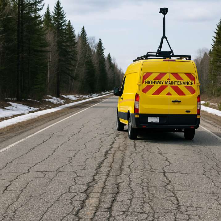
AI-powered pavement condition monitoring enables Canadian transportation agencies to meet TAC-aligned standards more efficiently through the Pavement Condition Intelligence Agent.
4.1 Automated Crack Detection
RoadVision AI identifies and classifies cracks using machine learning trained on millions of road images captured across diverse Canadian conditions. This ensures objective, consistent detection even under varying weather or lighting conditions—from bright summer sun to overcast winter skies.
4.2 Distortion and Rutting Analysis
Using depth estimation and image-based profiling, the system detects wheel-path depressions and quantifies rut depth with millimetre-level accuracy—critical for high-volume corridors like the 401 in Ontario or the Trans-Canada Highway.
4.3 Pothole Detection and Formation Prediction
The platform identifies existing potholes and, more importantly, detects precursor conditions that indicate where potholes will form after the next freeze–thaw cycle, enabling preventive intervention.
4.4 PCI Automation and Digital Condition Scoring
RoadVision AI digitizes pavement distress data and automatically computes Pavement Condition Index (PCI) scores, integrating geolocation, severity, and extent into standardized formats compatible with Canadian asset management systems.
4.5 GIS-Based Road Inventory Integration
The Roadside Assets Inventory Agent links pavement condition with roadside assets—signs, culverts, guardrails, drainage structures—creating a complete digital twin of the roadway network for holistic management.
4.6 Traffic-Driven Pavement Performance Insights
By integrating traffic counts and axle loads from the Traffic Analysis Agent, RoadVision AI correlates distress intensity with freight movement patterns, enabling data-backed prioritization of rehabilitation and capital planning.
4.7 Freeze-Thaw Impact Analysis
The platform tracks deterioration patterns across seasons, identifying segments most vulnerable to freeze-thaw damage and predicting accelerated failure zones before they become critical.
Even with established TAC guidelines, agencies still face significant hurdles:
As Canadians say, "Fixing the roof in summer is better than patching it in winter." AI helps agencies act before damage escalates.
Canadian road networks are under immense pressure—from harsh winters to heavy transport loads. Manual inspections alone can't keep pace with the scale or speed of deterioration. AI-driven pavement assessment is no longer a luxury; it's a necessity for sustainable, climate-resilient infrastructure.
RoadVision AI leverages computer vision, digital twins, and predictive analytics through the Pavement Condition Intelligence Agent to detect cracks, potholes, rutting, and surface defects early—giving engineers the clarity and lead time they need. Fully aligned with Canadian transportation standards and engineering requirements, the platform empowers agencies to:
In short, it helps agencies "stay ahead of the curve"—literally and figuratively—by predicting failures before they occur.
If your city, ministry, or transportation department wants to transform its pavement management strategy, book a demo with RoadVision AI today and take the first step toward smart, resilient, and future-ready road networks.
Q1. What is the most common pavement distress in Canada?
The most common types are longitudinal and transverse cracks, followed by rutting and potholes, especially in freeze-thaw regions.
Q2. How accurate is AI in detecting pavement cracks?
AI models can detect and classify cracks with over 90% accuracy using computer vision and deep learning.
Q3. Is PCI still used if AI is adopted?
Yes, AI systems like RoadVision enhance and automate PCI reporting, not replace it, making condition monitoring more scalable and objective.

The Autonomous Road Engineer
AI that is transforming road infrastructure, from reactive to predictive.
.webp)
.webp)
.png)