Flooding remains one of the most disruptive and financially damaging natural hazards affecting transport networks across Victoria. With climate change intensifying rainfall patterns, local councils and state authorities face increasing pressure to protect road assets from sudden inundation, shoulder collapses, pavement deterioration and overloaded drainage systems. Traditional monitoring methods often fall short when adverse weather makes access unsafe or slows down inspections.
Today, AI-driven road monitoring systems are redefining how Victorian agencies manage road resilience. Powered by computer vision, machine learning and high-resolution imaging, modern road asset management Australia platforms can identify flood-prone segments, assess surface degradation and map emerging hazards long before structural failures occur. Companies like RoadVision AI are bringing a new level of speed, accuracy and continuity to infrastructure oversight—proving that forewarned is forearmed.
Regions such as Gippsland, the North-East, and corridors along the Murray River experience recurring flood events that place immense strain on pavements, culverts and drainage systems. Even roads built to arterial standards face challenges including:
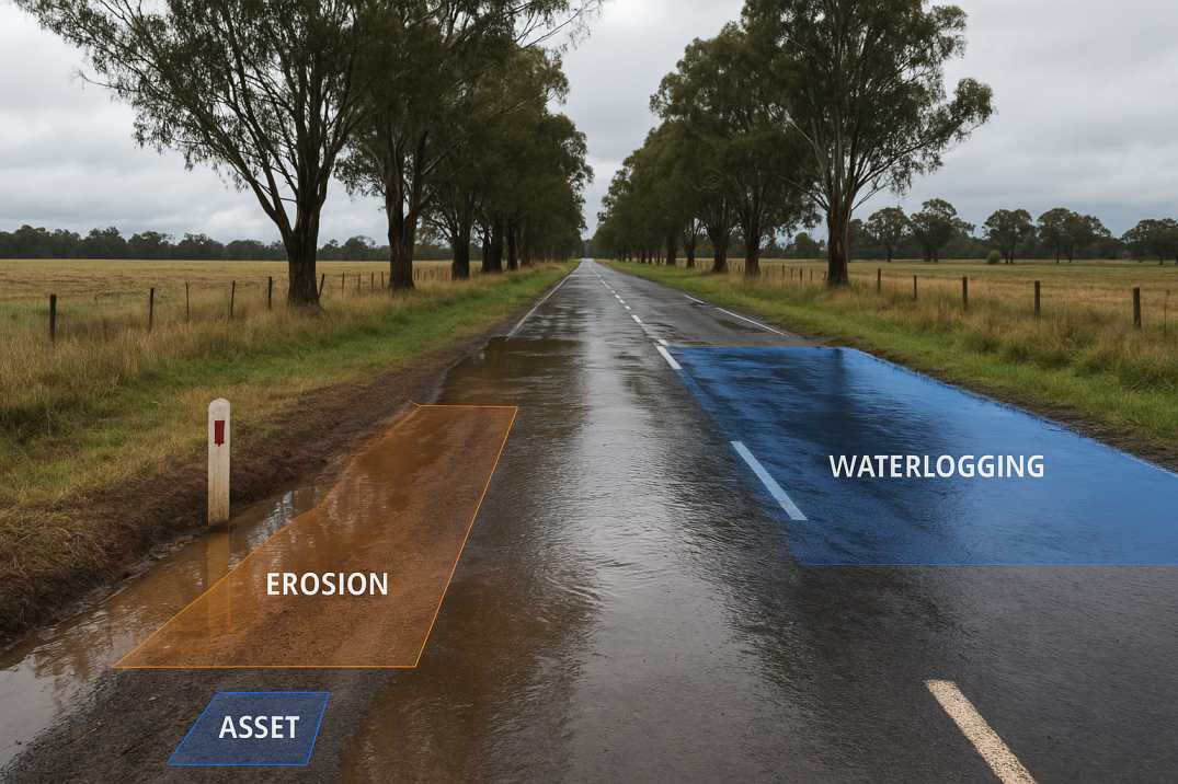
Manual inspections often cannot keep up with damage that evolves within hours. AI-based flood risk assessment tools through the Pavement Condition Intelligence Agent enable authorities to continuously monitor vulnerable networks, converting real-world imagery into measurable indicators of structural distress. Integrating these insights with digital asset registries via the Roadside Assets Inventory Agent allows engineers to understand deterioration patterns, identify assets near waterways and plan long-term reconstruction with greater confidence.
2.1 Immediate Flood Impacts
2.2 Delayed Impacts
2.3 Long-Term Impacts
While India's IRC frameworks are referenced widely in global asset management literature, flood-resilient road management in Victoria aligns more closely with Austroads and state emergency response principles. The essential principles include:
3.1 Early Detection of Water-Induced Damage
Agencies must identify pavement weakening, drainage blockage and erosion before they escalate—a challenge that AI through the Pavement Condition Intelligence Agent solves through continuous monitoring.
3.2 Integrated Drainage and Hydrological Assessment
Proper functioning of culverts, cross-drainage structures and surface water paths is critical to preventing long-term deterioration.
3.3 Structural and Geotechnical Stability Checks
Shoulder strength, subgrade condition, retaining structures and embankments must be evaluated regularly, especially after heavy rainfall.
3.4 Risk-Based Prioritisation
Maintenance and emergency works must be guided by vulnerability maps, asset importance and real-time flood behaviour.
3.5 Safe Accessibility and Reopening Protocols
Before corridors reopen, engineers must verify structural integrity and compliance with Austroads geometric and safety guidelines.
3.6 Climate Resilience Planning
Infrastructure must be designed and maintained with future flood risks in mind.
AI through the Road Safety Audit Agent supports each principle by providing measurable, repeatable and real-time data—turning complex field assessments into actionable intelligence.
4.1 Gippsland
4.2 North-East Victoria
4.3 Western Victoria
4.4 Metropolitan Melbourne
RoadVision AI applies AI to flood-resilient road monitoring through its integrated suite of AI agents, delivering comprehensive solutions for Victorian authorities.
5.1 Continuous AI-Powered Damage Detection
The Pavement Condition Intelligence Agent captures high-resolution video and sensor data through survey vehicles, drones and fixed cameras. Its AI engine classifies:
By converting every frame into structured datasets, the platform ensures that no developing hazard flies under the radar.
5.2 Automated Digital Road Inventory Mapping
The Roadside Assets Inventory Agent maps roadside assets such as:
This supports councils in maintaining accurate, dynamic asset registers—essential for post-flood recovery funding and planning.
5.3 AI-Enhanced Flood Risk Mapping
Using topography, rainfall histories and hydrological patterns, the platform produces flood vulnerability maps identifying:
These insights directly inform maintenance scheduling and resilience planning.
5.4 AI-Driven Post-Flood Assessment and Safety Verification
After floodwaters recede, RoadVision AI supports rapid corridor reopening by:
This allows engineers to make reopening decisions based on evidence, not assumptions—a vital safeguard when safety hangs in the balance.
5.5 Real-Time Water Level Monitoring
Integration with water level sensors enables:
5.6 Drainage Performance Monitoring
The Roadside Assets Inventory Agent tracks:
6.1 Austroads Guide to Road Design Part 5: Drainage
6.2 Austroads Guide to Asset Management
6.3 Victorian State Requirements
Despite the transformative benefits, agencies may face certain operational hurdles:
7.1 Weather-Limited Data Capture
Heavy rainfall, fog or standing water can reduce visibility for sensors, requiring multi-sensor workflows.
AI Solution: Multi-sensor fusion (visual, thermal, radar) through RoadVision AI maintains accuracy.
7.2 Integration With Legacy Systems
Local councils may rely on older GIS/CAD platforms that require integration bridges.
AI Solution: Flexible APIs enable gradual integration without disrupting current operations.
7.3 Skill Transition for Field Teams
Staff may need training to confidently interpret AI-generated datasets and analytics dashboards.
AI Solution: Comprehensive training programs ensure successful adoption.
7.4 Data Volume and Infrastructure
Continuous monitoring produces large datasets, requiring appropriate storage and processing capacity.
AI Solution: Cloud-based platforms through RoadVision AI manage data at scale.
7.5 Emergency Response Coordination
Post-flood assessment requires coordination with emergency services and multiple agencies.
AI Solution: Centralized platforms ensure all stakeholders work from the same data.
7.6 Funding for Resilience Works
Justifying investment in flood resilience requires objective condition data.
AI Solution: Data-driven evidence supports funding applications.
These challenges are manageable with phased implementation, training initiatives and hybrid data-capture strategies.
8.1 For Maintenance Teams
8.2 For Agencies
8.3 For Communities
Flood-prone Victorian regions can no longer rely solely on manual surveys or reactive maintenance. AI through the Pavement Condition Intelligence Agent and Roadside Assets Inventory Agent has become indispensable for continuous monitoring, rapid hazard detection and evidence-based asset management.
The platform's ability to:
transforms how flood-affected roads are managed across Victoria.
By offering automated condition assessment, predictive risk mapping and digital twin-based analysis through the Traffic Analysis Agent and Road Safety Audit Agent, RoadVision AI empowers authorities to reduce repair costs, minimise safety risks and enhance long-term infrastructure resilience.
In flood events—when every minute counts—AI ensures faster, more accurate decisions that protect communities, freight routes and critical road assets.
To discover how AI can strengthen your flood-resilience strategy, book a demo with RoadVision AI today and experience how intelligent monitoring can future-proof Victoria's road network.
AI-based remote sensing, drone imagery and fixed IoT systems allow monitoring even when roads cannot be physically reached.
For high-risk corridors, continuous monitoring or post-rainfall automated surveys are recommended.
Yes, AI generates vulnerability maps, deterioration forecasts and asset life-cycle insights essential for long-term capital planning.

The Autonomous Road Engineer
AI that is transforming road infrastructure, from reactive to predictive.
.webp)
.webp)
.png)