India's road network is expanding at an unprecedented pace, yet the complexity of managing traffic during road works has risen just as fast. Traditional diversion planning and signage placement still rely heavily on manual expertise—an approach that struggles to keep up with dynamic, high-density traffic environments. While the Indian Roads Congress provides a baseline through the IRC SP 55:2014 guideline, the reality on the ground demands smarter, faster, and more adaptive solutions.
And in today's world, where traffic patterns change "faster than you can blink," AI-powered road management is no longer a luxury—it is a necessity.
The IRC SP 55:2014 guideline standardises temporary traffic control devices, signage placement, barricading, and diversion design during road works. While essential, it is fundamentally static. It does not evolve in real-time, nor does it incorporate the contextual nuances of modern traffic behaviour.
Key limitations include:
As traffic density increases and urban mobility becomes more complex, depending only on conventional compliance is like "bringing a knife to a gunfight." The stakes are too high, and the variables too many.
The core principles of the IRC SP 55:2014 guideline revolve around:
Additionally, guidelines such as IRC:82-2015 emphasise early detection of pavement defects and timely preventive maintenance—both key contributors to safer work zones and predictable diversion planning.
However, these principles were crafted for a manual environment. The next leap is to augment them with AI, not replace them.
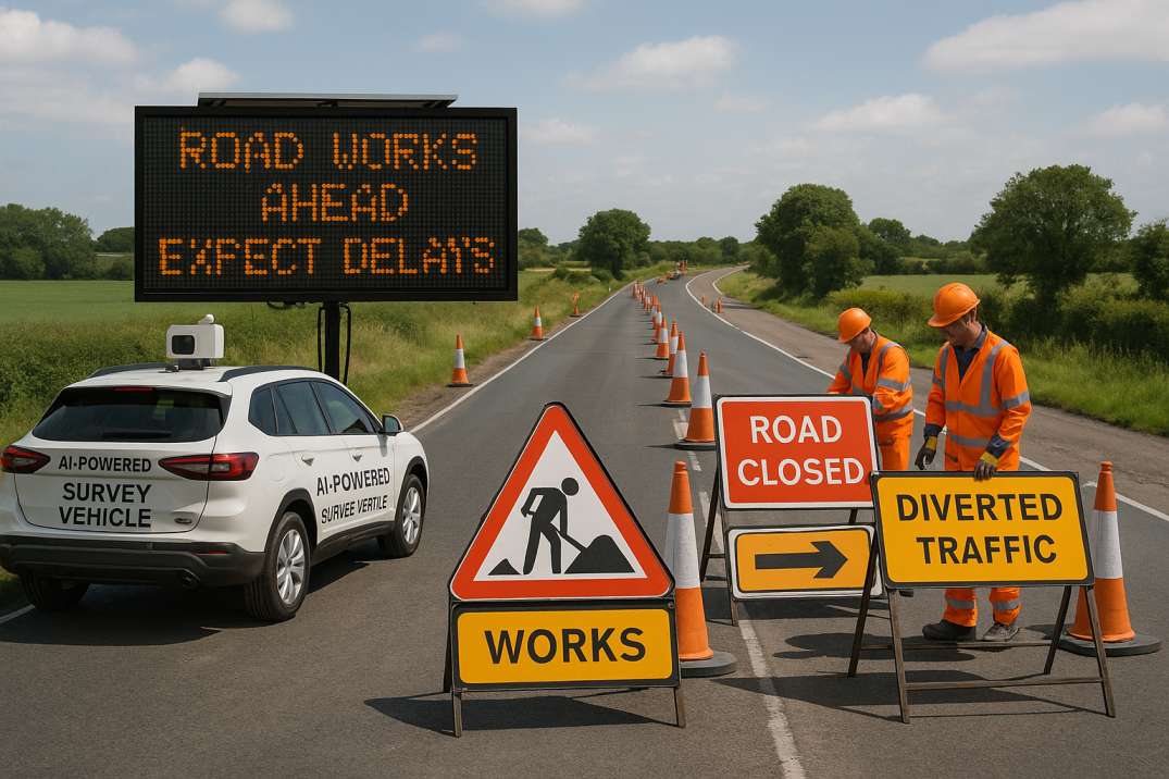
Platforms like RoadVision AI are redefining how India approaches road safety, road asset management, and diversion planning. By integrating computer vision, high-resolution imaging, GPS, LiDAR, and digital twin technology through the Road Safety Audit Agent and Traffic Analysis Agent, AI enhances every step of the process.
3.1 Intelligent Data Collection
Smart survey vehicles capture images, sensor readings, pavement conditions, signage visibility gaps, and shoulder defects with near-perfect accuracy during normal traffic flow—no dedicated surveys required.
3.2 Contextual Risk Mapping
AI fuses multiple data sources to create granular risk heat maps:
This multi-dimensional analysis reveals risks that manual audits simply cannot detect.
3.3 Diversion Simulation
Before a single cone is placed on the road, AI simulates:
This allows planners to test multiple diversion options virtually and pick the safest, most efficient one before implementation.
3.4 Optimised Signage Planning
The Roadside Assets Inventory Agent analyses site conditions to recommend:
This ensures compliance and usability—because a sign is useful only if drivers can perceive and process it in time.
3.5 Real-Time Monitoring & Compliance Validation
After deployment, AI continuously evaluates:
Any deviation from IRC SP 55 norms is flagged instantly, enabling corrective action without delay and creating an audit trail for accountability.
3.6 Integration with Pavement Condition
The Pavement Condition Intelligence Agent ensures that diversion routes themselves are assessed for pavement health, preventing the irony of diverting traffic onto roads that are themselves unsafe or deteriorating.
This transforms compliance from a "tick-box exercise" into a performance-driven safety framework.
Despite the clear benefits, several challenges remain:
Yet, as the proverb goes, "A journey of a thousand miles begins with a single step." India has taken that step—and platforms like RoadVision AI are accelerating the momentum through offline-capable solutions, intuitive interfaces, and scalable deployment models.
India's road sector is standing at a pivotal moment. Sticking solely to traditional methods—no matter how reliable they once were—is no longer enough. AI-driven platforms are enabling smarter, safer, and more future-ready road management that goes beyond mere compliance.
RoadVision AI leverages the power of AI and computer vision through its integrated suite to:
Through the Road Safety Audit Agent, Traffic Analysis Agent, Pavement Condition Intelligence Agent, and Roadside Assets Inventory Agent, RoadVision AI delivers comprehensive intelligence for diversion and signage planning.
As the saying goes, "Forewarned is forearmed." With AI, planners are finally equipped with foresight—allowing them to design diversions and signage layouts that adapt, anticipate, and protect.
If you want diversions that don't just guide traffic but think ahead, now is the time to embrace intelligent road management solutions. Book a demo with RoadVision AI today and discover how AI can transform your approach to work zone safety and compliance.
Q1. Is IRC SP 55 still relevant with AI systems?
Yes, IRC SP 55 sets the regulatory foundation. AI enhances compliance and updates it in real time based on actual road usage data.
Q2. How does AI help in work zone safety?
AI maps risks, simulates traffic flows, and suggests precise signage plans, improving safety for both workers and drivers.
Q3. Can AI systems work in rural road environments?
Absolutely. With satellite and edge data capture, AI can function even in low-connectivity regions.

The Autonomous Road Engineer
AI that is transforming road infrastructure, from reactive to predictive.

.webp)