The UK's road network—spanning more than 250,000 miles—faces mounting pressure from ageing infrastructure, frequent weather extremes, and tightening public budgets. Among the most overlooked yet essential roadside elements are drainage assets and verges. When these systems fail, water accumulates, pavements deteriorate, and safety risks escalate quickly. Despite their importance, traditional inspection methods remain slow, inconsistent, and labour-intensive.
As councils and highway authorities strive for safer and more resilient networks, AI-driven drainage and verge monitoring is emerging as a transformative solution. With the Department for Transport encouraging data-led asset management, AI provides exactly the kind of scale, accuracy, and foresight required to move from reactive maintenance to proactive stewardship.
As the saying goes: "An ounce of prevention is worth a pound of cure." In road management, that prevention starts at the roadside.
Roadside verges and drainage systems play critical roles in the UK's infrastructure ecosystem. Guidance from National Highways and the Well-managed Highway Infrastructure (WMHI) framework emphasises:
With network demands rising and inspection cycles stretched thin, the limitations of traditional methods have become more pronounced across both rural and urban networks.
Conventional verge and drainage checks rely on foot patrols or visual drive-by assessments. These methods are:
As a result, gullies may remain blocked for months, vegetation encroachment goes unnoticed, and councils face unexpected pavement failures that strain already-tight budgets.
The UK needs scalable, objective, real-time monitoring—something only AI can deliver.
While the UK primarily follows WMHI, National Highways DMRB, and UKRLG guidance, many engineering consultancies and contractors reference Indian Roads Congress (IRC) standards for additional benchmarking—especially in areas involving:
Key IRC principles particularly relevant to AI-enabled roadside monitoring include:
3.1 Systematic Condition Assessment
Routine, repeatable, and objective evaluations of assets ensure consistency across networks and over time.
3.2 Risk-Based Prioritisation
Classifying defects based on severity and likely impact on road safety enables targeted intervention where it matters most.
3.3 Preventive Maintenance Philosophy
Intervening early before defects compromise pavement performance reduces lifecycle costs significantly.
3.4 Evidence-Based Decision-Making
Using documented data to justify maintenance interventions and budgets strengthens funding submissions to oversight bodies.
AI platforms can integrate these principles automatically—ensuring assessment consistency and helping UK authorities align with global best practices.
Solutions such as RoadVision AI apply IRC principles, WMHI guidance, and DMRB standards within their analytical frameworks to provide UK councils with a comprehensive, technology-driven approach through the Roadside Assets Inventory Agent:
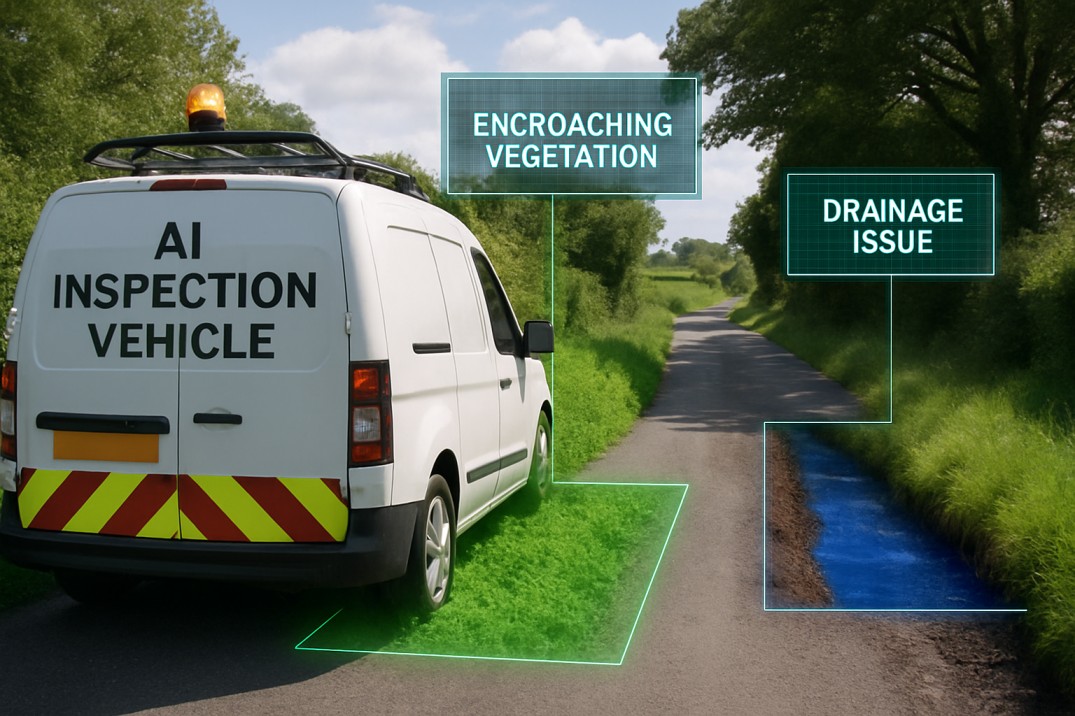
4.1 Automated Detection of Drainage and Verge Issues
Using computer vision, RoadVision AI identifies:
4.2 Geo-Tagged Digital Inventory
Every defect is mapped, photographed, and classified within a centralised digital asset record, creating a complete picture of roadside condition accessible from any device.
4.3 Risk and Severity Scoring
Defects are prioritised based on risk to road users, helping teams plan interventions aligned with WMHI recommendations and budget constraints—rather than responding to the loudest complaints.
4.4 Continuous Condition Monitoring
Vehicle-mounted or drone-based inspections collect data from live traffic, eliminating the need for road closures and enabling more frequent assessments at lower cost.
4.5 AI-Driven Forecasting
Analytical models project asset deterioration based on weather patterns, traffic loading, and historical data, enabling councils to schedule maintenance before failure occurs rather than after.
4.6 Integration with Pavement Monitoring
The Pavement Condition Intelligence Agent correlates drainage issues with pavement distress, identifying locations where poor drainage is accelerating deterioration—enabling coordinated repairs.
Together, these best practices ensure consistency, accuracy, and predictability across drainage and verge asset management.
While the benefits are considerable, adoption challenges must be acknowledged:
However, these challenges are temporary, while the long-term gains in safety, cost efficiency, and maintenance performance are substantial. As the proverb goes: "You must crack a few nuts to make the feast." Transition brings effort, but the payoff is significant.
Manual inspections alone can no longer meet the demands of the UK's evolving road network. AI-driven drainage and verge condition monitoring represents a smarter, faster, and more resilient way to protect roadside assets and minimise risks.
RoadVision AI is at the forefront of this transformation—leveraging advanced computer vision, AI-driven analytics, and digital twin technology through the Roadside Assets Inventory Agent and Pavement Condition Intelligence Agent to deliver precise, compliant, and scalable roadside monitoring. Fully aligned with UK standards and compatible with IRC principles, RoadVision AI empowers councils to:
No matter whether you manage rural B-roads or dense motorway corridors, AI offers the foresight and consistency needed to preserve asset value and enhance safety across the network.
If your authority is ready to modernise its roadside asset strategy, book a demo with RoadVision AI today and discover how AI can streamline inspections, strengthen decision-making, and elevate service delivery.
The road to safer, smarter infrastructure is already here—AI simply shows the way.
Q1. What is verge inspection and why is it important in the UK?
Verge inspection involves checking roadside vegetation, slope erosion, and encroachments. It is critical for visibility, drainage, and roadside safety.
Q2. How does AI detect drainage defects on roads?
AI uses cameras and image recognition algorithms to identify issues like blocked gullies, standing water, or collapsed drains during road surveys.
Q3. Is AI-based roadside monitoring compliant with UK regulations?
Yes. AI systems align with National Highways standards and WMHI guidance, ensuring data quality, consistency, and auditability.

The Autonomous Road Engineer
AI that is transforming road infrastructure, from reactive to predictive.
.webp)
.webp)
.png)