Urban mobility in Canada is evolving rapidly as cities prioritise road safety, sustainable transport and data-driven planning. With increasing pedestrian and cyclist activity across major urban corridors, there is growing demand for accurate, continuous and scalable monitoring solutions.
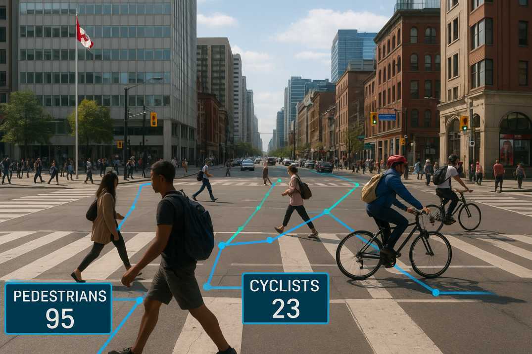
Modern road asset management in Canada, combined with Vision AI-based pedestrian and cyclist tracking, is enabling authorities to understand non-motorised road user behaviour with unprecedented precision. Through automated pedestrian counting and AI-driven traffic surveys, Canadian urban centres are transforming how active transportation data is collected, analysed and applied.
Traditional manual surveys often fail to capture real behavioural patterns. In contrast, AI-powered monitoring through the Traffic Analysis Agent delivers continuous, objective and regulation-aligned insights that support safer, more inclusive street design.
Canadian transportation planning places strong emphasis on Vision Zero principles, active transportation strategies and complete street design. Pedestrians and cyclists remain among the most vulnerable road users, particularly in dense downtown areas, school zones and transit corridors.
Accurate monitoring is essential to:
As Canadian guidelines increasingly encourage evidence-based decision making, automated monitoring through the Traffic Analysis Agent and Road Safety Audit Agent has become a critical component of modern mobility planning.
2.1 Key Urban Centers
2.2 Active Transportation Modes
2.3 High-Risk Locations
Conventional survey methods rely on manual counting, short-duration observations or static sensors. While useful, these approaches have major limitations in complex urban environments:
These gaps highlight the need for intelligent systems through RoadVision AI that operate continuously and adapt to dynamic city conditions.
Vision AI uses advanced computer vision and machine learning through the Traffic Analysis Agent to analyse video data captured from roadside cameras, mobile survey vehicles or fixed infrastructure.
These systems can identify, classify and track pedestrians and cyclists with high accuracy while maintaining privacy compliance.
Key capabilities include:
These insights move cities beyond basic counts toward behavioural intelligence that supports safer infrastructure design.
AI-based traffic data collection through the Traffic Analysis Agent enables municipalities to analyse active mobility patterns at scale. Vision AI systems process large datasets efficiently, delivering consistent insights across entire urban networks.
This supports:
When combined with automated road inventory inspection data from the Roadside Assets Inventory Agent, authorities gain a more complete picture of both infrastructure condition and user behaviour.
6.1 Volume Metrics
6.2 Safety Metrics
6.3 Behavioural Metrics
6.4 Infrastructure Metrics
AI-powered mobility monitoring through the Road Safety Audit Agent strengthens safety outcomes by identifying high-risk locations and conflict zones.
By correlating pedestrian and cyclist movement with traffic speeds, intersection geometry and signal timing, AI highlights where interventions are most urgently needed.
These insights directly support:
Such analytics are also valuable inputs for AI-based road safety audits, ensuring safety assessments reflect real-world usage patterns rather than assumptions.
Dedicated AI cyclist detection systems through the Traffic Analysis Agent accurately track bicycle movements even in mixed traffic conditions. These systems distinguish cyclists from pedestrians, vehicles and micromobility users, enabling more precise planning.
Applications include:
When combined with pavement insights from digital pavement condition surveys via the Pavement Condition Intelligence Agent, cities can ensure cycling infrastructure remains both safe and structurally reliable.
Modern automated traffic monitoring systems through the Traffic Analysis Agent integrate pedestrian, cyclist and vehicle data into unified dashboards. This integration strengthens road asset management in Canada by linking mobility demand with asset performance.
Benefits include:
10.1 Privacy Considerations
Video monitoring must balance safety benefits with privacy protections.
AI Solution: Anonymized data processing through RoadVision AI ensures privacy compliance.
10.2 Weather Variability
Snow, rain and low light affect camera visibility.
AI Solution: Adaptive algorithms maintain accuracy across conditions.
10.3 Infrastructure Integration
Legacy camera systems may need upgrades for AI processing.
AI Solution: Flexible integration enables gradual modernization.
10.4 Data Volume
Continuous monitoring generates large datasets requiring robust storage.
AI Solution: Cloud-based platforms manage data at scale.
10.5 Equity Considerations
Monitoring must ensure coverage across all neighbourhoods.
AI Solution: Equitable deployment strategies prioritise underserved areas.
Automated pedestrian and cyclist tracking using Vision AI through the Traffic Analysis Agent and Road Safety Audit Agent is redefining urban mobility management in Canada. By enabling continuous, accurate and scalable data collection, AI supports safer streets, smarter planning and more sustainable cities.
The platform's ability to:
transforms how active transportation is monitored across Canadian urban centres.
Through AI pedestrian tracking, automated pedestrian counting, AI-powered mobility monitoring and AI-based traffic data collection, Canadian urban centres can better protect vulnerable road users and design infrastructure that reflects how people actually move.
RoadVision AI is transforming infrastructure development and maintenance by harnessing advanced AI for roads. The platform enables early detection of potholes, cracks and surface defects through precise pavement surveys via the Pavement Condition Intelligence Agent, supporting timely maintenance and safer road environments.
Committed to building smarter, safer and more sustainable transport networks, RoadVision AI aligns with both IRC Codes and Canadian road engineering standards, empowering stakeholders with data-driven insights that reduce costs, mitigate risks and improve mobility outcomes through the Roadside Assets Inventory Agent.
To see how Vision AI can enhance pedestrian and cyclist monitoring for your city or project, book a demo with RoadVision AI today.
AI uses computer vision to detect, classify and track pedestrians from video data in real time.
Yes. Vision AI systems focus on movement patterns, not personal identification, ensuring privacy compliance.
Yes. Advanced models can accurately distinguish and analyse multiple road user types at once.

The Autonomous Road Engineer
AI that is transforming road infrastructure, from reactive to predictive.
.webp)
.webp)
.png)