The United States' transportation network is one of the largest and most heavily used in the world. From interstate highways to rural county roads, maintaining this vast system requires accurate, timely, and standardized road inventory data. As budgets tighten and travel demand grows, transportation agencies are realizing that traditional, manual inspection methods no longer cut it.
With aging infrastructure, rising maintenance costs, and increasing public expectations for safety and mobility, the need for data-driven, AI-powered road asset management has never been more urgent. As the saying goes, "You can't manage what you don't measure." Road inventory accuracy determines whether agencies can stay compliant, prioritize repairs, and stretch every taxpayer dollar effectively.
A road inventory captures comprehensive details about physical assets—pavement, markings, signage, guardrails, lighting, drainage systems, and more. For U.S. agencies, this information is essential for:
Under federal regulation, the Federal Highway Administration (FHWA) mandates that every state maintain current asset data, as outlined in 23 CFR Part 515, which governs Transportation Asset Management Plans (TAMPs). Additionally, reporting into the Highway Performance Monitoring System (HPMS) requires standardized inventory collection across all states.
Simply put, accurate road inventory is the backbone of effective and fiscally responsible transportation management.
While IRC (Indian Roads Congress) principles emphasize uniformity, safety compliance, and systematic asset management, the U.S. applies similar philosophies through FHWA and AASHTO frameworks. Key governing principles include:
2.1 Standardization of Asset Data
Just as IRC stresses uniformity across agencies, the U.S. relies on:
These ensure consistency in how roadway elements are captured, classified, and reported nationwide.
2.2 Condition-Based Maintenance Philosophy
Both IRC and U.S. frameworks encourage:
This ensures roads stay functional longer and agency budgets remain optimized.
2.3 Integration of Technology in Inspections
Modern infrastructure management in the U.S. emphasizes:
These mirror the IRC's push toward modernization and accuracy, emphasizing reliability over manual subjectivity.
The United States follows a set of mature best practices to ensure high-quality road inventory data. RoadVision AI's platform aligns with and enhances these practices using automation, AI, and advanced imaging technologies through its integrated suite of AI agents.
3.1 Standardized Data Models
Best Practice: Use FHWA-compliant models like MIRE and LRM to ensure data interoperability across jurisdictions and compatibility with federal reporting systems.
RoadVision AI Approach: The Roadside Assets Inventory Agent automatically structures all collected data into MIRE-compliant formats, ensuring seamless integration with state DOT repositories and HPMS reporting workflows.
3.2 Automated Data Collection Tools
Best Practice: Reduce manual surveying errors and subjective assessments through technology-enabled data capture.
RoadVision AI Approach:
This enables agencies to inspect 1,000+ miles faster and with near-zero subjectivity compared to manual methods.
3.3 Cloud-Based Asset Storage
Best Practice: Maintain accessible, secure centralized data that can be shared across departments and with external stakeholders.
RoadVision AI Approach: Provides secure cloud dashboards accessible to DOTs, counties, MPOs, and consultants—ensuring visibility across departments and eliminating data silos that plague traditional approaches.
3.4 Accurate Geolocation Tagging
Best Practice: Use GPS/GNSS-enabled mapping with sub-metre accuracy for precise asset location.
RoadVision AI Approach: High-precision location tagging integrated with road GIS mapping systems, enabling asset-level traceability for maintenance crews, emergency responders, and planning teams.
3.5 Routine Pavement Condition Surveys
Best Practice: Conduct surveys annually or biannually to track deterioration and plan interventions.
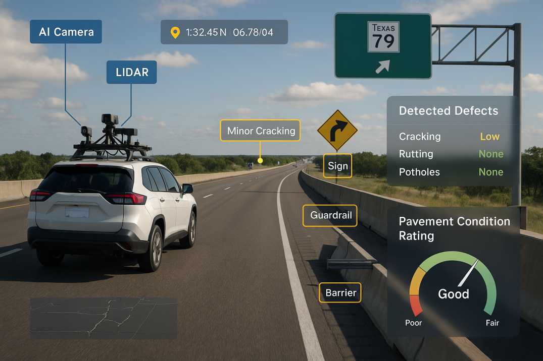
RoadVision AI Approach: The Pavement Condition Intelligence Agent enables rapid network-wide pavement surveys that identify cracks, rutting, raveling, potholes, and structural distress instantly—without dedicated survey vehicles or lane closures.
3.6 Integrated Road Safety Audits
Best Practice: Identify high-risk zones and blackspots through systematic safety assessments.
RoadVision AI Approach: The Road Safety Audit Agent provides AI-powered conflict detection, visibility analysis, and compliance checks with MUTCD standards for signage and markings.
3.7 Data-Driven Budgeting
Best Practice: Optimize funding allocation using evidence-based condition data and deterioration forecasts.
RoadVision AI Approach: Provides predictive analytics to help DOTs forecast deterioration, model intervention scenarios, and plan long-term budgets with confidence.
3.8 Combine Traffic and Inventory Data
Best Practice: Factor usage patterns into deterioration modeling for more accurate predictions.
RoadVision AI Approach: The Traffic Analysis Agent integrates AI-based traffic counts, speed studies, and classification surveys to map wear patterns and correlate asset condition with usage.
3.9 Digital Tools for Field Inspectors
Best Practice: Improve consistency between different inspection teams and reduce paperwork.
RoadVision AI Approach: Delivers mobile apps and dashboards enabling inspectors to validate AI findings, add field notes, and submit real-time observations—all linked to the central inventory.
3.10 Regular Data Audits
Best Practice: Ensure compliance and accuracy through systematic quality assurance.
RoadVision AI Approach: Automated anomaly detection flags inconsistent or missing data, while audit-ready asset logs and third-party validation workflows support quality control processes.
Even with modern tools, agencies face persistent challenges:
4.1 Vast Geographic Coverage
Millions of lane miles across diverse terrains require continuous monitoring—manual processes simply cannot scale to meet this demand without prohibitive costs.
4.2 Data Fragmentation Across Agencies
Cities, counties, MPOs, and state DOTs often store data in incompatible systems, creating barriers to regional analysis and coordinated planning.
4.3 Inconsistent Field Reporting
Human subjectivity leads to variability in condition ratings and classifications between different inspectors, districts, and time periods.
4.4 Limited Budgets for Comprehensive Surveys
Aging infrastructure demands more funding than agencies often receive, forcing trade-offs between survey frequency and network coverage.
4.5 Legacy Systems and Slow Modernization
Older asset management systems hamper progress toward integrated, real-time digital road management, creating technical debt that slows innovation.
4.6 Meeting Federal Deadlines
The September 30, 2026 deadline for MIRE Fundamental Data Elements collection creates urgency that traditional methods cannot satisfy.
As the saying goes, "A chain is only as strong as its weakest link." For many agencies, inconsistent or outdated data practices weaken their entire asset management strategy.
Modern road asset management in the USA requires precision, speed, and technological innovation. With traffic loads increasing and infrastructure aging, relying on outdated inspection practices is like "bringing a knife to a gunfight." AI-powered systems are no longer optional—they are essential for meeting federal requirements and public expectations.
RoadVision AI is redefining how agencies conduct road inventory inspections, pavement surveys, safety audits, and traffic analysis. By blending AI, computer vision, GIS mapping, and predictive analytics through the Roadside Assets Inventory Agent, Pavement Condition Intelligence Agent, Road Safety Audit Agent, and Traffic Analysis Agent, RoadVision AI helps organizations:
As the U.S. moves toward smarter infrastructure under the Bipartisan Infrastructure Law and other federal initiatives, the agencies that adopt automated, AI-driven inventory systems today will be the ones leading the nation tomorrow.
If your agency is ready to transform road inventory management with AI-powered intelligence, book a demo with RoadVision AI today and discover how our platform can help you meet MIRE requirements, optimize asset management, and build a future-ready transportation network.
Q1. What is the role of AI in road inventory data collection?
AI helps in automating defect detection, improving data accuracy, and reducing survey times through real-time image and pattern recognition.
Q2. How often should pavement condition surveys be conducted?
Most DOTs conduct pavement condition assessments annually or bi-annually to ensure timely maintenance and data accuracy.
Q3. Is GIS mapping mandatory for road inventory in the USA?
While not mandatory in every state, road GIS mapping USA is widely adopted as a best practice for spatial accuracy and infrastructure planning.

The Autonomous Road Engineer
AI that is transforming road infrastructure, from reactive to predictive.
.webp)
.webp)
.png)