Potholes have become a nationwide concern across South Africa, with an increasing impact on public safety, infrastructure spending, and economic productivity. The South African National Roads Agency (SANRAL) and local municipalities are overwhelmed with road repair backlogs. Traditional methods of identifying and fixing potholes are reactive, time-consuming, and cost-intensive.
In this context, a new frontier is emerging — AI-based road management systems. These systems leverage computer vision to automate pothole detection, optimize road maintenance, and empower governments and infrastructure developers with real-time insights.
As the saying goes, "A problem shared is a problem halved," but in South Africa's case, potholes seem to multiply faster than we can report them.
This mounting challenge has sparked an important question:
Can artificial intelligence and computer vision truly transform how South Africa detects, prioritizes, and repairs potholes?
The answer: Yes — and the transformation has already begun.

South Africa's road infrastructure spans urban metros, rural districts, provincial roads, national highways, and mining corridors — each with distinct load, weather, and maintenance pressures. Traditional inspection methods simply cannot keep up.
Key Reasons for Adopting AI-Based Road Management:
1.1 Massive Financial Losses
Pothole-related vehicle damage costs South Africans billions of Rands annually, affecting individuals, insurers, logistics companies, and local economies.
1.2 Slow and Labour-Intensive Inspections
Manual inspections require teams, time, logistics planning, and extensive manpower — often resulting in infrequent assessments that miss developing problems.
1.3 Ineffective Detection and Reporting
Damage often goes unnoticed for months. By the time repairs begin, the road has deteriorated even further, escalating costs exponentially.
1.4 Safety and Productivity Risks
Poor road conditions increase accident rates, slow freight movement, and hamper economic productivity across critical supply chains.
South Africa needs a proactive, scalable, data-driven maintenance system — not reactive fixes that address symptoms while ignoring root causes.
While India uses IRC standards, South Africa's governing guidelines include:
These standards emphasise:
AI-driven road management systems align perfectly with these principles by delivering continuous, objective, geo-referenced inspections at scale.
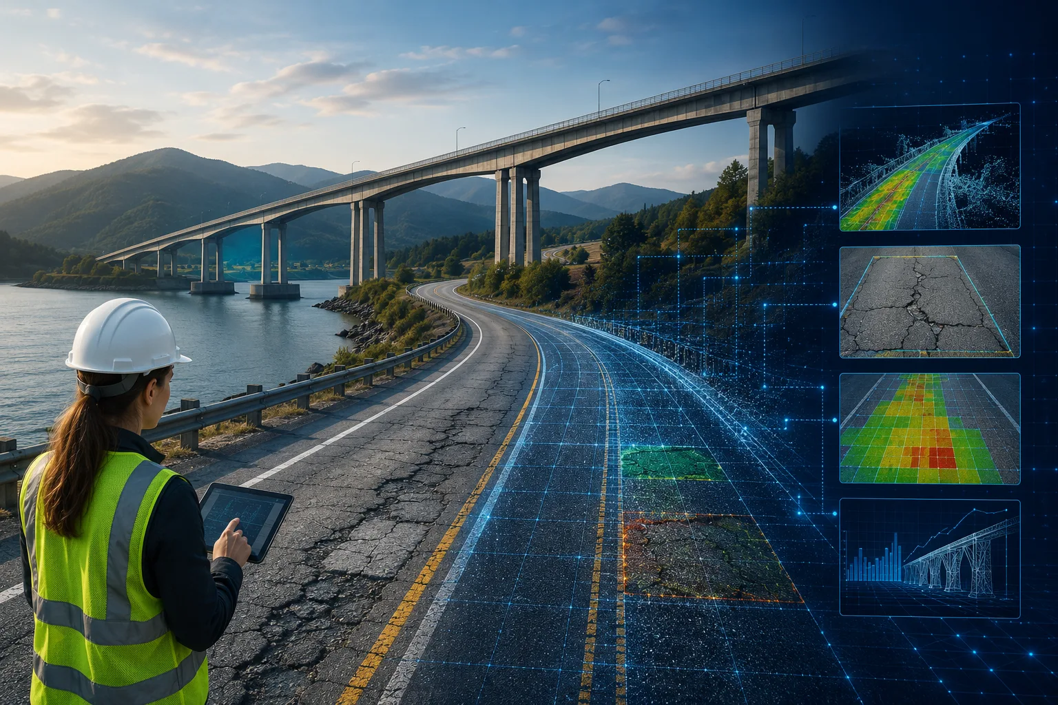
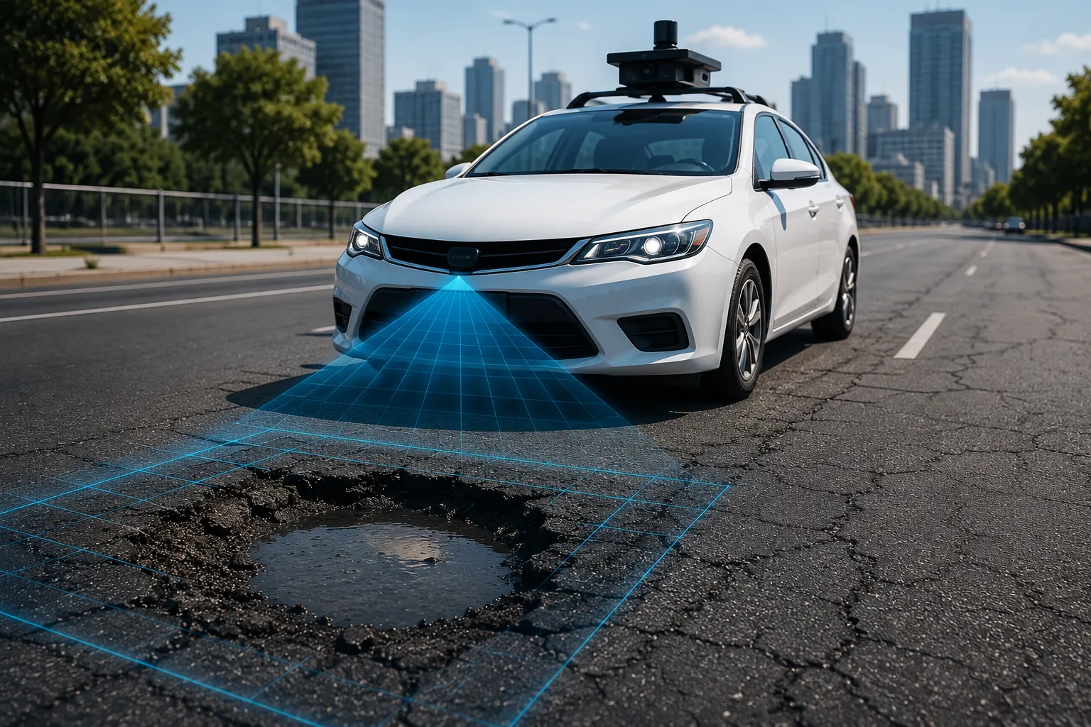
An AI-based road management system uses:
…to automatically assess and track road conditions in near real-time.
Core Capabilities Include:
Platforms like RoadVision AI are pioneering the deployment of such technology across emerging markets like South Africa.
RoadVision AI transforms routine road inspections by turning simple dashcam footage or mobile video into actionable maintenance intelligence. Here's how the Pavement Condition Intelligence Agent addresses South Africa's unique challenges:
4.1 Automated Pothole & Crack Detection
Using advanced computer vision models trained on South African road conditions, the system identifies:
Each defect is geo-tagged, severity-scored, and mapped according to TMH 9 classification standards.
4.2 Real-Time GIS Heatmaps
Engineers get a bird's-eye view of:
This supports prioritisation and planning aligned with SANRAL PMS strategies.
4.3 Predictive Maintenance for Budget Efficiency
RoadVision AI forecasts where failures are likely to appear next — helping agencies avoid runaway decay and "crisis maintenance" that drains resources. The system answers: "Which roads will fail in the next 6–12 months if left untreated?"
4.4 Scalable, Fleet-Based Data Collection
Municipal fleets, taxis, delivery vans, or refuse trucks can all be fitted with dashcams, creating a continuous road monitoring ecosystem that covers thousands of kilometres without dedicated survey vehicles.
4.5 Compliance with TMH 9 and SANRAL Guidelines
The platform produces structured, audit-ready outputs, ensuring alignment with national standards and enabling transparent reporting to stakeholders and funding bodies.
No solution is without hurdles. AI-driven systems must navigate:
5.1 Hardware & Camera Standardization
Different dashcams produce varying quality footage. Standard guidelines for camera positioning, resolution, and mounting help ensure consistent data quality.
5.2 Connectivity Gaps
Remote rural roads may have limited network coverage. RoadVision AI addresses this through offline-first AI processing and delayed cloud synchronization when connectivity returns.
5.3 Data Annotation & Model Updates
Road surfaces vary widely across provinces — from urban highways to gravel roads. Ongoing model refinement with local data ensures accuracy improves over time.
5.4 Limited Technical Capacity in Smaller Municipalities
Training and onboarding programs remain essential for long-term adoption, ensuring local teams can leverage AI insights effectively.
Despite these challenges, modern AI tools are rapidly overcoming barriers through edge processing, on-device computing, and lightweight deployment models that work within existing infrastructure.
South Africa stands at a turning point. With road conditions deteriorating and budgets tightening, relying purely on manual inspections is like "trying to mop the ocean with a bucket."
AI-based road management systems — especially platforms like RoadVision AI — offer a scalable, affordable, and highly accurate way to tackle potholes and broader pavement deterioration.
RoadVision AI enables:
With the right technology, South Africa can shift from reactive patchwork repairs to strategic, data-driven road asset management — building smarter, safer, and more sustainable roads for communities, commerce, and future generations.
Ready to transform how your municipality or agency tackles potholes? Book a demo with RoadVision AI today and discover how intelligent road management can fix South Africa's roads.
RoadVision AI uses advanced computer vision models to analyze road videos and identify potholes based on shape, size, and depth characteristics with high precision.
Yes, these systems reduce inspection costs, improve response times, and extend pavement life, making them highly cost-effective over time.
Yes, RoadVision AI provides dashboard that can be integrated with municipal asset and maintenance management systems seamlessly.

The Autonomous Road Engineer
AI that is transforming road infrastructure, from reactive to predictive.
.webp)