Africa's cities are growing at a pace the world can hardly ignore. Rapid urbanisation, rising motorisation, and expanding metropolitan boundaries have placed enormous pressure on already-strained transport systems. Congestion, unpredictable mobility patterns, and road safety challenges have now become everyday realities from Nairobi to Lagos, Johannesburg to Accra.
As governments aim to modernise mobility systems, the need for digital road asset management, real-time traffic intelligence, and data-driven planning has never been more urgent. Traditional methods—manual counts, ad-hoc surveys, periodic audits—can no longer keep up with the complexity of fast-expanding urban corridors.
This is where Artificial Intelligence (AI) steps in. AI-powered traffic analytics, road condition monitoring, and mobility optimisation tools are transforming how African cities plan, manage, and secure their transport networks. As the saying goes, "A stitch in time saves nine"—and AI helps cities take that stitch at precisely the right moment.
African cities face mobility challenges that are unique in scale and intensity:
Traditional traffic studies provide only a snapshot, but African cities need a continuous movie. AI through the Traffic Analysis Agent bridges this gap by offering:
2.1 Key Urban Challenges
2.2 Common Mobility Patterns
Across Africa, urban mobility development is guided by a combination of:
These frameworks emphasise three core principles:
AI through the Pavement Condition Intelligence Agent and Road Safety Audit Agent naturally aligns with all three. It enhances the quality, frequency, and precision of road and traffic data—helping road agencies meet regulatory expectations while delivering better public outcomes.
4.1 South Africa
4.2 Nigeria
4.3 Kenya
4.4 Rwanda
4.5 Ghana
RoadVision AI applies these principles by combining computer vision, machine learning, GIS mapping, and automated digital surveys through its integrated suite of AI agents to provide a full ecosystem of mobility intelligence.
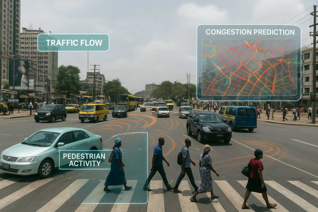
5.1 Real-Time Traffic Monitoring and Congestion Management
AI-enabled cameras and mobile survey units through the Traffic Analysis Agent capture real-time traffic flow, allowing authorities to:
This supports the design of adaptive signal control, intersection upgrades, and corridor optimisation, aligning cities with global ITS (Intelligent Transport Systems) best practices.
5.2 Predictive Congestion Analysis
AI models through the Traffic Analysis Agent analyse vehicle density, pedestrian volumes, and movement patterns to predict congestion before it materialises. This helps planners intervene early, demonstrating the proverb: "Forewarned is forearmed."
5.3 Enhanced Road Safety Intelligence
The Road Safety Audit Agent strengthens safety audits by detecting:
These insights enable governments to deploy targeted safety countermeasures and reduce crash risk.
5.4 AI-enabled Infrastructure Condition Monitoring
Through automated road condition surveys, the Pavement Condition Intelligence Agent identifies:
Cities gain a digital map of road conditions, enabling proactive maintenance, reduced lifecycle costs, and improved asset longevity.
5.5 Integrated Road Inventory and Asset Management
The Roadside Assets Inventory Agent supports digital road inventory creation by mapping:
This creates a unified asset database, essential for smart city governance.
5.6 Traffic Survey Automation at Scale
Instead of deploying manual counting teams for short durations, the Traffic Analysis Agent automates:
Cities receive richer datasets faster and at lower cost.
5.7 Informal Transport Integration
AI models capture:
While AI presents immense benefits, African cities must navigate challenges such as:
6.1 Limited Digital Infrastructure
Some regions lack reliable power, internet connectivity, and sensor networks for continuous monitoring.
AI Solution: Mobile surveys and offline-first data capture through RoadVision AI reduce infrastructure requirements.
6.2 Data Privacy and Governance Concerns
Video monitoring and traffic data collection require appropriate privacy protections.
AI Solution: Anonymized data processing and secure storage protocols maintain public trust.
6.3 Capacity-Building in Transport Agencies
Staff need training to interpret AI insights and integrate them into planning workflows.
AI Solution: Comprehensive training programs ensure successful adoption.
6.4 Inconsistent Availability of Historical Datasets
Limited historical data may affect predictive model accuracy initially.
AI Solution: AI builds datasets over time, improving predictions as data accumulates.
6.5 Budget Constraints for Initial Technology Deployment
Upfront investment in AI systems may be challenging for resource-constrained agencies.
AI Solution: Scalable, modular deployment allows starting with priority corridors and expanding based on demonstrated ROI.
6.6 Equipment Maintenance
Sensors and cameras require maintenance in challenging urban environments.
AI Solution: Remote monitoring and automated diagnostics reduce maintenance burden.
However, with scalable, modular solutions like RoadVision AI, governments can adopt AI gradually—starting with the highest-impact corridors and expanding as data maturity grows.
As the African proverb says, "The best time to plant a tree was 20 years ago. The second-best time is now." Investing in AI today ensures resilient, future-proof mobility for generations to come.
7.1 For City Authorities
7.2 For Road Users
7.3 For Economic Development
Africa is on the cusp of a mobility revolution. As urban populations grow and transport demands intensify, traditional tools can no longer sustain the pace. AI through the Traffic Analysis Agent, Pavement Condition Intelligence Agent, and Road Safety Audit Agent provides the clarity, continuity, and predictive intelligence needed to design congestion-free corridors, safer roads, and sustainable urban mobility systems.
The platform's ability to:
transforms how African cities approach urban mobility.
RoadVision AI is helping cities make this leap by delivering intelligent road condition monitoring, automated traffic survey analytics, comprehensive safety assessments, asset inventory digitisation through the Roadside Assets Inventory Agent, and predictive and data-driven planning support.
With AI-enabled infrastructure management, African cities can finally move from reacting to mobility problems to anticipating them—creating smarter cities that move "as smoothly as a well-oiled machine."
If your city or organisation is ready to transform its roads and mobility systems with AI, book a demo with RoadVision AI today to explore how our platform can support your journey to smarter, safer, and congestion-free urban mobility.
AI analyses real-time traffic conditions and predicts congestion patterns, enabling authorities to optimise signals, divert flow and prevent bottlenecks.
Yes. AI systems detect pedestrian activity, monitor vehicle conflicts and generate alerts for hazardous movements, supporting safer infrastructure design.
AI collects and analyses large-scale mobility, road condition and environmental data, providing insights that guide sustainable infrastructure investment.

The Autonomous Road Engineer
AI-powered road condition monitoring, asset management, & infrastructure intelligence helping agencies move from reactive maintenance to predictive road management.
.webp)
.webp)
.webp)