India's road network—one of the largest in the world—is the backbone of economic growth and rural–urban connectivity. As traffic volumes rise and climatic stresses intensify, ensuring pavement durability is no longer optional; it is essential. Highway agencies today must validate whether designed pavements are truly performing as intended on the ground.
This is where IRC SP 35, a key guideline published by the Indian Roads Congress, becomes indispensable. It prescribes a standardized framework for evaluating pavement conditions across national highways, state highways, MDRs, and urban roads.
With the emergence of AI-powered dashcam-based road surveys, agencies now have a faster, more objective, and more scientific way to validate pavement designs against IRC SP 35 criteria. As the old saying goes, "What gets measured gets managed." These new tools make measurement smarter, faster, and far more reliable.
A pavement may look fine today, but hidden failures can compromise safety and lead to costly future rehabilitation. Validating pavement design ensures:
Essentially, design validation prevents "penny-wise, pound-foolish" maintenance decisions by grounding them in field-proven evidence.
IRC SP 35 lays down a systematic methodology to evaluate the in-service performance of flexible pavements. Key principles include:
2.1 Identification and Measurement of Distresses
The guideline classifies and quantifies defects such as:
2.2 Serviceability Indicators
IRC SP 35 emphasizes:
2.3 Condition Rating System
Each distress type and severity level is assigned:
2.4 Standardized Data Collection Methods
The guideline permits:
Dashcam-based AI surveys align perfectly with these prescribed methods while dramatically improving coverage, consistency, and speed.
Modern dashcam-based automated pavement condition surveys have made IRC-compliant design validation significantly more scientific and scalable. RoadVision AI integrates best practices such as:
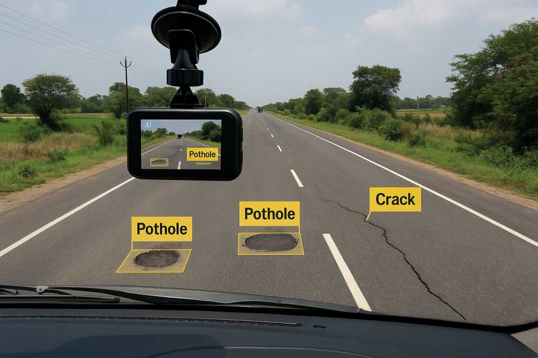
3.1 High-Speed Image-Based Distress Detection
The Pavement Condition Intelligence Agent uses dashcams mounted on regular inspection vehicles to capture HD imagery at traffic speeds. AI algorithms automatically identify:
This replaces slow, inconsistent manual inspections with objective, repeatable measurements.
3.2 Automated Rating as per IRC SP 35
The platform:
This ensures zero subjectivity and full IRC compliance across the entire network.
3.3 Roughness and Serviceability Measurement
Dashcam data integrated with accelerometer or smartphone sensor readings estimates roughness (in mm/km) consistent with IRC SP 35 requirements. When paired with skid resistance inputs from texture analysis, the system strengthens maintenance decision-making with multiple performance indicators.
3.4 GIS-Based Pavement Mapping
Every detected distress is geotagged with precise GPS coordinates and plotted on a GIS road network map. Engineers can overlay:
This helps validate whether the original pavement design assumptions hold true in the field and identify sections where designs need modification for future projects.
3.5 Integration with Road Asset Management Systems
RoadVision AI's platform integrates survey outputs into comprehensive Road Asset Management Systems for:
3.6 Temporal Change Detection
By comparing dashcam surveys over time, the Pavement Condition Intelligence Agent quantifies deterioration rates, validates design life assumptions, and measures the effectiveness of maintenance treatments.
As the proverb goes, "A stitch in time saves nine." Dashcam surveys ensure those stitches happen early, guided by data rather than guesswork.
Despite technological advancements, agencies still face practical challenges:
4.1 Limited Skilled Workforce
Engineers may need training to interpret automated survey outputs and understand AI-based analytics for design validation.
4.2 Integration with Legacy Databases
Older pavement records may be incomplete, paper-based, or stored in formats incompatible with modern systems.
4.3 Large-Scale Data Management
Dashcam-based surveys produce vast datasets requiring efficient cloud-based storage, processing, and retrieval capabilities.
4.4 Transition from Manual to Automated Surveys
Shifting from traditional methods requires confidence in automated outputs, calibration against manual benchmarks, and standardization across regions.
4.5 Correlation with Design Parameters
Linking observed distress patterns to specific design elements (layer thickness, material properties, drainage) requires integrated data systems.
4.6 Variability Across Contractors and Regions
Different construction quality and maintenance practices create variability that must be understood for accurate design validation.
RoadVision AI addresses these through:
Validating pavement design as per IRC SP 35 no longer needs to be slow, subjective, or limited in coverage. Dashcam-based AI surveys bring unprecedented precision, enabling agencies to assess road conditions at scale and with scientific consistency. By embracing these tools, India can ensure:
RoadVision AI is leading this revolution—leveraging advanced computer vision, digital twin modelling, and AI-driven analytics through the Pavement Condition Intelligence Agent, Road Safety Audit Agent, and Roadside Assets Inventory Agent to help authorities build smarter, safer, and longer-lasting roads that comply fully with IRC Codes.
The integration of dashcam surveys with IRC SP 35 evaluation creates a powerful feedback loop: designs inform monitoring, monitoring validates designs, and validated insights improve future designs. This continuous improvement cycle is essential for India's ambitious infrastructure programs, from Bharatmala to PMGSY.
If your organisation aims to modernise pavement condition evaluations and enhance design validation accuracy, book a demo with RoadVision AI today and experience how AI-powered road inspection can transform your pavement management strategy.
Q1: What is IRC SP 35 used for in pavement management?
It sets guidelines for condition surveys, distress measurements, and serviceability indicators to validate pavement design and plan maintenance activities.
Q2: How do dashcam-based surveys improve road condition assessment?
They automate distress detection, provide objective ratings, and comply with IRC SP 35 standards, reducing time and cost versus manual surveys.
Q3: Can AI road management help reduce road maintenance costs?
Yes. Predictive analysis from AI surveys enables preventive treatments, extending pavement life and avoiding expensive reconstructions.

The Autonomous Road Engineer
AI that is transforming road infrastructure, from reactive to predictive.

.webp)