Georgia's transportation network spans one of the most geographically diverse landscapes in the southeastern United States. From the steep Appalachian foothills in North Georgia to dense forest corridors and highly sensitive coastal highways, managing roadway assets across the state is a complex and continuous challenge.
For agencies responsible for road asset management in Georgia, maintaining an accurate and up-to-date road inventory is no longer a back-office task — it is essential for safety, resilience, and efficient investment.
Traditional inventory methods struggle to keep pace with Georgia's terrain, weather exposure, and expanding infrastructure demands. This is why AI-based road inventory management and automated road inventory survey systems are becoming critical tools for modern transportation planning.
By applying road asset management using AI through the Roadside Assets Inventory Agent, agencies can move beyond fragmented inspections toward a unified, continuously updated understanding of Georgia's road network.
Road inventory forms the foundation of infrastructure decision-making. It includes critical data on:
In Georgia, highways support freight logistics, tourism, evacuation routes, and daily commuter mobility. Even small gaps in asset data can translate into safety risks, delayed maintenance, and inefficient spending.
Accurate inventory enables agencies to:
Without reliable inventory information, maintenance becomes reactive rather than preventive — increasing long-term lifecycle costs.
2.1 Mountain Region (North Georgia)
2.2 Forest Corridors
2.3 Coastal Region (Southeast Georgia)
2.4 Urban and Suburban Areas (Metro Atlanta)
Conventional road inventory surveys typically rely on field crews conducting periodic inspections using handheld devices, spreadsheets, or paper-based systems. While widely used, this approach has structural limitations in a state like Georgia.
Most importantly, manual surveys cannot deliver the continuous visibility needed for modern asset lifecycle management.
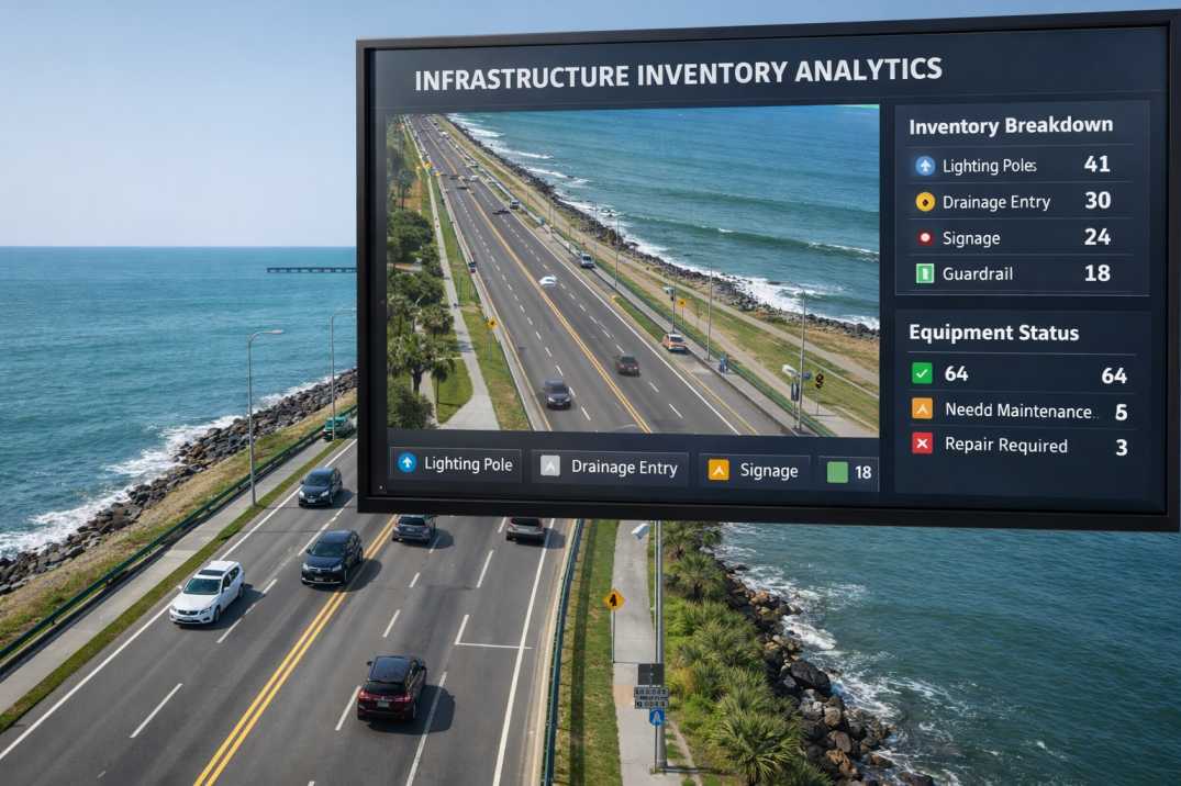
AI-based road inventory management through the Roadside Assets Inventory Agent introduces automation into asset detection, classification, and condition assessment.
Using computer vision algorithms, AI systems analyse video and image data collected from survey vehicles operating at normal traffic speeds. This enables agencies to identify roadside assets without disrupting traffic or placing inspectors at risk.
The key advantage is consistency. AI applies the same detection logic across:
Asset data is geo-referenced, digitally stored, and continuously updated, making statewide inventory far more reliable and usable.
An automated road inventory survey through the Roadside Assets Inventory Agent allows agencies to shift from periodic inspections to continuous monitoring.
Survey vehicles equipped with cameras collect data during routine operations, reducing the need for dedicated inspection runs.
This is especially valuable in Georgia where roadside conditions can change rapidly:
Instead of waiting months for the next inspection cycle, agencies can detect missing or damaged assets quickly.
6.1 Mountain Region Challenges
ChallengeImpactAI SolutionSteep gradesLimited access for manual inspectionVehicle-mounted surveys at traffic speedsSharp curvesDifficulty seeing around bends360-degree imaging and LiDARRockfall areasAssets damaged between cyclesContinuous monitoring detects changes
6.2 Forest Corridor Challenges
ChallengeImpactAI SolutionVegetation growthSigns and barriers obscuredVegetation detection and clearing alertsShaded areasMarking visibility reducedRetroreflectivity assessmentRemote locationsLong inspection cyclesMobile survey coverage without dedicated crews
6.3 Coastal Region Challenges
ChallengeImpactAI SolutionSalt corrosionRapid asset deteriorationFrequent condition updatesStorm damageAssets lost between inspectionsPost-event rapid assessmentHumidityMarking and sign degradationCondition trend monitoring
Modern automated road asset detection systems through the Roadside Assets Inventory Agent are trained to recognise infrastructure elements under varying lighting, weather, and terrain conditions.
This is essential in Georgia, where roads may transition within short distances from shaded forest tunnels to open rural highways to coastal urban zones.
Detected assets are automatically classified and logged into a digital inventory, forming a comprehensive AI-based infrastructure inventory.
Over time, this supports trend analysis — helping agencies identify locations with recurring failures or accelerated deterioration.
8.1 Traffic Control Assets
8.2 Safety Assets
8.3 Drainage Assets
8.4 Lighting Assets
8.5 Pavement Assets
Road inventory becomes significantly more valuable when linked with pavement condition and safety performance.
Asset visibility, pavement quality, and traffic exposure are interconnected factors influencing crash risk and maintenance priorities.
By integrating inventory outputs with:
Georgia agencies gain a clearer understanding of where missing or degraded assets contribute directly to operational risk.
This creates a unified, risk-based prioritisation framework rather than isolated asset tracking.
When inventory data is accurate, current, and comprehensive, agencies can move toward predictive and preventive strategies.
Road asset management using AI supports:
This is especially critical in Georgia's rural and environmentally sensitive regions, where delayed intervention leads to higher repair costs and greater safety exposure.
RoadVision AI provides a unified platform for AI-driven road inventory management through its integrated suite of AI agents designed to adapt to Georgia's geographic diversity.
Its solutions enable:
Georgia's mountain roads, forest corridors, and coastal highways each present unique challenges for road inventory management. Traditional inspection methods are no longer sufficient to maintain accurate, up-to-date asset data across such diverse environments.
AI-based road inventory management through the Roadside Assets Inventory Agent, enabled through automated road inventory surveys, provides a scalable, consistent, and safer alternative.
The platform's ability to:
transforms how road inventory is managed across Georgia's diverse regions.
RoadVision AI is transforming infrastructure development and maintenance through advanced AI-driven road technologies. The platform supports proactive asset monitoring, early pavement defect detection through the Pavement Condition Intelligence Agent, and smarter infrastructure decision-making — aligned with Georgia's transportation standards and broader regulatory requirements.
Book a demo with RoadVision AI today to modernise road inventory management across Georgia's diverse regions.
AI continuously captures and analyses road data, reducing human error and ensuring consistent asset detection across all terrains.
Yes AI systems are designed to detect assets even in low-visibility environments such as dense forests and shaded corridors.
Absolutely AI-generated inventories support predictive maintenance and lifecycle-based asset management.

The Autonomous Road Engineer
AI that is transforming road infrastructure, from reactive to predictive.
.webp)
.webp)
.png)