
India's National Highway network spans thousands of kilometres, connecting cities, industrial hubs, ports, and rural communities across the country. For drivers navigating these corridors, clear and consistent route guidance is essential. Long before GPS navigation became common, route marker signs played a critical role in helping motorists identify highway routes and maintain direction throughout their journeys.
To ensure uniformity across the national road network, the Indian Roads Congress introduced IRC:2-1968, which established standardized guidelines for route marker signs on National Highways in India. These standards continue to influence highway signage practices by promoting consistency, visibility, and safer navigation.
Today, modern technologies such as AI highway sign detection and computer vision route sign detection in India are helping road authorities digitize and monitor signage assets more efficiently than ever before.
Road signs are far more than informational tools. They are critical safety assets that help drivers:
Without standardized route markers, drivers can experience uncertainty, sudden lane changes, missed turns, and increased accident risks.
The introduction of IRC:2-1968 route marker signs for National Highways in India helped establish a consistent visual language across the country's expanding road infrastructure.
The concept of route marker signs was initially introduced by the Ministry of Transport in 1952. Following consultations with Chief Engineers from various states, a standardized design was adopted in 1953.
With India's transition to the metric system, the Indian Roads Congress revised the standards in 1968, resulting in IRC:2-1968, which introduced updated dimensions, improved readability, and greater consistency for highway users.
These guidelines became the foundation for route identification across India's National Highway system.
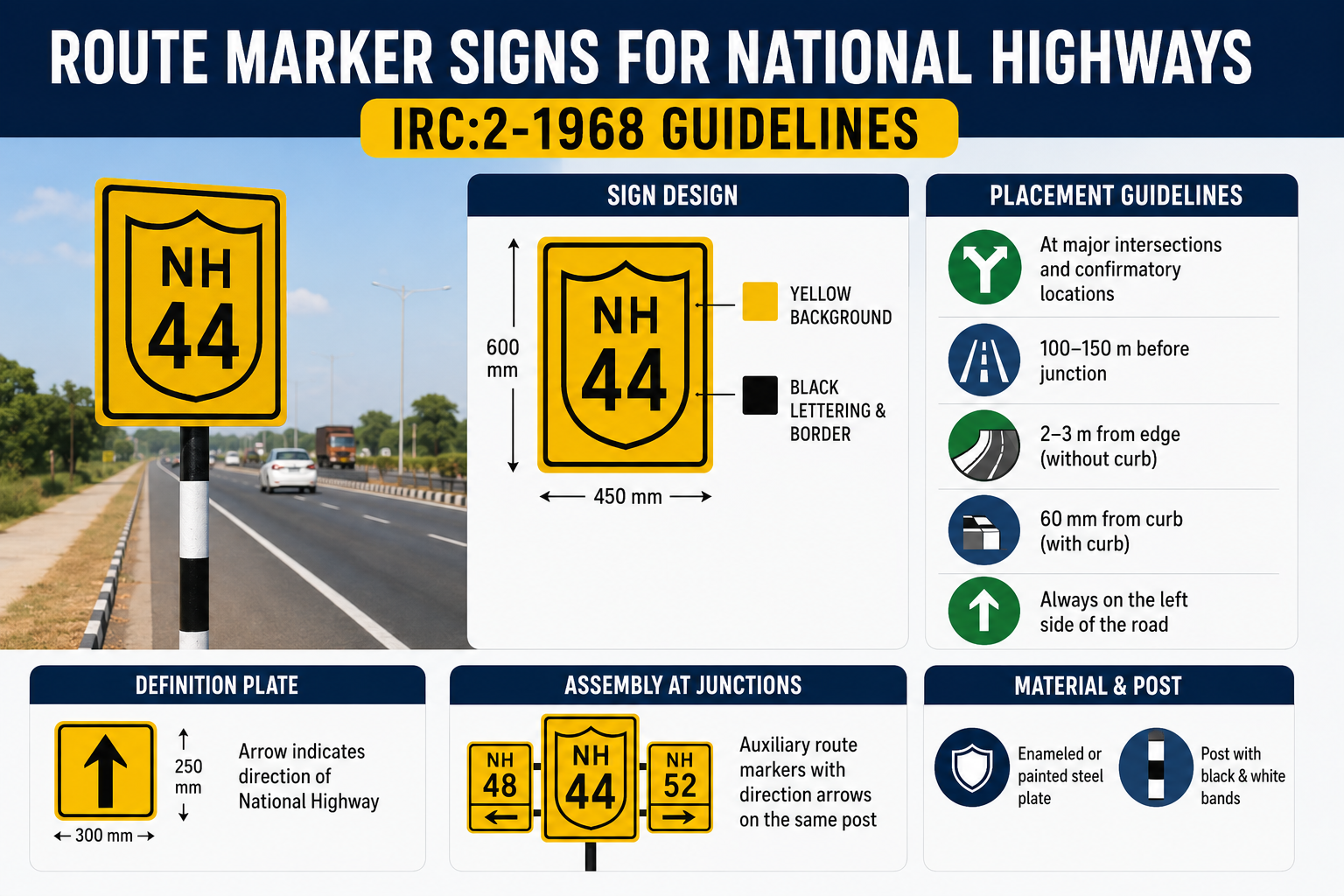
According to IRC:2-1968, the route marker consists of a shield-shaped symbol displayed on a rectangular plate.
The standard sign dimensions are:
This design ensures sufficient visibility for drivers travelling at highway speeds.
The code specifies a highly visible colour combination designed to maximize readability under various lighting conditions.
Key features include:
These standards remain relevant for modern national highway sign compliance AI monitoring systems that assess signage quality and visibility.
To maintain consistency throughout the highway network, IRC:2-1968 provides detailed specifications for:
Standardized typography improves sign recognition and minimizes driver confusion.
Today, AI road sign condition assessment using dashcam data can automatically evaluate whether signage remains compliant with visibility and readability requirements.
Correct placement is as important as proper design.
Route markers should be installed:
These placement strategies help maintain continuity for drivers throughout their journey.
IRC:2-1968 recommends specific offsets depending on roadside conditions.
For roads without curbs:
For roads with curbs:
Additionally, signs should be slightly angled away from approaching traffic to reduce glare and improve visibility.
Route marker signs should generally be installed:
This provides drivers with sufficient reaction time to make navigation decisions safely.
Modern AI road asset inventory route markers in India can automatically verify sign placement and identify missing or damaged markers across extensive highway networks.
At junctions, route markers are often accompanied by definition plates.
These plates:
Definition plates clarify the direction of the National Highway and help drivers understand whether the route continues straight ahead, turns, or intersects with another highway.
Where two numbered highways intersect, IRC:2-1968 recommends route marker assemblies.
These assemblies include:
This arrangement improves route continuity and reduces navigation errors at complex junctions.
Today, NHAI route marker sign compliance AI systems can automatically assess intersection signage and ensure correct route marker assemblies are in place.
Durability is essential for roadside infrastructure.
IRC:2-1968 recommends manufacturing route markers using:
To reduce visual distraction:
These standards help maintain visibility while ensuring long service life.
Managing thousands of signs manually is both time-consuming and expensive.
Today, transportation agencies are increasingly using AI highway route sign inventory systems in India to automate inspections and asset management.
Advanced platforms such as RoadVision AI enable agencies to:
Using computer vision route sign detection in India, authorities can identify route markers from vehicle-mounted cameras and survey footage.
AI algorithms can evaluate:
Modern AI road inventory management platforms create continuously updated inventories of route markers and other roadway assets.
Road authorities can compare field conditions against IRC national highway sign design standards to identify missing, damaged, or non-compliant signage.
This significantly improves inspection efficiency while reducing maintenance costs.
The principles established by IRC:2-1968 continue to provide important benefits:
When combined with modern AI-powered inspection technologies, these benefits become even more powerful.
The IRC:2-1968 Route Marker Sign standards for National Highways remain an important milestone in India's road infrastructure development. By standardizing sign design, placement, and visibility requirements, the code created a unified navigation system that supports safer and more efficient travel across the country.
As India's highway network continues to expand, modern technologies such as AI highway sign detection, road signage audit AI tools and AI road asset inventory systems are helping authorities maintain these standards more effectively than ever before.
By combining proven IRC guidelines with intelligent digital monitoring, road agencies can improve asset management, strengthen compliance, and deliver a safer driving experience for millions of road users.
See how RoadVision AI helps agencies detect, map, inspect, and manage highway route markers using AI-powered road asset inventory and compliance monitoring.
IRC:2-1968 is the Indian Roads Congress standard that defines the design, dimensions, placement, and usage of route marker signs on National Highways in India.
Route marker signs help drivers identify highway numbers, navigate junctions, confirm routes, and improve overall road safety and traffic efficiency.
AI-powered road asset management systems can automatically detect route markers, assess sign condition, maintain digital asset inventories, and monitor compliance with IRC highway signage standards.

The Autonomous Road Engineer
AI-powered road condition monitoring, asset management, & infrastructure intelligence helping agencies move from reactive maintenance to predictive road management.


.webp)
.webp)
.webp)