Road markings are among the most visible yet often overlooked components of road infrastructure. Every day, millions of drivers rely on pavement markings to stay within lanes, make safe overtaking decisions, and navigate complex road environments. Among these markings, longitudinal road markings play a particularly important role because they continuously guide traffic movement along the roadway.
To ensure consistency across India's road network, the Indian Roads Congress established clear guidelines through IRC:35-2015 – Code of Practice for Road Markings. These standards define how markings should be designed, installed, maintained, and monitored to support safer roads and more efficient traffic flow.
Today, modern technologies such as AI longitudinal road marking inspection, computer vision-based compliance monitoring, and automated pavement audits are helping authorities maintain road marking quality at scale.
As the saying goes, "Roads speak through their markings." The clearer the message, the safer the journey.
IRC:35-2015, the Code of Practice for Road Markings, establishes national standards for pavement marking design, installation, materials, visibility requirements, and maintenance procedures.
The code provides guidance on:
Its objective is to ensure uniform road user understanding across highways, expressways, urban roads, and rural corridors.
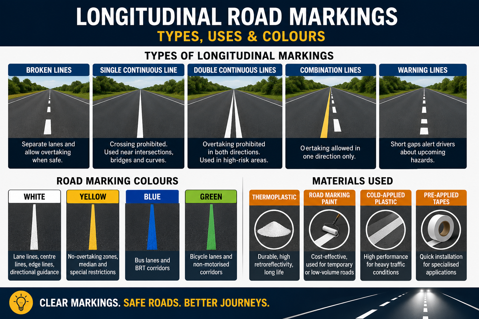
Longitudinal road markings are pavement lines placed parallel to the direction of traffic movement.
Their primary functions include:
These markings are among the most important visual traffic control devices used in modern road safety engineering.
Broken lines are used where lane changes and overtaking are permitted under safe conditions.
Common applications include:
These markings provide guidance while allowing operational flexibility.
Single continuous lines indicate that crossing the line is prohibited.
They are commonly installed near:
These markings help reduce unsafe overtaking manoeuvres.
Double continuous lines provide stronger overtaking restrictions in high-risk locations.
Typical applications include:
They improve safety by clearly separating opposing traffic streams.
Combination lines consist of one broken line and one continuous line.
They permit overtaking for traffic travelling in one direction while restricting overtaking in the opposite direction.
This arrangement improves traffic efficiency without compromising safety.
Warning lines use shorter gaps between line segments to alert drivers about upcoming hazards.
They are commonly used before:
These markings give drivers additional reaction time before entering restricted sections.
The road marking colour code India IRC system ensures consistent interpretation of road markings nationwide.
Used for:
Used for:
Reserved for dedicated transit lanes such as Bus Rapid Transit corridors.
Typically used for cycle tracks and non-motorized transport facilities.
Standardized colour coding improves driver recognition and reduces confusion across different states.
The durability and visibility of road markings depend heavily on material selection.
Thermoplastic materials are widely used on highways because they offer:
Paint-based markings are cost-effective and commonly used for:
Suitable for high-traffic corridors where longer service life is required.
Often used in specialised locations requiring rapid installation and high visibility.
Compliance with road marking material specifications IRC 35 helps ensure long-term performance and reduced maintenance costs.
Road markings must remain visible during night-time and poor weather conditions.
IRC:35 requires:
Poor retroreflectivity significantly reduces driver reaction time and increases crash risk.
Modern AI road marking retroreflectivity monitoring solutions are helping authorities assess visibility performance more efficiently across large networks.
Maintaining road markings manually across thousands of kilometres can be challenging.
Today, agencies are increasingly using:
These technologies can automatically identify:
As a result, authorities can improve maintenance planning while reducing inspection costs.
RoadVision AI helps road authorities maintain compliance with IRC 35 longitudinal road markings through advanced AI-powered infrastructure monitoring.
The platform supports:
Computer vision algorithms automatically identify deteriorated markings before they become safety hazards.
Large road networks can be assessed quickly using vehicle-mounted cameras and AI analytics.
The platform tracks marking deterioration over time, enabling proactive maintenance decisions.
RoadVision AI combines pavement condition monitoring with marking assessments to provide a comprehensive view of roadway performance.
By digitising inspections and improving data accuracy, RoadVision AI enables safer, more efficient, and more compliant road networks.
Although often overlooked, longitudinal road markings are among the most critical components of road safety infrastructure. When designed and maintained according to IRC:35-2015, they improve lane discipline, regulate overtaking, enhance visibility, and reduce crash risks across India's road network.
As infrastructure agencies move toward data-driven asset management, technologies such as AI longitudinal road marking inspection, automated lane marking detection India, and computer vision road marking compliance systems are becoming essential tools for maintaining road marking quality at scale.
See how RoadVision AI helps agencies automate pavement marking audits, detect faded lane markings, and maintain IRC-compliant road safety infrastructure. Book a demo today.
Longitudinal road markings are pavement markings placed parallel to traffic flow. They include lane lines, centre lines, edge lines, and no-overtaking markings used to guide vehicles and improve road safety.
AI-powered inspection systems use computer vision and machine learning to detect faded markings, retroreflectivity loss, wear patterns, and compliance issues, enabling faster and more accurate maintenance planning.
IRC 35 recommends thermoplastic markings, road marking paint, cold-applied plastics, and preformed adhesive tapes depending on traffic volume, durability requirements, and roadway conditions.

The Autonomous Road Engineer
AI that is transforming road infrastructure, from reactive to predictive.
.webp)
.webp)
.png)