As Indian cities expand at an unprecedented pace, urban roads are under immense pressure—from rising traffic volumes to increasing utility demands. In this environment, poorly planned roads become bottlenecks, slowing mobility, increasing accidents, and escalating maintenance costs. To avoid the classic trap of "digging a well when the house is already on fire," engineers must rely on standardised and forward-looking design practices.
This is where IRC SP:50, issued by the Indian Roads Congress, becomes indispensable. It serves as a comprehensive national manual for urban road design, covering geometric standards, cross-sections, intersection planning, pavement considerations, and more. With the growing adoption of AI-driven road inspection and predictive analytics, aligning design parameters with IRC SP:50 is no longer optional—it's pivotal for building safe, durable, and "future-ready" urban mobility networks.
Urban roads today need to do much more than carry vehicles—they must facilitate pedestrians, cyclists, utilities, parking, drainage, and smart-city systems. IRC SP:50 ensures uniformity, safety, and functionality across all these components.
Its design parameters help engineers:
In short, IRC SP:50 ensures we "build right the first time," reducing costly rework and enabling efficient urban development.
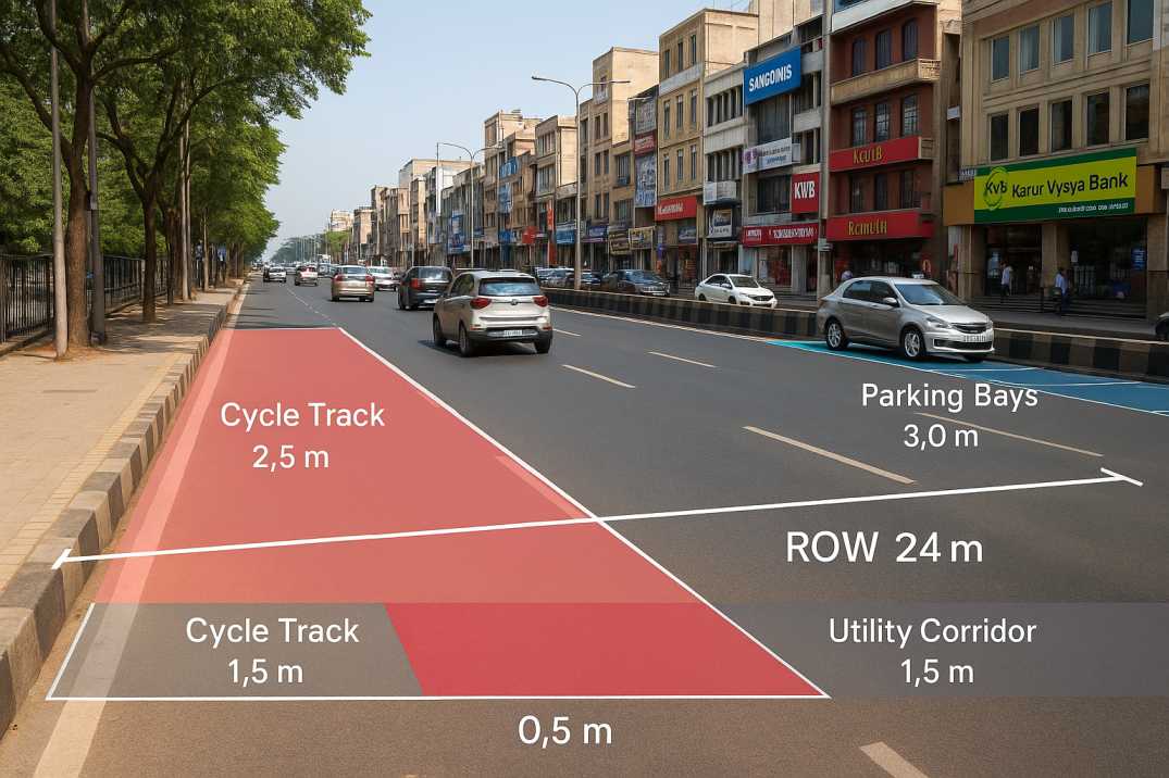
2.1 Right of Way (ROW)
The ROW defines the total land width reserved for a road—including carriageway, footpaths, utilities, and medians. IRC SP:50 recommends ROW between 12 m and 60 m depending on whether the road is residential, sub-arterial, or arterial.
Why it matters: ROW dictates the scope of infrastructure and pedestrian movement possible within the corridor. The Roadside Assets Inventory Agent can verify actual ROW compliance against design specifications.
2.2 Carriageway Width
Standard lane width under IRC SP:50 is 3.5 metres per lane, with flexibility based on road category and traffic volume. Multi-lane urban roads must maintain consistent lane widths throughout.
Why it matters: Proper lane width ensures safe vehicle operation and accommodates different vehicle classes sharing the road.
2.3 Cross-Section Elements
Urban road sections typically include footpaths, cycle tracks, parking bays, medians, and drainage channels. IRC SP:50 mandates footpaths of 1.5–2.0 metres in residential areas and wider in commercial zones.
Why it matters: Complete cross-sections support all road users, not just motorised vehicles.
2.4 Horizontal Alignment
Horizontal curves must be gentle, safe, and accompanied by appropriate transition curves. This ensures better visibility and fewer crash risks at curved sections.
Why it matters: Poor horizontal alignment is a leading cause of run-off-road crashes. The Road Safety Audit Agent can verify alignment compliance.
2.5 Vertical Alignment and Gradient
IRC SP:50 prescribes maximum gradients of:
Why it matters: Proper gradients ensure drainage, vehicle performance, and safety for all users, including cyclists and pedestrians.
2.6 Intersection Design
Proper design—whether roundabouts, channelised intersections, or signalised junctions—is essential to prevent congestion and enhance pedestrian safety at conflict points.
Why it matters: Intersections account for a disproportionate share of urban crashes and delays.
2.7 Sight Distance
Both SSD (Stopping Sight Distance) and OSD (Overtaking Sight Distance) are defined based on design speed and gradients. Adequate visibility saves lives at curves, intersections, and pedestrian crossings.
Why it matters: The Road Safety Audit Agent can automatically verify sight distance compliance from video surveys.
2.8 Pavement Design Considerations
Although IRC SP:50 references IRC:37 for detailed pavement design, it outlines basic layer thickness requirements and material properties based on traffic load classification.
Why it matters: Proper pavement design prevents premature failure. The Pavement Condition Intelligence Agent monitors condition to validate design assumptions.
2.9 Pedestrian Facilities
Footpaths, zebra crossings, pedestrian signals, kerb ramps, and guardrails are mandated in high-movement urban areas to protect vulnerable road users.
Why it matters: Over 40% of urban crash fatalities involve pedestrians—adequate facilities save lives.
2.10 Parking and Utility Management
IRC SP:50 includes recommendations for on-street and off-street parking, as well as dedicated corridors for underground utilities to avoid repeat digging that damages road structure.
Why it matters: Poor utility coordination leads to frequent trenching and premature pavement failure.
Modern road agencies increasingly rely on AI-driven tools to ensure compliance with IRC SP:50. RoadVision AI uses computer vision, geospatial analytics, and predictive modelling to:
3.1 Validate Carriageway and ROW Dimensions
Automated cross-section extraction from video surveys ensures accurate lane, footpath, and median measurements against IRC SP:50 specifications.
3.2 Detect Geometric Deviations
RoadVision flags non-standard curves, improper gradients, and sight distance obstructions automatically through the Road Safety Audit Agent.
3.3 Automate Pavement Distress Identification
Cracks, potholes, rutting, and surface failures are detected using deep-learning algorithms through the Pavement Condition Intelligence Agent.
3.4 Perform Real-Time Traffic Behaviour Studies
RoadVision's Traffic Analysis Agent provides insights into queue lengths, turning movements, and peak-hour flow to validate intersection design assumptions.
3.5 Build Digital Twins for Urban Roads
These help authorities visualise existing conditions and plan upgrades while staying compliant with IRC SP:50 norms, using the Roadside Assets Inventory Agent for complete asset mapping.
In short, RoadVision AI helps engineers "measure twice and cut once," ensuring precision, efficiency, and robust planning.
Despite its clarity, several practical hurdles exist:
4.1 Legacy Road Networks
Many older urban roads lack sufficient ROW, requiring redesigns or compromises that challenge full compliance.
4.2 Incomplete or Inaccurate Data
Traditional surveys are labour-intensive, error-prone, and expensive, leading to design decisions based on incomplete information.
4.3 Utility Congestion Beneath Roads
Frequent digging by multiple agencies disrupts the integrity of road assets and undermines design assumptions.
4.4 Rapid Urbanisation
Demand for new roads often outpaces the capacity to plan them optimally, leading to compromised designs.
4.5 Limited Adoption of Technology
Many authorities still rely on manual assessments instead of automated AI systems that could verify compliance continuously.
This is where AI-enabled tools like RoadVision AI create a significant advantage.
Urban roads are the lifelines of India's cities, and designing them well is both an engineering responsibility and a civic necessity. IRC SP:50 provides a solid foundation—but the true transformation happens when standards meet technology.
RoadVision AI is redefining this landscape by combining AI, digital twin modelling, computer vision, and predictive analytics to ensure that Indian roads don't just meet IRC SP:50 standards—they exceed them. As the saying goes, "A stitch in time saves nine," and early detection of road issues through AI can save crores of rupees while making roads safer for millions.
If your organisation is aiming for complete IRC SP:50 compliance while embracing modern, AI-driven road asset management, book a demo with RoadVision AI today and experience how intelligent infrastructure planning can revolutionise your city's mobility future.
Q1. What is the minimum lane width in urban areas as per IRC SP:50?
According to IRC SP:50, the standard lane width in urban areas is 3.5 meters.
Q2. How does AI help in IRC SP:50 compliance?
AI tools enable automatic inspection, defect detection, and compliance validation for road elements like width, curves, and intersections.
Q3. What is the ideal ROW for arterial urban roads?
As per IRC SP:50, the ideal Right of Way (ROW) for arterial roads in urban areas is typically between 30 to 60 meters.

The Autonomous Road Engineer
AI that is transforming road infrastructure, from reactive to predictive.
.webp)
.webp)
.png)