India's road infrastructure ecosystem is evolving at lightning speed. Yet, traditional methods of tracking construction progress—manual inspections, scattered site photographs, and periodic site visits—struggle to keep pace with modern project demands. As AI road asset management becomes mainstream, drone-based monitoring is emerging as one of the most transformative tools in the sector.
By combining drones with AI platforms like RoadVision AI, agencies now have access to faster, safer, and more accurate progress monitoring across national highways, rural roads, urban corridors, and PPP projects. In a sector where delays and cost overruns can derail entire timelines, drones offer the clarity and control that traditional systems simply cannot match.
As the saying goes, "A bird's-eye view sees what the ground cannot." Drones make that bird's-eye view a daily reality.
.jpg)
The reason is simple: traditional monitoring is slow, fragmented, and human-dependent, whereas drones provide real-time, comprehensive, and verifiable data.
Key pain points with old methods include:
In contrast, drone-based monitoring supports rapid visualisation, milestone verification, and automated reporting—core requirements for today's AI-driven road infrastructure programmes.
The Indian Roads Congress provides a structured framework for quality, safety, and lifecycle management across road projects through guidelines such as:
Drone integration strengthens these principles by enabling:
In effect, drones don't replace IRC standards—they amplify them.
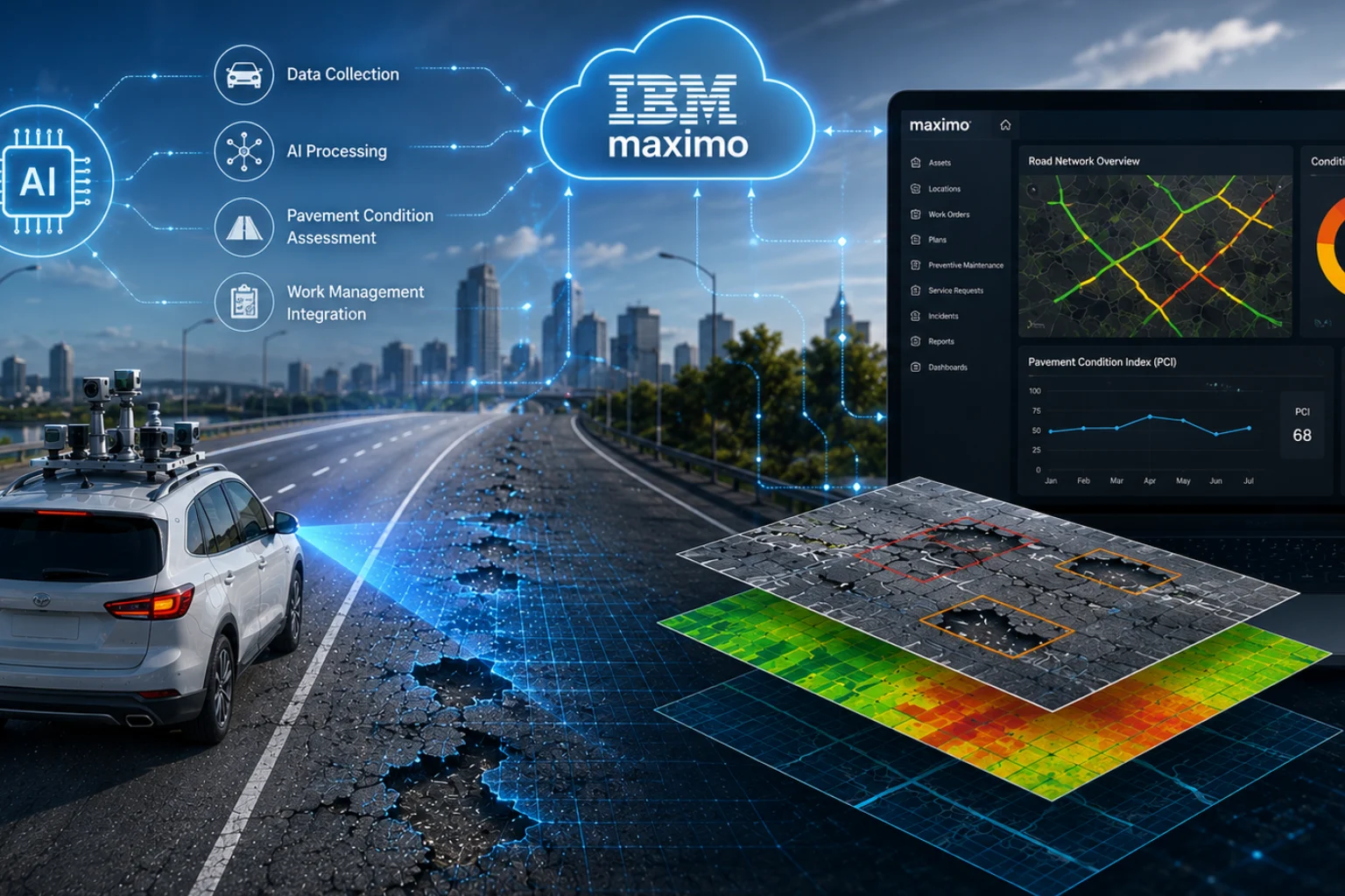
The real value of drones is unlocked when they are integrated with AI-driven road asset systems. Here's how RoadVision AI transforms drone data into actionable intelligence through its integrated suite of AI agents:
3.1 Real-Time Progress Tracking Through High-Resolution Visual Data
Drone flights capture:
RoadVision AI automatically processes this data to:
This ensures that decision-makers get the whole picture, not just snapshots from occasional site visits.
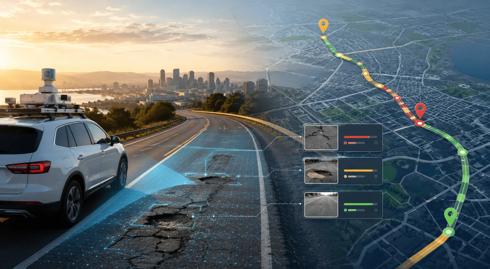
3.2 Enhanced Accuracy in Pavement and Asset Inspection
Drones sharply capture defects and anomalies that are often invisible from ground level, including:
When fed into AI modules like the Pavement Condition Intelligence Agent, these insights help engineers intervene early—because "a stitch in time saves nine."
3.3 Improved Safety for Engineers and Road Users
Survey teams no longer need to stand on active carriageways or unstable subgrades. Drone-based monitoring helps:
These inputs support safety audits performed through the Road Safety Audit Agent, reducing risks for both project teams and road users.
3.4 Cost Efficiency and Faster Reporting Cycles
Drone-based monitoring significantly cuts down:
Complete stretches can be mapped in hours instead of days, enabling faster detection of bottlenecks, material shortages, or quality lapses. For PPP and EPC projects, this improves billing accuracy, milestone verification, and contractual transparency.
3.5 Seamless Integration with AI Road Asset Management Platforms
Drone data is:
RoadVision AI integrates drone inputs with modules such as:
This creates a unified ecosystem where data is not just collected—it is interpreted, analysed, and transformed into actionable intelligence.
Despite the advantages, certain barriers remain:
However, as the proverb suggests, "Where there's a will, there's a way." India's push for digital infrastructure under programmes like PM Gati Shakti and the National Infrastructure Pipeline is steadily removing these hurdles through streamlined approvals, capacity building, and technology adoption incentives.
Drones combined with AI are redefining how India builds, monitors, and maintains roads. They offer unmatched precision, enhanced safety, rapid reporting, and real-time compliance monitoring—all essential for modern infrastructure governance.
RoadVision AI is leading this transformation by integrating drone intelligence with computer vision, digital twins, and automated analytics. The result is an ecosystem where engineers can:
Through the integrated capabilities of the Pavement Condition Intelligence Agent, Road Safety Audit Agent, Roadside Assets Inventory Agent, and Traffic Analysis Agent, RoadVision AI delivers comprehensive construction monitoring that goes beyond traditional methods.
As India accelerates toward smarter and more sustainable infrastructure, drone and AI synergy will become the norm—not the exception. The agencies that embrace this technology today will be the ones delivering projects faster, with higher quality, and at lower cost tomorrow.
If you're ready to see your projects from a smarter, higher, and more accurate perspective, book a demo with RoadVision AI today and discover how drone-powered monitoring can transform your construction oversight.
Q1. How accurate are drones in construction progress monitoring?
Drones can achieve centimeter-level accuracy when integrated with GPS and AI systems, making them highly reliable for construction tracking.
Q2. Can drone data be integrated with AI-based platforms?
Yes, drones are designed to work seamlessly with AI systems for real-time data analysis, mapping, and visual reporting.
Q3. Are drones useful in rural and remote road projects?
Absolutely. Drones are especially useful in inaccessible, rural, or hilly terrains where manual surveys are difficult or time-consuming.

The Autonomous Road Engineer
AI that is transforming road infrastructure, from reactive to predictive.
.webp)