In an era where AI-powered road inspections and automated roadway element detection are becoming the new norm rather than the exception, the quality of roadway data is no longer a "nice-to-have"—it's the beating heart of modern transportation management. To support this shift, the Federal Highway Administration developed MIRE 2.1, a standardized blueprint that helps agencies across the United States collect high-quality, uniform roadway and traffic data.
With growing adoption of AI-driven tools like RoadVision AI, understanding MIRE 2.1 is essential for building safer, smarter, and more sustainable road networks.
The United States has thousands of miles of public roads—urban, rural, paved, unpaved, major corridors, and local streets—each requiring reliable, consistent data for safety and planning. Under federal regulations, states must collect 37 Fundamental Data Elements (FDEs) by September 30, 2026, including:
This mandate supports safety analysis, funding allocation, and federal compliance, particularly with programs like the Highway Safety Improvement Program (HSIP).
As the saying goes, "You can't fix what you can't measure." MIRE 2.1 ensures every agency measures roadway conditions the same way—accurately, consistently, and across the entire nation.
MIRE 2.1 is much more than a list of roadway attributes. Its structure is deeply aligned with:
Because MIRE 2.1 aligns with the Highway Safety Manual, the data States collect directly supports engineering decisions, risk assessments, and safety investments at the project and network levels.
In other words, MIRE 2.1 turns raw roadway details into actionable intelligence—enabling agencies to "see the storm before it hits" by predicting hazards before they become crashes.
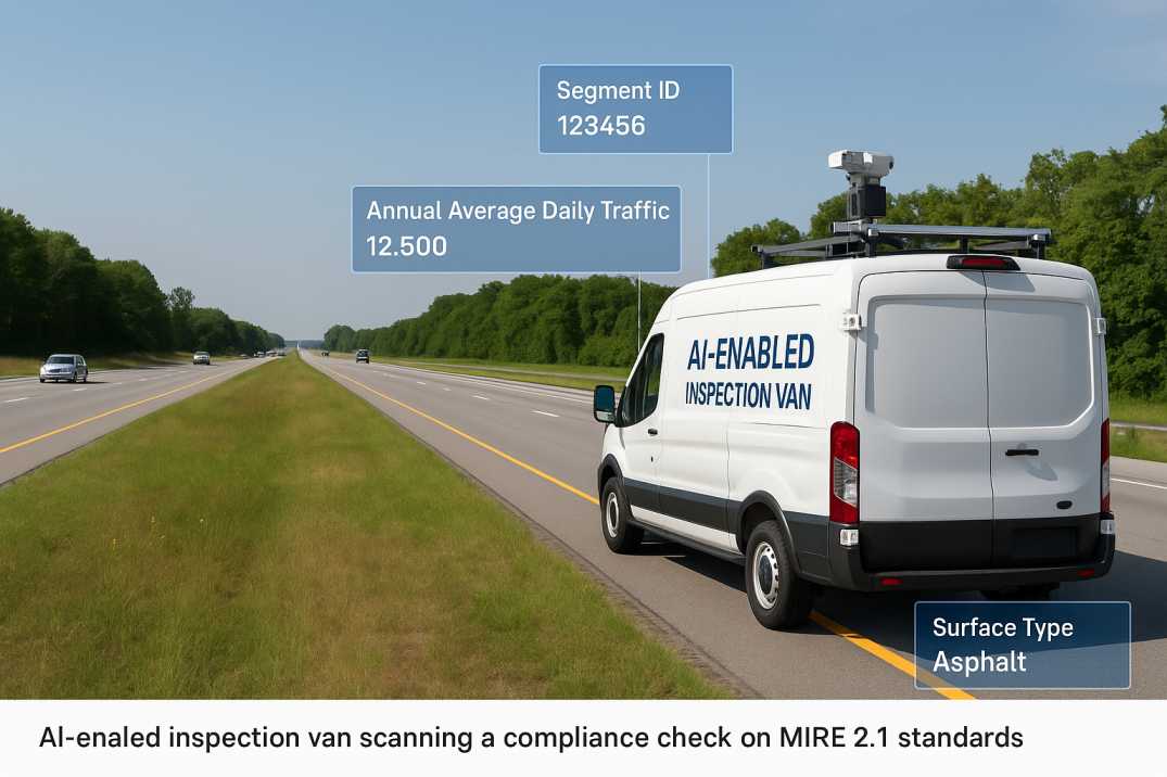
AI-powered roadway inspection tools like RoadVision AI are transforming how agencies achieve MIRE 2.1 compliance. Instead of sending teams into the field for slow, manual surveys, RoadVision AI automates the detection and extraction of MIRE 2.1 elements using:
RoadVision AI enables agencies to:
3.1 Automate MIRE-Compliant Data Collection
Video feeds from routine fleet operations are converted into detailed MIRE 2.1 roadway attributes—lane count, signage inventory, surface condition, shoulder type, median presence, and more—without manual data entry.
3.2 Reduce Costs and Downtime
Field work that once took weeks or months can now be completed in hours using existing vehicles during normal operations, eliminating dedicated survey missions.
3.3 Improve Consistency Across Networks
The Roadside Assets Inventory Agent removes human bias and provides uniform outputs across all roadway classes, ensuring data quality meets federal standards regardless of which inspector covers which segment.
3.4 Enable Predictive Safety Planning
Insights from pavement quality, intersection geometry, crash patterns, and roadside features support early intervention strategies aligned with the Highway Safety Improvement Program.
3.5 Deliver Analytics Aligned with Federal Standards
Interactive dashboards mirror MIRE categories, simplifying reporting and compliance checks for FHWA submissions and HSIP grant applications.
In short, RoadVision AI helps agencies "work smarter, not harder" while meeting federal mandates.
Despite its value, MIRE 2.1 presents several hurdles:
4.1 Legacy Systems and Poor Data Integration
Older Linear Referencing Systems (LRS) and fragmented GIS platforms often struggle to align with the detailed MIRE schema, creating data silos and inconsistency.
4.2 Limited Resources
Many municipalities and even state DOTs lack the staff or budget for large-scale manual surveys covering thousands of miles annually.
4.3 Geospatial Accuracy Requirements
MIRE demands highly accurate location data for roadway elements, which traditional GPS-based methods often fail to deliver at the required precision.
4.4 Rising Expectations from Federal Oversight
With federal funding tied to compliance, agencies must ensure consistent quality across all public roads—not just the National Highway System.
4.5 Maintaining Currency
Roadway conditions change due to construction, maintenance, and deterioration. Static datasets become obsolete quickly without continuous updates.
AI-powered systems like RoadVision AI bridge these gaps, offering automation, precision, and real-time validation that manual methods cannot match.
MIRE 2.1 is far more than a federal requirement—it's a roadmap for the future of roadway data management in the United States. As transportation agencies shift toward digital workflows, predictive safety analysis, and proactive infrastructure planning, standardized data becomes the cornerstone of progress.
RoadVision AI is leading this transformation by enabling:
In the words of a timeless proverb, "The best time to plant a tree was 20 years ago. The second-best time is now." The same applies to building high-quality roadway datasets that meet MIRE 2.1 requirements.
If your agency is ready to modernize road asset management, improve safety, and stay ahead of federal requirements, book a demo with RoadVision AI today and discover how we can partner in your journey toward smarter, safer infrastructure.
Q1. What is the deadline for MIRE 2.1 compliance?
All U.S. States must have access to MIRE Fundamental Data Elements on public roads by September 30, 2026, per FHWA regulations.
Q2. How can AI help with MIRE 2.1 compliance?
AI enables automated data collection, reduces errors, enhances coverage, and aligns collected data directly with MIRE specifications.
Q3. What data is included in MIRE FDEs?
MIRE FDEs include 37 essential elements such as road type, traffic volume, intersections, surface type, and ramp features.

The Autonomous Road Engineer
AI-powered road condition monitoring, asset management, & infrastructure intelligence helping agencies move from reactive maintenance to predictive road management.

.webp)
.webp)