In road engineering, few parameters are as fundamental—and as unforgiving—as sight distance. It directly governs driver safety, dictates speed environment, influences crash risk, and determines whether a highway or rural road meets national design standards. As the saying goes, "What you can't see can hurt you," and nowhere is this truer than on roads where inadequate visibility can turn an otherwise acceptable alignment into a hazardous one.
Under the standards developed by Austroads, minimum sight distance must be satisfied across curves, crests, intersections, and overtaking zones. Falling short often results in substandard design, flagged repeatedly during audits and safety inspections.
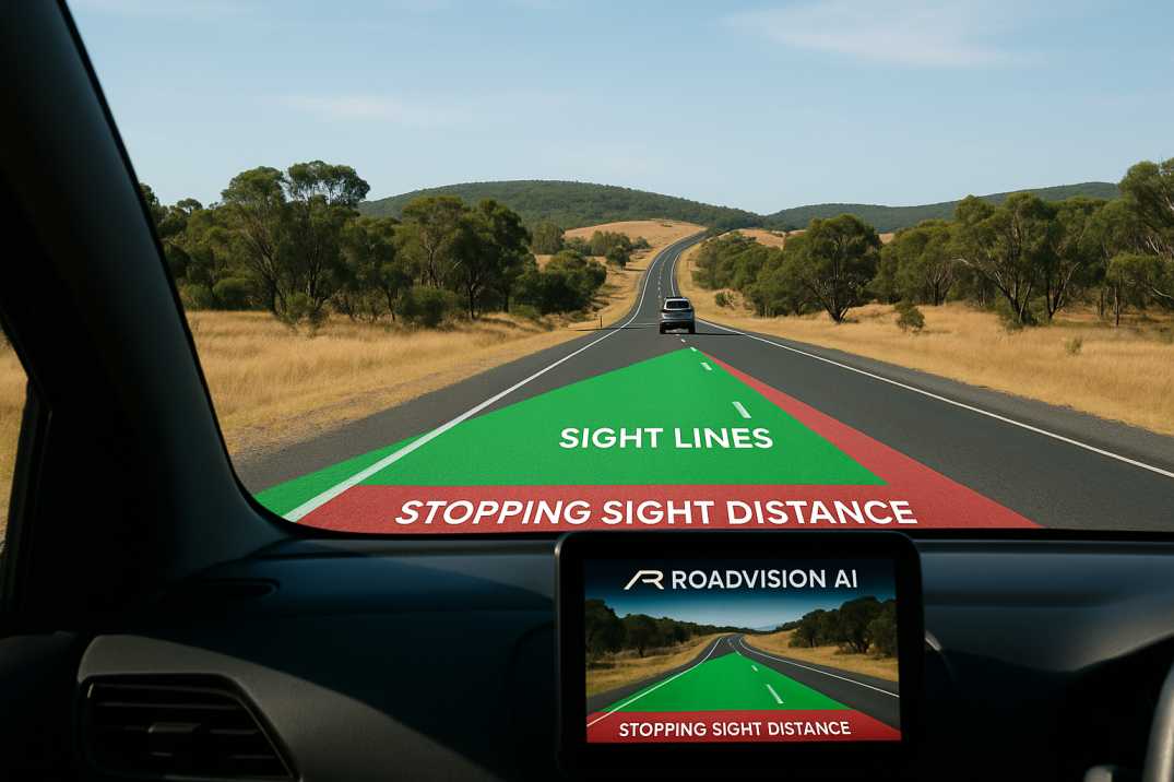
Today, digital transformation in asset management—driven by AI platforms such as RoadVision AI—is reshaping how engineers verify sight distance on both new and existing roads. What once required manual surveying and subjective judgement can now be validated objectively, automatically, and at scale.
Sight distance represents the length of roadway visible to a driver at any point along the carriageway. It dictates how quickly a driver can perceive, react, and respond to hazards. Under the Austroads Guide to Road Design, several sight distance types must be checked rigorously:
These are influenced by:
When these criteria are not met, risk escalates quickly—especially on rural roads, narrow formations, floodways, sharp horizontal curves, and vertical crests where visibility can drop without warning.
As Austroads notes, while Extended Design Domain (EDD) values can occasionally be used, they must be applied sparingly and only with technical justification.
Although this article references Austroads primarily, the underlying philosophies align closely with the principles defined in Indian Roads Congress (IRC) geometric design manuals.
Key principles include:
2.1 Human Factors Drive Sight Distance Values
Both Austroads and IRC assume realistic driver reaction times, deceleration rates, and eye-height parameters to determine sight distance envelopes that reflect actual driver behavior.
2.2 Geometry Must Support Operating Speed
Sight distance must match the operating speed, not merely the posted speed. On curves and crests, restricted visibility can mislead drivers and trigger high-severity crashes when actual speeds exceed design assumptions.
2.3 No Compromise at Intersections
Intersection sight triangles must remain unobstructed—whether by vegetation, poor earthworks, or built structures—to allow safe gap acceptance and turning maneuvers.
2.4 Consistency is Non-Negotiable
Both standards emphasise uniformity along a corridor so drivers are not surprised by sudden drops in visibility that violate their expectancy.
These principles form the backbone of compliance, safety, and design certification across Australia and India.
AI-driven road inspection introduces unprecedented precision and repeatability into sight-distance verification. The Road Safety Audit Agent operationalises best practices through:
3.1 Automated Sight Line Modelling
3.2 Digital Highway Audits Aligned to Austroads & IRC
3.3 Live GIS & Digital Twin Overlays
3.4 Data-Driven Compliance Reporting
In essence, RoadVision AI removes the guesswork, letting engineers focus on solutions—not measurements.
Despite clear standards, real-world road networks often fall short. Common challenges include:
4.1 Legacy Roads Built Under Older Codes
Many rural and regional roads were not constructed to contemporary Austroads or IRC principles, with sight distances that no longer meet modern safety expectations.
4.2 Vegetation Growth & Roadside Encroachments
Even compliant designs can lose sight distance over time as vegetation matures, signs are added, or structures encroach on sight triangles.
4.3 High Cost and Subjectivity of Manual Surveys
Traditional methods rely on limited sample points and human judgement, missing critical segments where visibility is marginal but not obviously deficient.
4.4 Rapidly Changing Traffic Speeds
As operating speeds increase due to vehicle improvements and road upgrades, historic sight distance provisions become inadequate for actual travel speeds.
4.5 Topography & Land Acquisition Constraints
In hilly, forested, or constrained corridors, achieving ideal geometry is often impractical, requiring careful risk assessment and mitigation.
This is where AI becomes the "bridge over troubled water," enabling agencies to keep roads compliant without ballooning budgets.
Sight distance might sound like a simple geometric variable, but it is the beating heart of road safety. Whether on a sweeping rural highway or a congested urban corridor, ensuring visibility is non-negotiable—and non-compliance can be costly, risky, and difficult to detect without the right tools.
As the proverb goes, "Forewarned is forearmed." AI enables exactly that: continuous visibility into invisible risks.
Platforms like RoadVision AI are ushering in a new era where:
If you're ready to replace manual uncertainty with AI-driven clarity, RoadVision AI offers a smarter, safer, and more defensible way to monitor and verify sight distance across entire road networks.
Curious to see how effortlessly your roads can achieve compliance? Book a demo with RoadVision AI today and experience the future of road safety audits firsthand.
Q1. What is the minimum sight distance in road design?
It depends on design speed, road gradient, and type of maneuver. Austroads provides specific SSD, ISD, and OSD values based on these parameters.
Q2. How does AI calculate sight distance?
AI systems use video and lidar inputs to simulate driver vision and detect line-of-sight constraints over road geometry.
Q3. Is AI inspection approved under Austroads guidelines?
AI outputs can be used to support design reviews, digital audits, and are increasingly accepted in road safety verification processes.

The Autonomous Road Engineer
AI that is transforming road infrastructure, from reactive to predictive.
.webp)
.webp)
.png)