In today's rapidly evolving transport landscape, road asset management in Australia demands precision, efficiency, and full situational awareness. Sight distance—one of the most fundamental factors in roadway safety—has traditionally been assessed through manual surveys and subjective field judgments. But as networks expand and safety expectations rise, such approaches no longer keep pace with operational demands.
Thanks to AI-based highway inspection systems and modern digital highway monitoring system solutions, sight distance analysis has entered a new era. These technologies enable engineers, road agencies, and consultants to achieve evidence-based, real-time visibility modelling across entire networks—helping Australia strengthen its position as a global leader in data-driven transport engineering.
As the old saying goes, "See the road clearly, and you steer the future safely." AI is making that clearer than ever.
Sight distance refers to the length of road visible to a driver under normal operating conditions. It directly influences stopping performance, overtaking opportunities, intersection safety, and compliance with geometric design standards such as those published by Austroads.
The major sight distance classifications include:
1.1 Stopping Sight Distance (SSD)
The minimum distance needed for a driver to perceive an object, react, and stop safely. AI improves SSD assessment through the Road Safety Audit Agent by continuously analysing gradients, horizontal curvature, road surface conditions, and obstruction zones—delivering more precise and consistent data than manual processes.
1.2 Approach Sight Distance (ASD)
Critical for intersection safety and decision-making. AI captures real-world visibility under changing lighting, weather, and traffic conditions, ensuring no visibility gaps go unnoticed.
1.3 Safe Intersection Sight Distance (SISD)
Vital for unsignalised intersections. AI-powered inspections through the Road Safety Audit Agent detect vegetation overgrowth, misaligned signage, roadside barriers, and shoulder defects that could compromise visibility.
1.4 Overtaking Sight Distance (OSD)
Essential for two-lane rural roads where passing manoeuvres require clear visibility of oncoming traffic. AI models simulate overtaking opportunities based on actual road geometry and traffic conditions.
1.5 Decision Sight Distance (DSD)
Additional distance required for complex decision-making at interchanges and high-stress locations.
Just as Indian Roads Congress emphasises data-backed sight distance compliance in its methodologies, Australia's engineering community is now turning to AI to enhance geometric design accuracy and safety outcomes.
2.1 Increased Crash Risk
2.2 Driver Behaviour Issues
2.3 Operational Impacts
Traditional visibility assessments rely on manual surveying, infrequent inspections, and subjective judgment. AI transforms this into a systematic, repeatable, and high-resolution process.
3.1 Automated, High-Precision Measurement
AI through the Road Safety Audit Agent uses video analytics, LiDAR, and 3D modelling to calculate SSD, ASD, and SISD with millimetre accuracy—removing human variability and ensuring unmatched consistency.
3.2 Continuous Network-Wide Monitoring
Roadside environments change daily due to vegetation growth, maintenance works, or weather conditions. The Roadside Assets Inventory Agent updates visibility conditions continuously through digital highway monitoring, eliminating the lag caused by annual inspections.
3.3 Identifies Obstructions Humans Often Miss
AI picks up subtle but critical issues such as glare, micro-alignment shifts, narrow shoulders, and minor foliage encroachment that are often overlooked in manual assessments.
3.4 Fully Integrated Road Safety Audit Workflow
AI-generated visibility models through the Road Safety Audit Agent automatically flag safety hazards long before they translate into crash risks—aligning with proactive road safety strategies.
3.5 Roadside Asset Intelligence
Visibility is affected by more than geometry. The Roadside Assets Inventory Agent ensures barriers, boards, posts, and signs don't intrude into sight envelopes.
3.6 Predictive Road Management
AI forecasts future visibility loss based on environmental trends and past deterioration patterns—allowing agencies to "fix the roof before it starts raining."
3.7 Multi-Factor Analysis
AI simultaneously considers:
Borrowing from global best practices such as IRC guidance and Austroads geometric design standards, modern sight distance analysis follows these principles:
AI tools through the Road Safety Audit Agent ensure each step is quantifiable, transparent, and repeatable—removing guesswork and elevating design reliability.
5.1 Geometric Factors
5.2 Roadside Factors
5.3 Environmental Factors
5.4 Traffic Factors
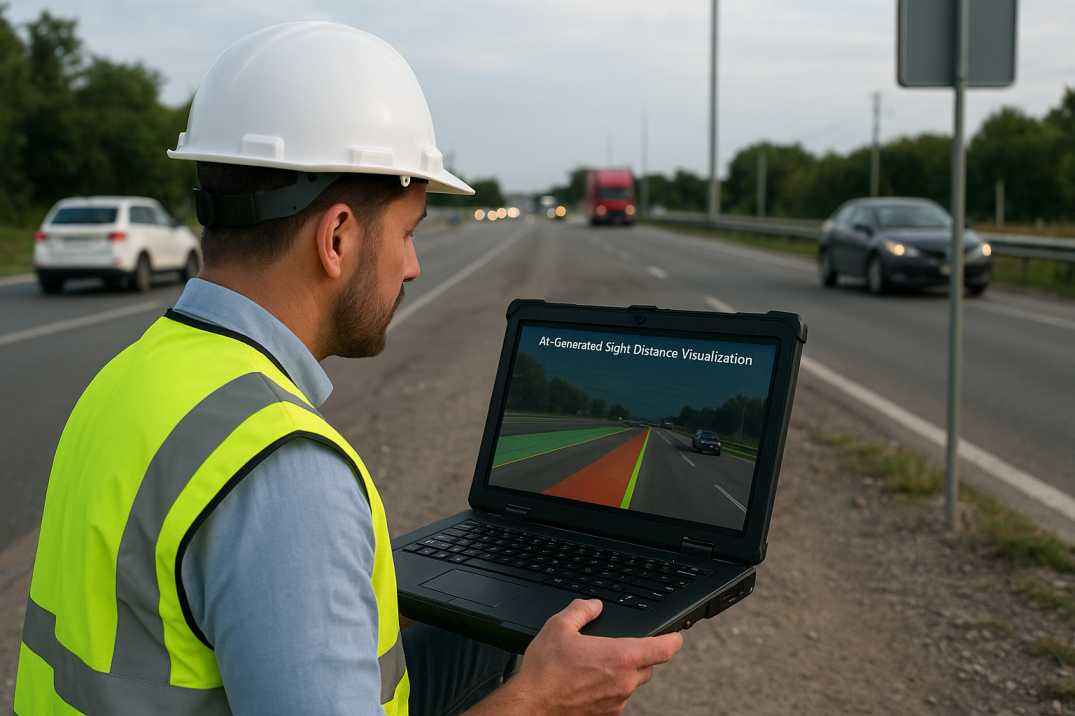
RoadVision AI elevates sight distance analysis through end-to-end automation, digital twins, and high-fidelity computer vision via its integrated suite of AI agents.
6.1 High-Resolution Visibility Mapping
The Road Safety Audit Agent captures roadway geometry, curvature, gradients, and roadside assets to produce accurate sight distance envelopes across entire corridors, identifying locations where visibility falls below standards.
6.2 Automated Hazard Detection
RoadVision AI flags:
6.3 AI-Enabled Road Safety Audits
The Road Safety Audit Agent produces automated compliance checks aligned with Austroads requirements and visibility design rules, generating priority lists for corrective action.
6.4 Predictive Visibility Analytics
RoadVision AI anticipates future issues—such as trees growing into sightlines or barriers requiring relocation—using growth rate models and deterioration forecasts.
6.5 Integrated Asset & Pavement Condition Intelligence
Sight distance data integrates seamlessly with pavement condition surveys through the Pavement Condition Intelligence Agent and asset inventory via the Roadside Assets Inventory Agent to present a holistic safety picture.
6.6 Night Visibility Assessment
AI simulates headlight illumination patterns to evaluate:
6.7 Dynamic Visibility Monitoring
For locations with changing conditions (e.g., seasonal vegetation, construction), AI provides continuous updates rather than static assessments.
When combined, these capabilities turn visibility assessment from a reactive task into a proactive safety strategy.
7.1 Vegetation Encroachment
7.2 Geometric Issues
7.3 Roadside Obstructions
7.4 Pavement-Related Issues
While AI delivers substantial benefits, implementation requires navigating certain challenges:
8.1 Data Integration Across Agencies
Transport authorities, councils, consultants, and contractors must harmonise large datasets for optimal results.
AI Solution: Centralized platforms through RoadVision AI ensure all stakeholders work from the same data.
8.2 Environmental Adaptation
Bright sunlight, shadows, weather, and regional vegetation require robust AI models tailored for Australian conditions.
AI Solution: Models trained on Australian conditions maintain accuracy across diverse environments.
8.3 Hardware Deployment & Connectivity
Remote highways need reliable data capture technologies and operational redundancy.
AI Solution: Edge processing with offline-first capabilities ensures functionality.
8.4 Skills and Training Requirements
Agencies must upskill teams to interpret AI-generated sightline models and integrate them into design workflows.
AI Solution: Comprehensive training programs ensure successful adoption.
8.5 Transition from Traditional Methods
Moving from periodic surveys to continuous digital monitoring requires organisational adaptation.
AI Solution: Phased implementation demonstrates ROI before full-scale deployment.
8.6 Vegetation Management Coordination
Vegetation growth requires coordination with land management agencies.
AI Solution: Automated alerts for vegetation clearing coordination.
Despite these challenges, the long-term safety, cost, and operational benefits far outweigh the transition effort—as the saying goes, "The proof of the pudding is in the eating."
9.1 For Design Engineers
9.2 For Road Authorities
9.3 For Road Users
AI is no longer a "nice addition" to sight distance analysis—it is a necessity. With unmatched accuracy, scalability, and alignment with Austroads and IRC Codes through the Road Safety Audit Agent, Pavement Condition Intelligence Agent, and Roadside Assets Inventory Agent, AI ensures Australian roads remain safe, resilient, and future-ready.
The platform's ability to:
transforms how sight distance is analysed across Australia's highway network.
RoadVision AI is at the forefront of this transformation. By integrating AI, digital twins, and automated road safety audits, it enables early detection of surface issues, enhances traffic survey accuracy through the Traffic Analysis Agent, optimises congestion management, and supports data-driven geometric design. The result is safer roads, reduced maintenance costs, and streamlined engineering decisions.
If you're ready to modernise visibility modelling, enhance safety audits, and embrace a new era of digital highway intelligence, book a demo with RoadVision AI today—because in road safety, "seeing ahead is winning ahead."
Q1. How does AI improve accuracy in sight distance analysis?
AI captures road geometry continuously and calculates visibility using automated algorithms, eliminating human subjectivity.
Q2. Can AI be used for both highways and rural roads?
Yes, AI-based inspection models work across all road categories, including highways, city roads, and regional routes.
Q3. Does AI support compliance with Australian road design standards?
AI systems are built to align with national design principles and ensure visibility parameters meet required safety thresholds.

The Autonomous Road Engineer
AI that is transforming road infrastructure, from reactive to predictive.
.webp)
.webp)
.png)