Highway 1, stretching more than 14,000 km, is the backbone of Australia's transport system. Connecting every mainland state capital, it supports freight, logistics, and regional mobility on an unprecedented scale. As Australia accelerates its shift toward autonomous transport and smart mobility, the nation faces an urgent question: How do we future-proof such a massive and diverse highway network?
With rising freight loads, weather-driven deterioration, and widespread safety blackspots, traditional monitoring methods simply cannot keep pace. This is why AI-powered road mapping and digital highway monitoring technologies are becoming indispensable—ensuring Highway 1 remains safe, resilient, and ready for autonomous vehicles.
As the Australian saying goes, "Fix it before it breaks," and AI does exactly that—predicting problems long before they become hazards.

Highway 1 is one of the world's most unique long-distance corridors, spanning deserts, coastal regions, and regional towns. Its scale presents challenges such as:
For autonomous vehicles to operate safely, the road environment must be predictable, well-mapped, and continuously updated. This is where AI road mapping, digital twins, and real-time condition monitoring through the Pavement Condition Intelligence Agent and Roadside Assets Inventory Agent fundamentally transform Highway 1's future.
Even though Australia follows Austroads guidelines rather than IRC codes, the underlying engineering principles remain universal. Preparing Highway 1 for autonomous vehicles requires adherence to critical road safety and performance concepts:
2.1 High-Precision Road Mapping
Autonomous systems rely on lane markings, geometry, road edges, signage, and surface texture. AI enables centimetre-level capture of this data through the Roadside Assets Inventory Agent.
2.2 Digital Twins for Predictive Mobility
AI models create virtual replicas of Highway 1, supporting simulation, risk assessment, and autonomous vehicle testing under various scenarios.
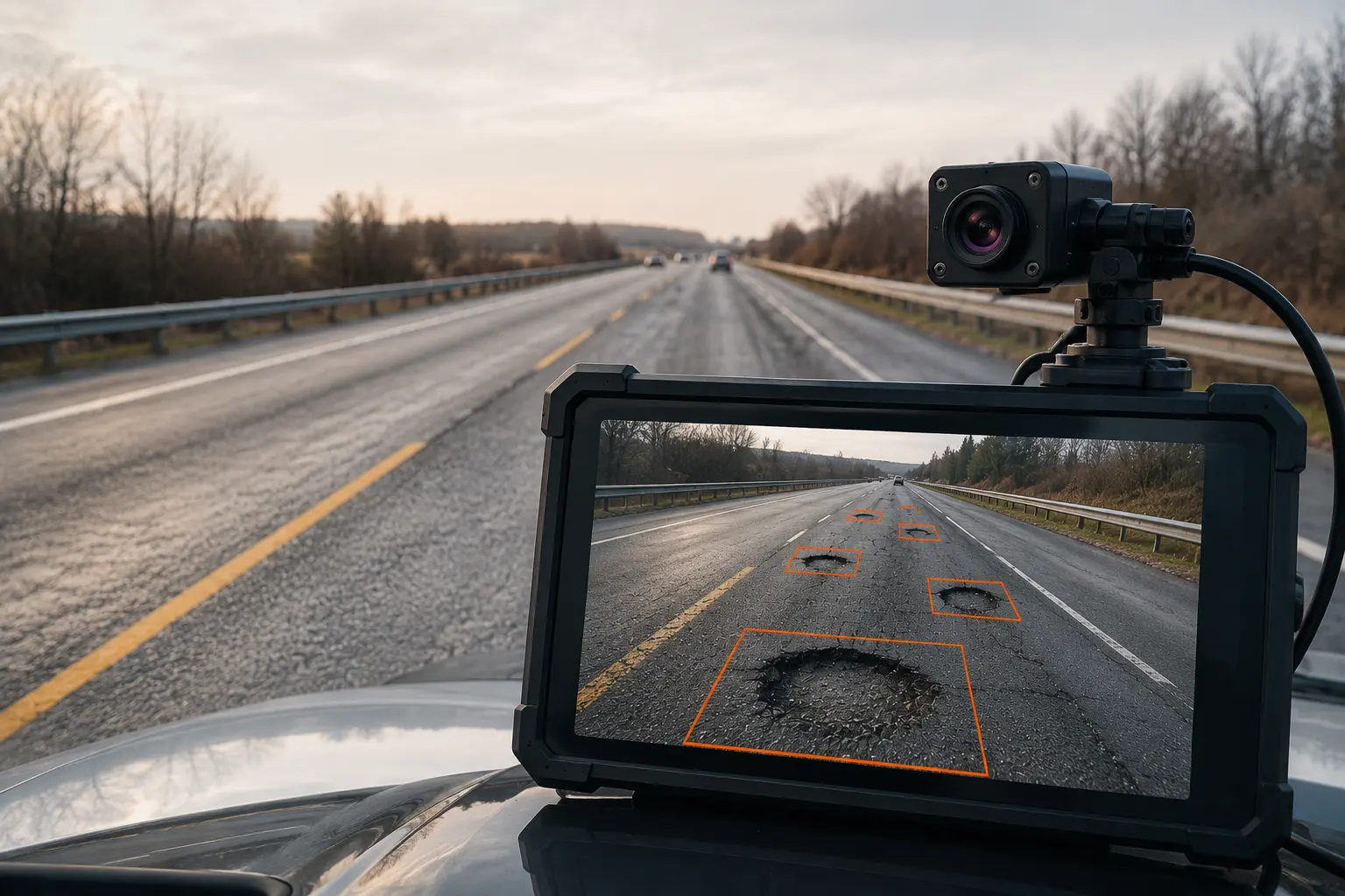
2.3 Continuous Pavement Condition Assessment
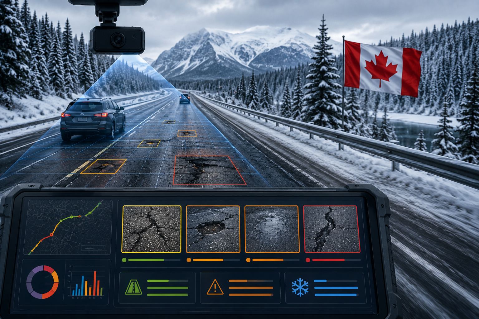
Machine-vision tools through the Pavement Condition Intelligence Agent identify potholes, cracks, rutting, and texture loss—key risks for both human and automated driving.
2.4 Compliance with Austroads Safety Framework
Digital audits through the Road Safety Audit Agent ensure alignment with sight-distance standards, curve geometry, and roadside hazard controls.
2.5 Crash Pattern Analysis & Intervention Design
The Traffic Analysis Agent identifies root causes of Highway 1 blackspots, supporting targeted engineering treatments.
2.6 Predictive Maintenance Modelling
Long-term deterioration forecasting through the Pavement Condition Intelligence Agent supports budget optimisation for large and remote segments.
These principles underpin the shift from reactive highway maintenance to proactive, data-driven asset management across Australia.
Autonomous vehicles require:
3.1 Clear Lane Markings
AVs depend on visible, well-maintained lane markings for positioning. The Roadside Assets Inventory Agent monitors marking condition and retroreflectivity.
3.2 Accurate Signage
Traffic signs must be legible and correctly positioned for AV sensors to interpret. AI audits identify deficiencies.
3.3 Consistent Geometry
Curve radii, gradients, and superelevation must be within predictable ranges. The Road Safety Audit Agent verifies geometric consistency.
3.4 Updated Digital Maps
AV navigation requires continuously updated high-definition maps that reflect real-world conditions.
3.5 Predictable Surface Conditions
Potholes, rutting, and surface texture variations affect AV control systems. The Pavement Condition Intelligence Agent monitors these continuously.
5.1 Pacific Highway (Brisbane to Sydney)
High-traffic coastal corridor requiring continuous monitoring for lane markings and pavement condition under heavy tourist and freight loads.
5.2 Princes Highway (Sydney to Melbourne via coast)
Scenic route with variable geometry requiring detailed mapping for AV navigation.
5.3 Hume Highway (Sydney to Melbourne)
Inland freight corridor with high heavy vehicle proportions requiring structural monitoring through the Pavement Condition Intelligence Agent.
5.4 Eyre Highway (Port Augusta to Norseman)
Remote desert crossing with long distances between services, requiring predictive maintenance for uninterrupted operation.
5.5 Great Northern Highway (Perth to Wyndham)
North-west corridor serving mining and agricultural industries with extreme climatic variations.
5.6 Stuart Highway (Darwin to Port Augusta)
Central corridor connecting north and south, with remote sections requiring automated monitoring.
RoadVision AI brings an advanced suite of digital tools tailored for Australia's road conditions. Its systems combine AI, computer vision, and digital twins through its integrated suite of AI agents to support authorities in building autonomous-ready road networks.
How RoadVision AI Applies These Principles:
6.1 AI Road Mapping
The Roadside Assets Inventory Agent uses high-resolution cameras and sensors to generate digital maps with precise geometry and inventory data—essential for AV navigation.
6.2 Pavement Condition Surveys
The Pavement Condition Intelligence Agent provides automated detection of cracks, potholes, ravelling, and surface failures, ensuring Highway 1 stays within Austroads performance thresholds.
6.3 Road Safety Audits (AI-enabled)
The Road Safety Audit Agent highlights high-risk curves, visibility issues, roadside hazards, and worn markings that could confuse AV sensors.
6.4 Crash Analysis & Blackspot Identification
AI models evaluate historical crash data through the Traffic Analysis Agent to forecast high-risk segments and propose engineering remedies.
6.5 Predictive Maintenance Modelling
Long-term deterioration forecasting through the Pavement Condition Intelligence Agent supports budget optimisation for large and remote segments of Highway 1.
6.6 Real-Time Condition Updates
Continuous monitoring ensures digital maps reflect current conditions, essential for AV navigation systems.
By integrating all these functions into one unified platform, RoadVision AI provides authorities with faster, more accurate, and cost-efficient decision-making.
Transforming a 14,000-km corridor is no small task. Key challenges include:
7.1 Environmental Extremes
Heatwaves, coastal humidity, heavy rainfall, and outback conditions create complex deterioration patterns that require advanced modelling through the Pavement Condition Intelligence Agent.
7.2 Sheer Geographic Scale
Covering multiple states and jurisdictions makes standardised condition monitoring difficult without digital automation.
7.3 Data Integration Across Agencies
Coordinating transport departments, local councils, and contractors requires unified platforms and shared digital standards.
7.4 AV-Readiness Requirements
Autonomous vehicles demand incredibly accurate mapping, flawless lane markings, and continuous updates—requiring ongoing digital investment.
7.5 Funding Consistency
Long-term investment across multiple budget cycles is essential for sustained improvement.
7.6 Technology Evolution
AV technology continues to evolve, requiring flexible systems that can adapt to changing requirements.
RoadVision AI's automated, cloud-based tools help reduce many of these barriers, ensuring high-quality, scalable implementation.
Highway 1 is more than just a long road—it is Australia's national lifeline. Preparing it for autonomous vehicles requires innovation, precision, and continuous monitoring. AI-based road mapping, digital twins, crash analytics, and predictive maintenance through the Pavement Condition Intelligence Agent, Traffic Analysis Agent, Road Safety Audit Agent, and Roadside Assets Inventory Agent are transforming how this iconic highway is managed.
The platform's ability to:
ensures that Highway 1 can evolve to meet the demands of autonomous transport.
As the saying goes, "The future doesn't wait," and Australia must build highways ready for the next generation of transport. The investment in AI-powered monitoring today will pay dividends in safety, efficiency, and mobility for decades to come.
RoadVision AI is leading this transformation by:
With these innovations, Highway 1 is well on its way to becoming an intelligent, autonomous-vehicle-ready corridor that sets the standard for long-distance highway management worldwide.
To discover how RoadVision AI can optimise Highway 1 and other Australian road networks for the autonomous era, book a demo with RoadVision AI today.
Q1. How can AI improve safety on Highway 1 Australia?
AI can identify high-risk zones, predict accidents through crash analysis, and support road safety audits, reducing fatalities and injuries.
Q2. Why is AI road mapping important for autonomous vehicles?
Accurate AI road mapping creates digital twins of highways, providing autonomous vehicles with reliable, updated data for safe navigation.
Q3. What is the role of AI in road asset management Australia?
AI enhances asset management by automating inspections, monitoring pavement conditions, and enabling predictive maintenance for long-term savings.

The Autonomous Road Engineer
AI that is transforming road infrastructure, from reactive to predictive.
.webp)