Urban mobility across Africa is reaching a critical juncture. Rapid population growth, rising vehicle ownership, and accelerated urbanisation have pushed city transport networks to their limits. Congestion, unpredictable travel times, and safety hazards are daily challenges for millions.
To move forward, African cities must shift from traditional, labour-intensive traffic surveys toward digital traffic monitoring systems, AI-based traffic analytics, and smart mobility solutions. As the proverb goes, "You cannot manage what you cannot measure." In mobility, precise measurement is the foundation for progress.
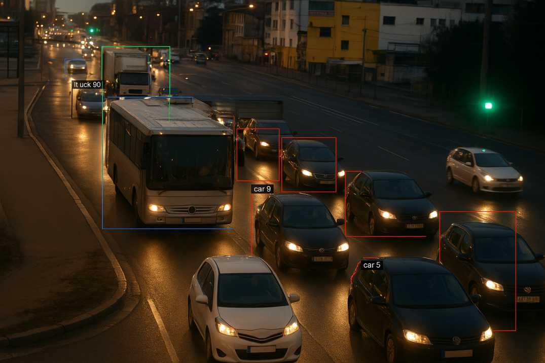
Traditional manual traffic counts—often clipboards, tally marks, and short observation windows—cannot keep pace with the speed at which African urban environments are changing. Without real-time insights, infrastructure investment becomes reactive, slow, and often misaligned with actual needs.
Key challenges include:
African governments now recognise the need for AI-powered, continuous, and reliable mobility intelligence.
While African nations use their own regulatory systems, many infrastructure planning processes align conceptually with global best practices—similar to principles outlined by the Indian Roads Congress, which emphasise:
2.1 Data-Driven Mobility Planning
Reliable, continuous traffic data should guide design decisions, traffic signal planning, and road capacity calculations. The Traffic Analysis Agent provides this foundation.
2.2 Road Safety Integration
Traffic monitoring must support safety audits, risk assessments, and interventions to minimise accident hotspots through the Road Safety Audit Agent.
2.3 Predictive Maintenance and Asset Health
Understanding how traffic loads impact pavement deterioration through the Pavement Condition Intelligence Agent is essential for long-term road management.
2.4 Standards for Survey Quality and Accuracy
Traffic studies should minimise human error and adhere to reproducible methodologies—something digital tools naturally enable.
2.5 Multi-Modal Integration
Systems must account for all road users including pedestrians, cyclists, and public transport.
These principles align perfectly with Africa's move toward AI-driven mobility intelligence.
A digital traffic survey replaces manual counting with:
Unlike periodic manual surveys that provide snapshots, digital surveys deliver continuous, real-time insights—a game changer for cities facing rapid urban mobility shifts.
4.1 Real-Time Congestion Prediction
The Traffic Analysis Agent uses AI models to analyse live streams of traffic data and predict congestion before it forms. Authorities can:
4.2 Improved Road Safety
By integrating road safety audits through the Road Safety Audit Agent, AI systems pinpoint:
Early insights enable timely interventions that save lives—critical in regions where road fatality rates remain high.
4.3 Smarter Infrastructure Planning
AI enhances planning by combining traffic flow insights with:
This ensures roadworks are scheduled strategically—minimising disruption in already congested corridors.
4.4 Cost Efficiency for Governments
Predictive analytics reduce:
For budget-limited African municipalities, every saving counts.
4.5 Public Transport Optimisation
Digital traffic data enables:
4.6 Non-Motorised Transport Planning
AI systems track pedestrian and cyclist movements, supporting:
5.1 Lagos, Nigeria
Africa's largest city faces extreme congestion. Digital traffic surveys support BRT corridor optimisation, bridge approach monitoring, and port access route management.
5.2 Nairobi, Kenya
With its matatu paratransit system and growing suburbs, Nairobi benefits from AI analysis of complex traffic patterns and informal transport behaviour.
5.3 Johannesburg, South Africa
South Africa's economic hub uses digital traffic data for freeway management, toll route monitoring, and integrated transport planning.
5.4 Accra, Ghana
Rapid urbanisation in Accra demands continuous traffic monitoring for infrastructure investment prioritisation and congestion management.
5.5 Kigali, Rwanda
Kigali's organised approach to urban development makes it ideal for integrating AI traffic systems with smart city initiatives.
5.6 Addis Ababa, Ethiopia
With its light rail and BRT systems, Addis requires sophisticated traffic data for multi-modal integration.
RoadVision AI brings global engineering intelligence into the African context, enabling cities to leapfrog outdated methods and adopt future-ready mobility systems through its integrated suite of AI agents.
6.1 Advanced Digital Traffic Surveys
The Traffic Analysis Agent provides real-time data on:
—far more accurate and comprehensive than traditional manual counts.
6.2 Integrated Mobility Intelligence
RoadVision AI combines traffic analytics with:
—offering a holistic view of urban mobility.
6.3 Automated Road Safety Audits
Computer-vision tools detect:
6.4 Predictive Maintenance in High-Traffic Zones
By analysing load distribution and traffic density, RoadVision AI helps authorities:
—"fixing problems before they become potholes."
6.5 Scalability for African Cities
Whether in Lagos, Nairobi, Accra, Kigali, or Johannesburg, the platform can adapt to:
6.6 Capacity Building and Training
The platform includes:
Despite clear benefits, several challenges persist:
7.1 Infrastructure Gaps
Some cities lack stable power, fibre networks, or sensor-ready intersections for continuous monitoring.
AI Solution: Solar-powered options and cellular connectivity enable deployment even where infrastructure is limited.
7.2 Budget Constraints
Although cost-effective long term, AI systems require initial investment that may strain municipal budgets.
AI Solution: Phased deployment allows cities to start with pilot projects and scale based on demonstrated ROI.
7.3 Skills and Training Needs
Traffic authorities must be trained to interpret and utilise AI-generated insights effectively.
AI Solution: Comprehensive training programmes and intuitive interfaces ensure successful adoption.
7.4 Data Governance
Cities need frameworks for secure data storage, access, and transparency to maintain public trust.
AI Solution: Built-in data governance tools ensure compliance with local regulations.
7.5 Mixed Traffic Complexity
African cities often have highly heterogeneous traffic with informal transport modes that challenge standard algorithms.
AI Solution: Models trained on local conditions account for diverse vehicle types and behaviours.
7.6 Rapid Urbanisation
Fast-changing urban landscapes require adaptable systems that can keep pace with development.
AI Solution: Continuous monitoring ensures data remains current as cities evolve.
Addressing these challenges through platforms like RoadVision AI will ensure long-term success of AI-driven mobility programs.
Adopting digital traffic systems can transform African urban mobility by enabling:
In essence, smarter mobility directly contributes to stronger cities and improved quality of life for millions of Africans.
Africa's urban centres are evolving rapidly, and the old tools of traffic planning can no longer keep pace. Digital traffic surveys and AI-powered monitoring through the Traffic Analysis Agent, Road Safety Audit Agent, Pavement Condition Intelligence Agent, and Roadside Assets Inventory Agent represent the next leap forward—more accurate, more efficient, and more aligned with the continent's long-term development goals.
RoadVision AI is leading this transformation by delivering end-to-end traffic intelligence solutions. With compliance aligned to IRC principles and international standards, RoadVision AI equips engineers and city planners with actionable, data-driven insights that reduce costs, minimise risks, and create safer, smarter cities.
The platform's ability to:
ensures that African cities can leapfrog outdated methods and embrace future-ready mobility systems.
As the African proverb says, "A bridge is built with stones; a city is built with knowledge." AI is that knowledge—turning information into impact that transforms how people move, work, and live in Africa's growing urban centres.
Book a demo with RoadVision AI today to see how digital traffic surveys can help your city adopt next-generation traffic monitoring and reshape the future of African mobility.
Q1: What is an AI traffic survey?
An AI traffic survey uses digital tools such as sensors and cameras to collect real-time traffic data, improving accuracy compared to manual surveys.
Q2: How does digital traffic monitoring benefit African cities?
It reduces congestion, improves safety, and ensures better infrastructure planning by providing continuous and reliable data.
Q3: Why should African governments invest in AI traffic management systems?
They lower long-term costs, improve commuter safety, and create smarter cities with sustainable mobility solutions.

The Autonomous Road Engineer
AI that is transforming road infrastructure, from reactive to predictive.
.webp)
.webp)
.png)