India's road network—spanning over 6.3 million kilometres—is the backbone of economic growth and daily mobility. Yet maintaining this vast network remains one of the toughest challenges for local governments. Traditional manual inspections are slow, labour-intensive, costly, and often inconsistent due to human subjectivity. When "time is money," delayed inspections translate into delayed maintenance, higher costs, and deteriorating road safety.
Mobile-based road condition data collection, powered by AI-driven pavement monitoring technologies, is emerging as a game changer. These systems enable municipalities to collect large-scale pavement data quickly, accurately, and in line with Indian Roads Congress (IRC) guidelines such as IRC SP:16, IRC SP:21, and IRC:82.
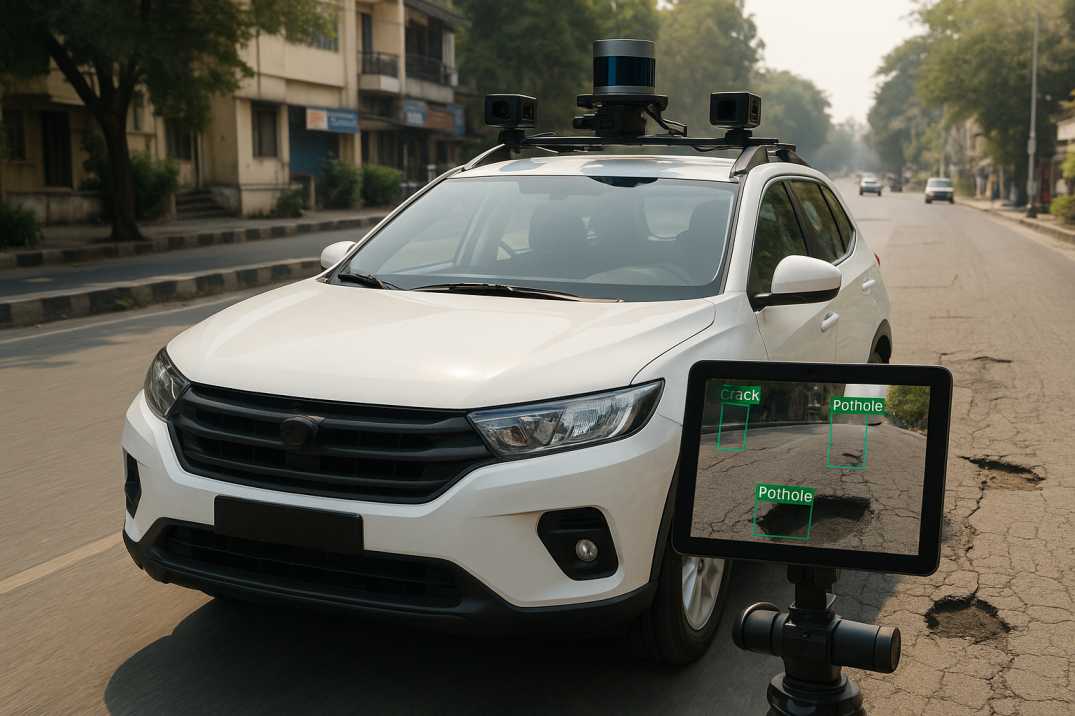
RoadVision AI brings these innovations together—delivering an accessible, scalable, and cost-effective system for modern urban road management.
For local governments dealing with tight budgets and vast road networks, traditional survey methods simply do not scale. Mobile-based systems, built using smartphones or compact sensors, offer major advantages:
As the saying goes, "a stitch in time saves nine"—and mobile-based monitoring ensures those stitches happen before roads deteriorate beyond repair.
While the U.S. often references the Federal Highway Administration, pavement condition surveys in India must adhere to IRC's structured guidelines such as:
2.1 IRC SP:16 – Guidelines for Surface Evenness of Highways
Focuses on:
2.2 IRC SP:21 – Manual for Maintenance of Bituminous Surfaces
Specifies inspection of:
2.3 IRC:82 – Code of Practice for Maintenance of Bituminous Roads
Supports:
Local governments must meet these standards to ensure safety, optimize public expenditure, and maintain compliance with national pavement maintenance protocols.
RoadVision AI integrates AI, computer vision, and mobile mapping into a seamless road condition monitoring ecosystem through its integrated suite of AI agents. Key best practices include:
3.1 AI-Based Pavement Distress Detection
The Pavement Condition Intelligence Agent uses smartphone-mounted cameras and sensors to capture continuous road imagery and vibration data. AI models automatically detect:
This fully eliminates subjective field evaluations and ensures consistent results across different inspectors and time periods.
3.2 Automated Roughness & IRI Estimation
Using accelerometer and gyroscope data from standard smartphones, RoadVision AI estimates:
Results align with IRC SP:16 requirements, providing objective ride quality data without specialized profilometers.
3.3 Road Inventory Capture
Beyond pavement defects, the Roadside Assets Inventory Agent documents:
All assets are geotagged with precise coordinates within a GIS-based digital road maintenance platform, creating a comprehensive asset register.
3.4 Predictive Maintenance Recommendations
AI models forecast deterioration trends based on:
This helps municipalities schedule timely interventions rather than firefighting after damage occurs—"fixing the roof while the sun is shining."
3.5 Integration with Digital Road Maintenance Systems
All processed data feeds into RoadVision AI's digital maintenance dashboard:
This ensures end-to-end asset lifecycle visibility and supports evidence-based decision-making.
3.6 Compliance-Ready Reporting
The platform generates reports aligned with IRC formats:
3.7 Scalable Deployment
The system can be deployed on:
This flexibility ensures even resource-constrained municipalities can implement comprehensive monitoring programs.
Despite the clear benefits, adoption of modern monitoring systems faces several challenges:
4.1 Limited Technical Expertise
Smaller municipalities sometimes lack skilled personnel to manage advanced tools and interpret AI-generated insights.
AI Solution: User-friendly dashboards and automated recommendations minimize the need for specialized expertise.
4.2 Funding Constraints
Budget allocations for technology upgrades may be limited, especially in smaller urban local bodies.
AI Solution: Low-cost smartphone-based systems eliminate the need for expensive survey vehicles, making technology accessible to all.
4.3 Inconsistent Data Practices
Lack of standardized inspection routines can lead to fragmented datasets that are difficult to compare over time.
AI Solution: Automated, repeatable surveys ensure consistent data collection regardless of who performs the survey.
4.4 Vast Coverage Needs
Urban local bodies often manage thousands of kilometres with limited staff, making comprehensive manual surveys impossible.
AI Solution: High-speed mobile surveys cover networks efficiently, with 200-300 km per day per vehicle.
4.5 Legacy Systems
Conventional workflows may not support digital transformation initiatives or integration with modern platforms.
AI Solution: Flexible export options and APIs enable gradual integration with existing systems.
4.6 Data Quality Concerns
Municipalities may question the accuracy of smartphone-based data compared to specialized equipment.
AI Solution: Extensive validation studies demonstrate accuracy comparable to specialized profilers while providing additional distress data they cannot capture.
Mobile-based systems like RoadVision AI are specifically designed to overcome these barriers—requiring minimal hardware, low training effort, and high scalability.
Mobile-based road condition monitoring is poised to become the gold standard for road asset management in India. Powered by AI, GIS integration, and predictive analytics through the Pavement Condition Intelligence Agent, Roadside Assets Inventory Agent, Road Safety Audit Agent, and Traffic Analysis Agent, these systems enable local governments to:
The platform's ability to transform standard smartphones into powerful road assessment tools democratizes access to advanced infrastructure intelligence. Every municipality, regardless of size or budget, can now implement world-class road condition monitoring.
As the saying goes, "the proof of the pudding is in the eating," and RoadVision AI demonstrates its value through transparent analytics, actionable insights, and real-world results achieved by early-adopting municipalities across India.
If your municipality is ready to embrace smarter, safer, and more sustainable road maintenance, RoadVision AI provides the tools to make it happen. Book a demo with RoadVision AI today and discover how mobile-based monitoring can transform your approach to road asset management.
Q1: How often should road condition monitoring be done in India?
As per IRC SP:16, highways should be surveyed annually, while urban roads should be inspected every 6 months for optimal maintenance planning.
Q2: Is mobile-based monitoring accurate enough for official reports?
Yes, when calibrated and compliant with IRC guidelines, mobile-based systems produce data suitable for government-level pavement management reports.
Q3: Can AI pavement condition monitoring predict future road damage?
Yes, AI models can use historical and real-time data to forecast pavement deterioration trends, enabling preventive maintenance.

The Autonomous Road Engineer
AI that is transforming road infrastructure, from reactive to predictive.
.webp)
.webp)
.png)