Visakhapatnam is Andhra Pradesh's largest city and one of India's most critical port hubs — a coastal metropolis whose road network underpins daily mobility for millions of residents, commuters, and freight operators. GVMC managed this network the way most Indian municipal corporations do: through complaint registers, field memory, and periodic visual surveys that produced inconsistent, non-comparable, and fully unauditable outputs.
Without a standardised condition record, every maintenance decision was a judgement call. There was no mechanism to compare one corridor against another — or to track whether the network was improving or deteriorating over time. AI-based pavement condition monitoring was absent entirely.
Without a GPS-verified pre-repair baseline, contractors could deliver minimum visible compliance. No department could objectively verify whether work met quality standards. A road asset management system with pre/post capability was needed.
The budget followed complaints, not condition severity. High-priority corridors near freight routes went underfunded while visibly potholed roads received disproportionate attention — a direct consequence of having no automated pavement distress detection infrastructure.
Faded road markings, missing signage, damaged crash barriers, and drainage failures went untracked between complaint cycles. Without a digital safety audit platform, GVMC had no way to proactively identify safety-critical deficiencies across its network.

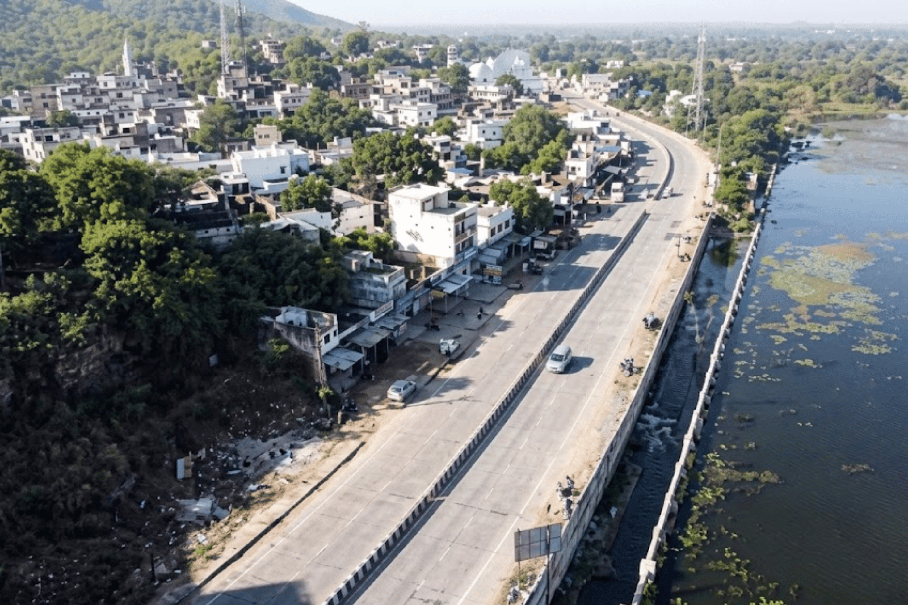
GVMC partnered with RoadVision AI to conduct a pilot covering 42.54 kilometres of key corridors across Visakhapatnam. The mandate: demonstrate AI pavement inspection at scale, identify defects with precision, and deliver outputs engineering teams could act on immediately — without road closures, specialist equipment, or weeks of mobilisation.
Survey vehicles fitted with the RoadVision AI data collection app and a suction windshield mount drove Visakhapatnam's corridors at regular traffic speed — including Sampath Vinayaka Temple Road, Waltair Station Approach Road, and Scindia Road. The app captured high-resolution video, images, and GPS coordinates continuously. Zero lane closures. Zero specialist mobilisation. Zero disruption to port freight movement.
Collected footage was processed through RoadVision AI's intelligence platform. The platform automatically identified road types, classified conditions and distresses in line with IRC guidelines, detected signage compliance, and built digital twins of surveyed corridors. No human annotation. Full automated pavement distress detection across every frame.

Every detected defect was GPS-pinned to its exact 100-metre chainage segment. The AI computed an IRC Pavement Condition Index score — from 0 (complete failure) to 100 (perfect) — per segment. Every corridor received a defensible, auditable score. This is what pavement analysis software built for governance looks like in practice.
Results were published simultaneously to a live GIS cloud platform and compiled into IRC-compliant PDF and CSV reports. Both outputs were ready within hours of processing completion. The platform functions as a live road asset management system from day one.
The pilot revealed a network under significant structural stress. The AI road condition analysis engine detected and catalogued 3,955 individual defects across 42.54 kilometres — each classified by type, severity, and precise GPS location. Ravelling dominated the distress profile: over 3,163 instances — a systemic signal, not isolated incidents.
Ravelling — the progressive loss of aggregate and binder from the pavement surface — accounted for more than 3,163 of the 3,955 defects detected. This is not routine wear; it is an early-stage structural signal that, left unaddressed, accelerates into potholing, cracking, and full-depth failure requiring costly reconstruction rather than cost-effective preventive treatment.
Sampath Vinayaka Temple Road, Waltair Station Approach Road, and Scindia Road each received individual segment scores and distress breakdowns — enabling corridor-level prioritisation that GVMC had never had access to.
"Ravelling alone accounted for over 3,163 instances — a systemic signal, not isolated incidents. Early detection is where AI-based pavement condition monitoring creates compounding value over time."
Every metre of every assessed corridor is preserved as video — both the original dashcam capture and the AI-processed version with every detected defect marked in real time. This library is GVMC's permanently accessible, timestamped evidence record — the foundation of any serious digital safety audit platform.
Original dashcam footage from every surveyed corridor, organised by road name and survey date. Every frame is GPS-timestamped and permanently accessible — it never expires from the platform.
The same footage with every detected distress highlighted — bounding boxes, classification labels, severity ratings, and GPS coordinates overlaid in real time as GVMC engineers review. The evidence layer for any AI road safety audit conversation.

Compare the same corridor across two survey dates — frame by frame. See exactly how surface conditions evolved, or verify independently whether a contractor repair was effective before payment is authorised.
Every assessed corridor gets a structured, permanent record in the platform — an IRC-scored condition register that forms the backbone of evidence-based maintenance planning and the primary input for any credible road asset management system in GVMC's governance framework.
Each assessed road is assigned a permanent Corridor ID. All future surveys map automatically to the same ID — creating a cumulative historical record that survives personnel changes, administrative reorganisations, and election cycles.
An automated IRC condition score from 0–100 per corridor and per 100-metre segment — computed by the pavement analysis software engine against Indian Roads Congress standards. Removes subjectivity. Gives every road a defensible, independently auditable rating.
Every defect carries a GPS-tagged photograph extracted from the survey footage — accessible in the corridor report and linked to its precise location on the GIS map. Downloadable in both PDF and Excel format.
Once a follow-up survey is conducted after repairs, the platform automatically compares IRC scores — showing exactly how each corridor has changed and providing the independent verification layer that makes contractor payment accountability possible.

Every defect is geospatially pinned. Every corridor segment is colour-coded by IRC condition severity — giving GVMC planners, engineers, and accountability officers an instant visual triage of the network. This is the smart city road safety solution layer that makes evidence-based governance visible.
Tap any defect marker on the map to instantly retrieve the survey photograph from that exact GPS location — with defect type, severity classification, and chainage reference.
Green, amber, and red segments tell the prioritisation story instantly — no data literacy required. Ward engineers, department heads, and audit officers read the same map the same way.
Isolate all ravelling instances above high severity. Filter to a specific ward's corridors. View only critical segments requiring immediate intervention.
Cloud-hosted and accessible to all authorised GVMC personnel — from the commissioner's office to field supervisors on smartphones — without any software installation.
The platform produces structured insight at four distinct levels of granularity — from a single defect instance to the full 42.54-kilometre network view. This is how AI road condition analysis becomes a governance asset rather than a technical report.
> Defect Level — Every Instance, Classified and Located
Each of the 3,955 detected defects carries a GPS coordinate, defect type, severity rating, surface extent measurement, and a photographic record. Engineers receive a structured, sortable defect inventory — not a general impression of a corridor's condition.
> Chainage Level — 100-Metre Segment Resolution
IRC condition scores per 100-metre segment reveal where within a corridor deterioration is concentrated — enabling surgical repair targeting rather than full-corridor resurfacing that wastes budget on already-functional sections.
> Corridor Level — Complete Profile and Formal Report
Comprehensive report per corridor — overall IRC PCI score, total defect count by type and severity, GPS-pinned photo documentation, IRC-referenced remedial recommendations, and historical comparison across surveys. Designed for the road asset management system workflow. Available in PDF and Excel.
> Network Level — The Full City Picture
The network dashboard shows the health of the entire assessed system at once — what share of corridors are in good, fair, or critical condition, how the aggregate IRC score has shifted between surveys, and where to concentrate maintenance spend for maximum impact. The evidence basis for GVMC's annual budget request to the state government. A direct product of AI-based pavement condition monitoring at network scale.

Conduct a post-repair survey and the platform automatically generates a change detection report — showing exactly which corridors improved, which deteriorated, and by precisely how much. This is what autonomous road safety governance looks like: objective, timestamped, and irrefutable.
The baseline survey captures each corridor in its current condition — a GPS-verified, timestamped record of every defect with IRC scores per segment, before any repair is commissioned.

The follow-up survey independently measures the same corridors after intervention. The AI pavement inspection record is permanent and irrefutable — making it structurally impossible to authorise payment for substandard repairs.

The road signage inventory delivered as part of the pilot captures compliant and missing signages per IRC standards across all assessed corridors — enabling targeted safety rectification without a separate manual AI road safety audit pass.
Ravelling surfaces that score in the fair band today will reach critical failure within one to two monsoon cycles without preventive treatment. The temporal database flags progression trajectories before costly reconstruction becomes necessary.
Freight corridors connecting GVMC's network to Visakhapatnam Port carry disproportionate load stress. The platform enables targeted high-frequency monitoring — quantifying monsoon-driven deterioration and building the budget case for premium maintenance standards.
GVMC now has something most Indian municipal corporations do not: a verifiable, timestamped baseline for its road network. That baseline changes how every subsequent decision gets made — within the same budget, the same team, the same city.
IRC-rated condition scores are an objective basis for maintenance budget requests — far more credible with state finance departments and audit bodies than subjective field observations. The AI-based pavement condition monitoring output speaks the language the government requires.
Engineers generate repair work orders directly from the defect inventory — with GPS coordinates, defect types, severity ratings, and priority rankings already computed. No guesswork. The road asset management system does the triage.
Pre- and post-repair surveys make contractor accountability automatic and irrefutable. A corridor that does not improve measurably in its IRC score cannot be signed off — the digital safety audit platform creates a permanent data trail.
Visakhapatnam's freight corridors now have condition records that justify premium maintenance allocations — and enable GVMC to demonstrate infrastructure readiness to port authorities, industry stakeholders, and state government with objective AI road condition analysis data.
The 3,163 ravelling instances identified represent corridors heading toward structural failure. With a temporal database now established, the autonomous road safety platform can model deterioration curves — flagging preventive treatment windows before expensive reconstruction becomes the only option.
Visakhapatnam's deployment demonstrates a model that scales to any urban body managing high-traffic, multi-function road networks — ULB, municipal corporation, PWD, or NHAI. The methodology, platform, and governance outputs are consistent regardless of network size.
A deployment of 42.54 KM — like the GVMC Visakhapatnam pilot — can be completed in a matter of days using standard survey vehicles at normal traffic speed. The pavement analysis software platform scales from district-level pilots to full municipal networks of 300+ KM without any change in methodology or equipment requirements. Larger networks are handled through parallel survey vehicle deployment on different corridors simultaneously.
Traditional visual surveys produce subjective, non-comparable observations that vary by inspector, time of day, and field conditions. RoadVision AI's automated pavement distress detection classifies 35+ parameters per 100-metre segment with consistent scoring against IRC standards — delivering results that are auditable, reproducible, and directly comparable across survey cycles. The GVMC pilot identified 3,955 defects in 42.54 KM — a granularity no manual survey team could produce at equivalent cost or speed.
Yes. The platform assigns persistent Corridor IDs to every surveyed road, building a cumulative temporal database across survey cycles. This transforms point-in-time inspection data into a full road asset management system — enabling maintenance planning, budget justification, contractor accountability, and deterioration forecasting from a single interface. GVMC now has the foundation for multi-year network governance that survives personnel changes and administrative cycles.
Ravelling is the progressive loss of aggregate and binder from the pavement surface — the most common early-stage distress preceding structural failure. In the GVMC pilot, ravelling accounted for over 3,163 of 3,955 detected defects. AI-based pavement condition monitoring identifies ravelling at sub-critical stages, enabling surface sealing or resurfacing intervention that costs a fraction of the full-depth reconstruction required once ravelling progresses to structural failure.
Yes. In addition to pavement distress assessment, RoadVision AI's AI road safety audit capability inventories signage compliance, faded road markings, crash barrier condition, drainage anomalies, and encroachments — all captured in a single survey pass. The Visakhapatnam pilot included a complete road signage inventory per IRC standards. This digital safety audit platform replaces the need for separate manual safety inspections, reducing both cost and the time between identification and remediation of safety-critical deficiencies.
The live GIS dashboard colour-codes every road segment by IRC condition severity — giving planners, engineers, and accountability officers instant visual triage of the network without opening a spreadsheet. As a smart city road safety solution, it supports work order generation, budget prioritisation, contractor briefings, and public accountability reporting from the same interface. It is cloud-hosted and accessible in real time to all authorised personnel — from the commissioner's office to ward engineers in the field — on any device.
From survey design to live GIS platform — RoadVision AI delivers the complete system, not just a report. The Visakhapatnam model is replicable anywhere.

The Autonomous Road Engineer
AI that is transforming road infrastructure, from reactive to predictive.
%20(1).png)