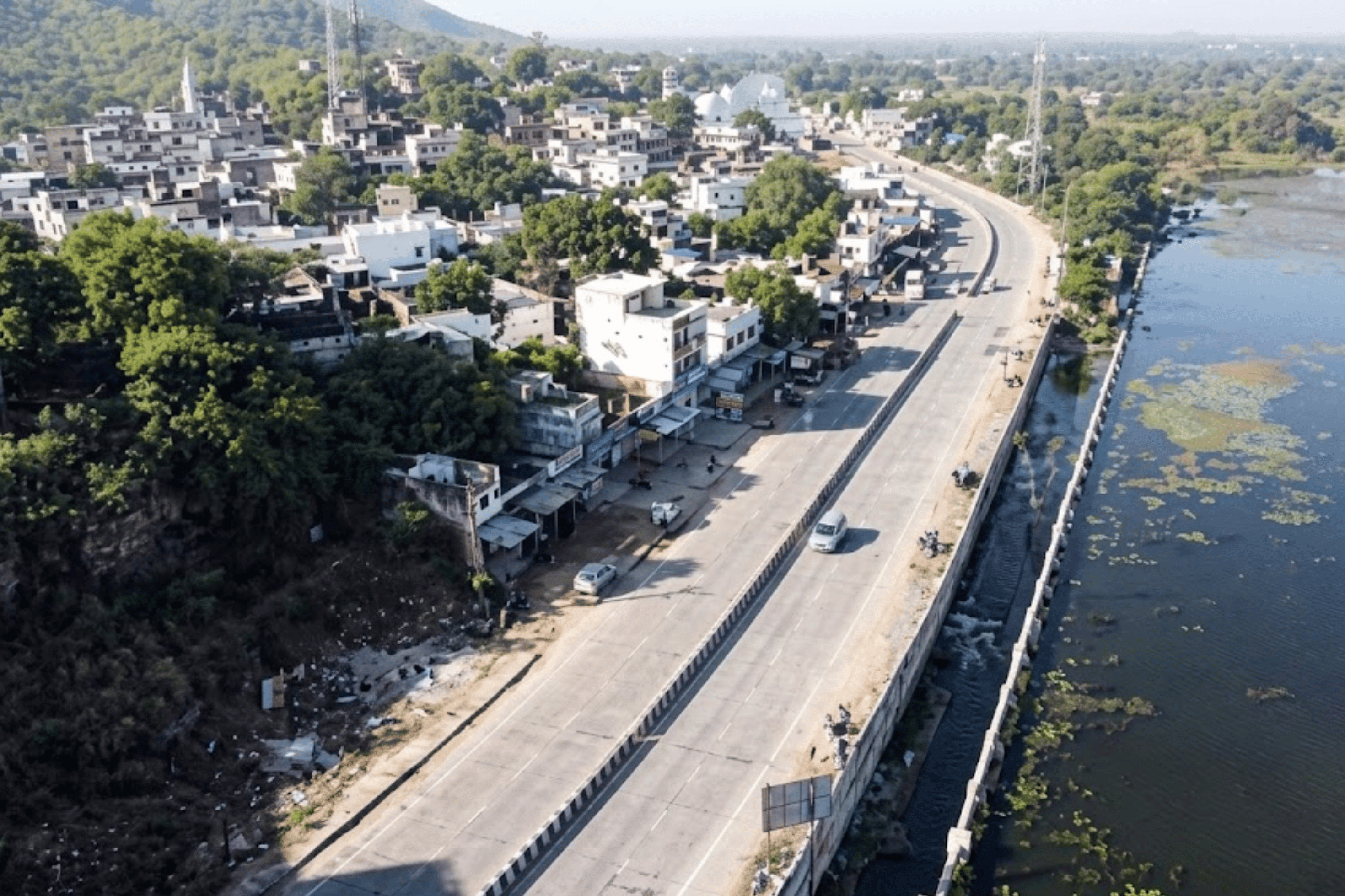
Western Australia's regional road network is among the most geographically challenging in the world. Roads like Twitchin Road in Yannarie and the 6751 and 6710 corridors of the Gascoyne-Murchison region serve agricultural operations, mining logistics, and dispersed communities across landscapes where the nearest maintenance depot may be hundreds of kilometres away. When a road fails in remote WA, the consequences — vehicle damage, supply chain disruption, emergency access loss — are compounded by distance and by the absence of the automated road asset management system that urban networks take for granted.
State and local government road asset managers in these regions have historically relied on infrequent manual inspections — often just once or twice a year — conducted by engineers who cover vast distances with limited time per road. The result is a condition picture that is always months out of date, always subjective, and never granular enough to support evidence-based maintenance programming. Defects are noted in general terms; precise locations are not recorded; severity gradations are not standardised. There is no automated pavement distress detection — only the memory of the last engineer who drove that road.
The survey requirement was clear: cover 74 roads across the region, generate the first-ever objective condition baseline, and produce structured output with the precision, auditability, and repeatability that modern road asset governance requires — at a cost and pace that remote regional operations can sustain.
Remote WA road networks cover enormous distances with minimal maintenance resources. Manual inspection teams cannot achieve the survey frequency, geographic coverage, or data consistency that effective road asset management demands. The Twitchin Rd and 6751/6710 corridors exemplify this challenge — critical regional roads with no objective condition history.
Without a consistent rating methodology, road condition assessments varied between inspectors, surveys, and years. A road described as 'deteriorating' by one engineer and 'fair' by another creates no usable baseline. Asset managers could not compare corridors, prioritise interventions, or build a defensible maintenance budget for state funding submissions.
Traditional field inspection reports identified defects by general description — 'approximately 200m from the intersection.' In remote settings where roads have minimal landmarks, this level of imprecision means contractors routinely work in the wrong location. GPS-referenced defect records are not a convenience; in remote WA, they are operationally essential.
State and federal road funding for remote regions requires evidence-based condition assessments to justify capital allocations. Without standard-rated data, asset managers were presenting subjective reports to funding bodies — limiting their ability to secure the investment that genuinely deteriorated corridors required.
“In remote Australia, a road that fails quietly — through progressive ravelling, rutting, or surface breakdown — may not be reported until it causes a vehicle incident or cuts off community access. By then, the cost of restoration is a multiple of what early intervention would have required.”
RoadVision AI deployed its AI pavement inspection platform across 74 roads in Western Australia's Gascoyne-Murchison region on 9 July 2025 — conducting smartphone-based mobile data collection across corridors ranging from short connector routes to 3.97 KM state-linked arterials. The deployment included Twitchin Road in Yannarie (WA 6710), and the 6751 and 6710 corridor series, with every road processed through the same AI road condition analysis pipeline to ensure consistent, comparable outputs regardless of surface type or remoteness.
Survey teams deployed the RoadVision AI smartphone application across each road in the designated WA network on a single-day mobilisation — 9 July 2025. Vehicles drove at normal speed capturing continuous visual data and GPS tracks. No specialist vehicles, support crews, or lane management infrastructure was required, making the deployment viable in remote locations without the logistics burden that traditional survey methods incur.

All captured footage was processed through RoadVision AI's computer vision engine, automatically detecting and classifying pavement defects across multiple categories at three severity levels. The AI system delivered condition intelligence for all 74 roads within hours of data upload — producing results that would have taken weeks using manual inspection methods across the same geographic area.
Every road was divided into 10-metre analysis segments anchored with precise GPS coordinates (latitude and longitude) extracted from the survey vehicle's real-time GPS track. For Twitchin Road in Talandji, this produced 14+ documented segments from 0–140m with coordinates accurate to six decimal places — enabling contractors to navigate to the exact repair location without ambiguity.
Each surveyed road received an standard-aligned Road Rating computed from its AI-detected defect profile. The 9 July 2025 survey produced ratings spanning the full condition range: 88 (Good) for the best-performing 6751 corridor, 59 and 47 (Fair) for mid-range roads, and 18 (Poor) for the most deteriorated 6710 corridor — giving asset managers a condition-ranked network register for the first time.
All survey outputs were integrated into the RoadVision AI live platform — providing a searchable Road List with real-time condition ratings, one-click report access, full PDF and Excel download, and a GIS map view for spatial planning. The 74-road register (across 8 pages) gives WA asset managers instant access to every corridor's condition status from any device, at any location.
The two screenshots below show the RoadVision AI platform as deployed for the WA regional network — from the district-wide road register to the GPS-segmented chainage analysis of individual corridors. This is the digital safety audit platform interface that road asset managers, local government engineers, and state funding bodies access in real time.

The Road List is the network command view — 74 roads, all rated, all accessible with a single click. The colour-coded condition flags make the network's risk profile immediately legible: the 6710 corridor's Poor rating (18) is flagged in red, the two 6751 variants and Twitchin Road sit in amber Fair, and the best-performing 6751 corridor displays in green at 88 (Good). This is an AI based pavement condition monitoring system at operational scale — a live, always-current register that replaces the static field report that arrives weeks after the inspection.
The rating spread — from 18 (Poor) to 88 (Good) across just four roads on page 1 — confirms what remote WA road managers have long suspected: network condition is highly variable, and without objective data the worst-performing corridors are just as likely to receive maintenance budgets as the best. Pavement analysis software removes that ambiguity and makes prioritisation a data operation, not a political one

The Road Analysis table is where automated pavement distress detection translates into contractor-ready field intelligence. For Twitchin Road in Talandji, every 10-metre segment from 0m to 140m+ is listed with its precise start and end GPS coordinates — down to six decimal places. The consistent Poor rating across all 14 documented segments confirms that this is not a localised problem but a full-corridor failure requiring structural intervention, not spot repairs.
The coordinate precision of the chainage table changes what a work order means in remote WA. A contractor briefed with segment 8's coordinates (-22.126689, 115.023112) can navigate to that exact 10-metre section using a smartphone GPS — no landmark references, no margin for error. In a remote region where the wrong location can mean wasted days of travel and labour, this level of precision is not incidental. It is the core value proposition of the road asset management system.
The WA regional deployment produced the most granular road condition dataset these corridors had ever generated. The findings confirmed a network in mixed condition — from a well-maintained 6751 corridor achieving Good at 88, to a critically deteriorated 6710 corridor at 18 (Poor) — with the full condition spectrum mapped, GPS-anchored, and ready for maintenance programming. This is what AI road condition analysis at network scale actually looks like.

“A 70-point rating spread across a single page of the road register tells you everything about the risk of uniform maintenance budgeting. The road rated 18 and the road rated 88 should not receive the same maintenance allocation — and now, for the first time, there is data to make that argument.”
RoadVision AI's AI based pavement condition monitoring system delivers five structured outputs for WA's regional road asset managers — each serving a distinct user, decision type, and governance layer. Together they constitute a complete digital safety audit platform for the regional network, not a single inspection report.
The operational command view for road asset managers and local government engineers
The structured defect and location data that makes remote contractor deployment accurate

The evidence-based condition documentation that state and federal funding bodies require
The analytical layer that converts 74 individual road ratings into a regional maintenance strategy
The permanent visual record that makes condition findings irrefutable

The WA regional deployment demonstrates what smart city road safety solution technology — originally developed for urban and highway contexts — delivers when adapted for remote regional infrastructure. The outcomes extend beyond the 74 roads surveyed; they represent a new capability for evidence-based road governance in one of Australia's most geographically challenging operating environments.
Ratings replace subjective condition narratives in state and federal funding submissions. A corridor rated 18 (Poor) supported by GPS-tagged, AI-generated evidence is a fundable maintenance case. The same road described as 'deteriorating' in a field report is not. WA road asset managers now have the evidence base that funding bodies require.
In remote WA, sending a contractor to the wrong location wastes a day of travel and labour. The 10-metre GPS chainage register gives contractors exact coordinates for every repair segment — eliminating location ambiguity and enabling accurate remote deployment for the first time.
Pre-survey baselines and post-repair re-surveys create an objective performance measurement that contractors cannot dispute. A Poor-rated corridor must show measurable improvement after structural intervention. The data trail is permanent, GPS-anchored, and available for audit at any time.
When experienced regional engineers retire or transfer, their knowledge of individual road conditions leaves with them. The RoadVision platform retains the complete condition history of every road — every rating, every defect record, every survey date — accessible to whoever manages the network next.
The two Fair-rated corridors (47 and 59) are still within the preventive treatment window. Without condition data, they would likely be deferred until they join the Poor category. With the baseline established, asset managers can programme preventive treatment now at a fraction of future reconstruction cost.
The WA deployment demonstrates that AI pavement inspection is as deployable in remote regional Australia as it is in Indian cities or Gulf highway networks. The methodology, platform, and output format are consistent regardless of geography — making national-scale remote road asset management a practical ambition, not a theoretical one.
“The roads of remote Western Australia don't fail because of a lack of maintenance funding. They fail because the condition data needed to direct that funding to the right places, at the right time, has never existed. That changes with AI.”
Yes. The RoadVision AI computer vision engine is trained across a wide range of road surface types including sealed rural roads, unsealed gravel, and partially deteriorated mixed surfaces. The platform's data collection methodology — smartphone-based continuous video capture at normal driving speed — operates in any road condition that a standard passenger vehicle can traverse. For Twitchin Road and the 6710/6751 corridors in WA's Gascoyne-Murchison region, the system delivered 10-metre GPS-segmented condition ratings without specialist equipment or surface-specific configuration. Remote location, dust conditions, and low-traffic roads do not affect the AI detection capability.
The RoadVision AI output is specifically structured for regulatory and funding body submissions. Every road receives an standard-aligned rating (numeric score plus condition category) computed from AI-detected defect data — not subjective engineer estimation. For WA regional roads, this means asset managers can present funding bodies with a GPS-tagged, standards-referenced condition database rather than a field observation report. A corridor rated 18 (Poor) with chainage-level evidence is a materially stronger case for emergency maintenance funding than a narrative description of deterioration. The report outputs (PDF and Excel) are formatted for direct inclusion in Main Roads submissions and DROC funding applications.
For remote WA operations, GPS precision at chainage level changes the economics of contractor deployment. A contractor mobilised from Perth or a regional depot to Twitchin Road in Talandji faces significant travel cost. If that contractor works on the wrong 100-metre section because the work order said '200 metres from the intersection' rather than providing GPS coordinates, the entire mobilisation is wasted. RoadVision AI's chainage table provides start and end coordinates for every 10-metre segment — accurate to six decimal places. The contractor's smartphone navigates to the exact repair location. Post-repair re-survey verifies that work was performed at the correct chainage. This closes the accountability loop that remote WA maintenance operations have historically been unable to close.
For remote WA roads subject to seasonal variation, the recommended survey cadence is typically twice annually — once before and once after the wet season (or summer heat period, depending on the region) which accelerates surface deterioration. For the 74-road WA network, the initial 9 July 2025 baseline establishes the reference point. Subsequent surveys load automatically against the same road records, enabling deterioration rate calculation, maintenance effectiveness measurement, and predictive maintenance scheduling. Roads that deteriorate significantly between surveys can be programmed for earlier intervention; roads that hold condition can be safely deferred. The platform becomes more valuable with every successive survey cycle as the temporal dataset grows.
Yes. RoadVision AI produces output in Excel and PDF formats that are compatible with all major local government asset management platforms in use across WA, including technology stacks used by regional shires and Main Roads WA. The GPS coordinate data in the chainage register is formatted for direct import into GIS tools including ArcGIS, QGIS, and Google Earth. Road ratings can be mapped against existing asset registers using road names and GPS references. For councils already using road asset management systems, RoadVision AI's output is additive — it provides the condition intelligence that existing systems require as inputs but cannot generate themselves.
RoadVision AI's smartphone-based data collection methodology eliminates the specialist vehicle and equipment costs that traditional pavement survey methods incur. For remote WA deployments, the primary logistics cost is the survey vehicle mobilisation to the region — which is the same cost incurred for any field inspection. The AI processing, platform access, and five-deliverable output are provided at a per-kilometre rate that is significantly lower than specialist pavement survey alternatives. For councils managing large regional road networks, RoadVision AI offers both one-time survey engagements and ongoing monitoring subscriptions that amortise the cost across annual survey cycles. Contact us at roadvision.ai/book-demo for a proposal based on your network size and survey cadence requirements.
Every remote road network in Australia has corridors that are failing without evidence. Now there is a way to find them.
RoadVision AI delivers the complete AI pavement inspection system — from smartphone-based data collection to live regional road register, GPS-anchored chainage analysis, standard-rated condition reports, and funding-submission-ready outputs. Contact us to design a network survey for your WA roads.

The Autonomous Road Engineer
AI that is transforming road infrastructure, from reactive to predictive.