Before this deployment, Riyadh managed its road network the way most Gulf infrastructure authorities do — through visual inspections, complaint-driven responses, and survey cycles that produced inconsistent, non-comparable data that could not support AI infrastructure intelligence systems for billion-dirham capital decisions.
Without a consistent PCI score across the network, there is no way to track whether corridors are improving or deteriorating — or to compare one road against another for budget prioritisation at scale.
Manual inspection depends on field teams who classify defects differently on different days. At scale, this prevents adoption of machine vision for pavement analysis and leads to unreliable datasets.
Aggregate condition scores mask localised deterioration pockets hiding inside healthy averages. High-severity micro-zones go undetected until they escalate into structural failure — and expensive emergency rehabilitation.
Without a pre-repair condition record, contractors can deliver minimum visible compliance. There is no objective way to verify whether resurfacing work met quality standards or whether the treatment held over time without AI-based infrastructure audit systems.
This was not an inspection brief. It was a digital transformation brief — converting 100 kilometres of road surface into a structured, queryable asset record that could drive financial decisions, not just engineering reports.

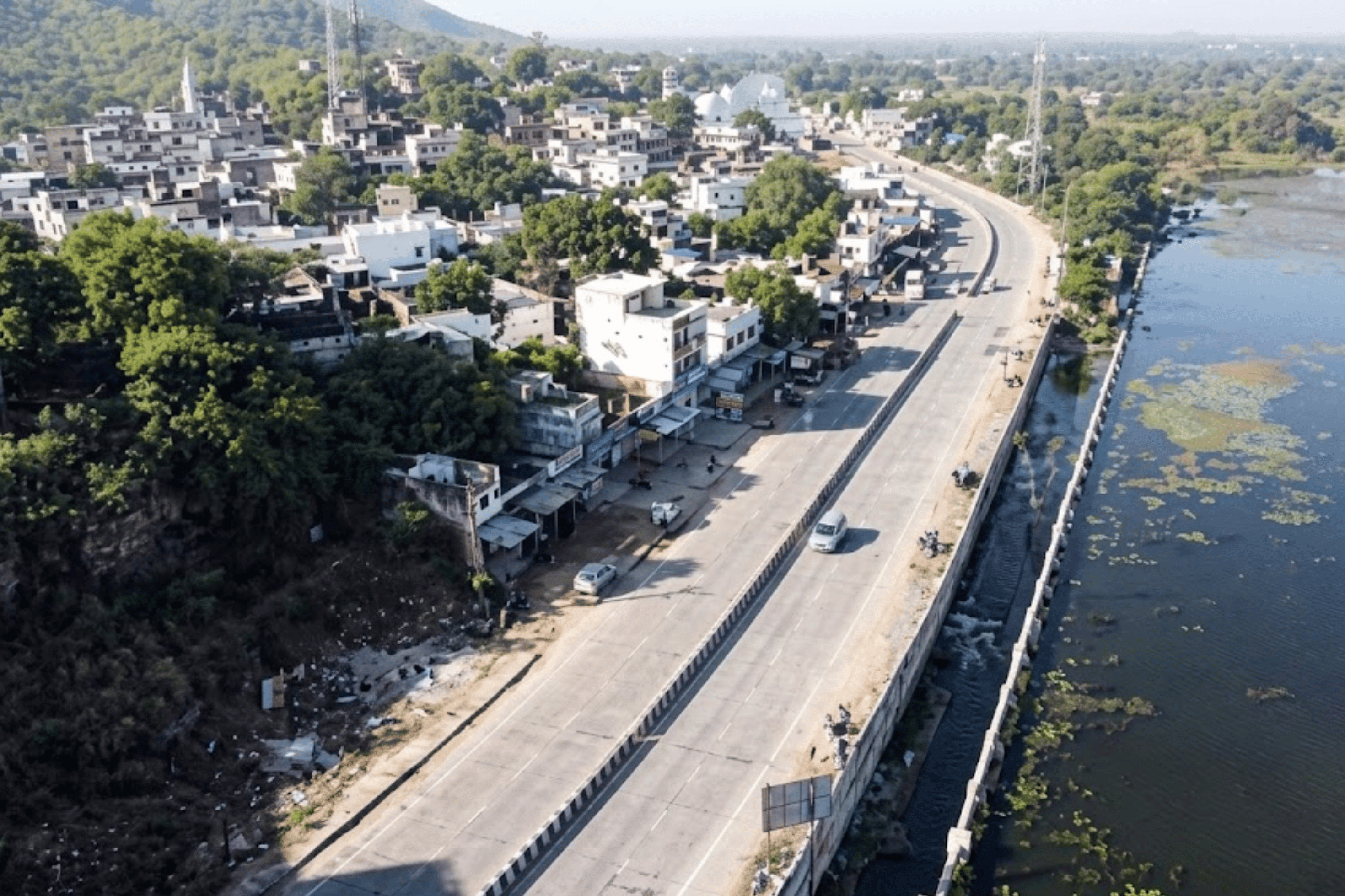
RoadVision AI deployed mobile-equipped vehicles across Riyadh's 100-kilometre network. No lane closures, no specialist equipment, no disruption to the city's traffic. The AI does the rest.
Mobile devices mounted on standard survey vehicles, driven at normal traffic speed across every corridor — LHS, RHS carriageway, and service roads. Every video frame tagged with precise GPS coordinates and timestamp. Zero traffic disruption, zero lane closures, zero specialist mobilisation required — enabling location-aware infrastructure intelligence.
All footage uploaded securely to the RoadVision AI cloud. The deep learning engine — trained on multi-geography road data — analyses every frame automatically, classifying distress types including cracking, rutting, potholes, surface deformation, drainage anomalies, and roadside assets — forming a base for predictive infrastructure maintenance AI.
Each detected defect is GPS-pinned to its exact 10-metre chainage segment. The AI computes a Pavement Condition Index score per segment — from 0 (complete failure) to 100 (perfect) — based on defect type, severity, and extent. Every segment gets a defensible, auditable score. Every corridor gets a comparable record.
Results are published to a live structured platform and compiled into a formal chainage-level report — both ready within the same session as processing. Not a PDF to be manually re-entered, but a structured dataset integrated directly into asset management and capital planning workflows.
Every surveyed corridor gets a permanent, structured record in the platform — an Asset Register with a standardised PCI score that forms the backbone of evidence-based maintenance planning and capital allocation.
Each corridor is assigned a persistent Asset ID in the system. All future surveys automatically map to the same ID — creating a cumulative historical record that survives personnel changes and procurement cycles.
● GPS start and end coordinates recorded per segment
● Road classification, length, and jurisdiction authority
● Persistent ID carried across all future survey cycles
An automated PCI score from 0–100 computed per corridor and per 10-metre segment. Removes subjectivity and gives every road a defensible, comparable rating — directly usable for capital planning decisions.
● Score per corridor and per 10m chainage segment
● Classified as Good / Fair / Poor / Critical
● AI-computed — fully reproducible across survey cycles
Every defect has a GPS-tagged photograph pulled from the survey footage — accessible in the asset report and linked to its exact location on the GIS map. Downloadable in PDF and Excel formats.
● Photo per defect with exact GPS coordinate
● Severity-rated and defect-type classified
● PDF download and structured Excel datasheet
Once a second survey is conducted after repairs, the platform automatically compares PCI scores across survey cycles — showing exactly how each corridor has changed and verifying whether contractor work met standards before payment certification.

Every defect is plotted on a live interactive map. Road segments are colour-coded by condition severity — giving planners and authority officials an instant visual picture of where to focus, without reading a single spreadsheet.

Tap any defect marker to instantly pull up the survey photo from that exact GPS location — with defect type, severity, chainage, and PCI impact score.
Road segments rendered in red (critical), amber (fair), and green (good). Full network health is visible in seconds — no spreadsheet required.
Drill down to see only cracking, only drainage issues, only high-severity defects — or only what changed between two survey periods. Fully filterable in real time.
Switch to heat map view to identify corridors where defects cluster — distinguishing stretches needing structural intervention from those needing routine maintenance only.
Planners, engineers, and authority officials access the same live data simultaneously — one source of truth, from any device, at any time.
From the exact GPS location of a single cracking event to the health score of the entire Riyadh network — structured intelligence at four levels, each designed for a different decision-maker.
Individual defects logged with GPS coordinates, photograph, defect type, severity rating, and measurement. Used for generating specific contractor work orders and field repair instructions with pinpoint accuracy.
> 35+ Parameter types
> 3 Severity levels
Every corridor is divided into 10-metre segments, each with its own PCI score and defect breakdown. Identifies exactly which portion of a road is failing — so repair is targeted precisely, not applied to the full length.
> 10 m Min resolution
> 100% AI-classified
Comprehensive report per corridor — overall PCI score, total defect count by type and severity, photo documentation, remedial recommendations, and historical comparison against previous survey cycles. PDF
> Download Excel
> Datasheet
The network dashboard shows health of the entire system at once — percentage of corridors in good, fair, or critical condition, how aggregate PCI has shifted between surveys, and where to concentrate the maintenance budget for maximum impact.
> 68% Good corridors
> 8% Critical
Conduct a second survey after repairs — or on a scheduled monitoring cadence — and the platform automatically generates a change detection report showing exactly what improved, what deteriorated, and by how much.

The data alone changes how decisions are made — within the same budget, the same team, the same city.
PCI scores at 10-metre resolution are an objective basis for maintenance budget requests — far more persuasive than field observations when presenting to authority leadership or finance departments.
Engineers generate repair work orders directly from the defect list — with GPS coordinates, defect types, severity, and priority ranking already computed by the AI. No guesswork, no manual preparation.
Pre- and post-repair surveys make contractor accountability automatic. A corridor that does not improve measurably cannot be signed off — the timestamped data trail is permanent and irrefutable.
The Asset ID system means every survey builds on the last. When personnel change, the full history of every corridor — every PCI score, every repair, every deterioration event — remains in the platform.
As the temporal database accumulates, the platform identifies deterioration curves — flagging corridors heading toward failure before they fail using predictive infrastructure maintenance AI.
Riyadh's deployment demonstrates a model that scales to any Gulf infrastructure authority. The methodology, platform, and outputs are consistent regardless of network size — what worked for 100 KM works for 1,000.
Field data collection for a 100 KM network is completed using standard vehicles driven at normal traffic speed — no lane closures or specialist mobilisation required. AI processing of the complete footage runs in the same session after upload. A full structured dataset and formal report is ready within the same operational period — not weeks later.
The Pavement Condition Index is a standardised 0–100 rating of road surface condition. RoadVision AI calculates it automatically per 10-metre chainage segment. 10-metre resolution is critical because corridor-level PCI scores hide localised deterioration pockets inside healthy averages — those hidden pockets represent precisely the early-intervention opportunities that prevent escalation into expensive structural rehabilitation.
Yes — this is one of the highest-value applications. By conducting pre- and post-repair surveys, departments get a timestamped, GPS-verified baseline before any intervention and an independent condition measurement after. This creates a structural accountability layer that cannot be disputed, enabling objective quality-based payment certification for the first time.
RoadVision AI detects 35+ parameters across five categories: pavement defects (cracking, potholes, rutting, surface deformation, edge failures), kerb and median conditions, drainage structure health, road safety features (signage, markings, crash barriers, delineators), and roadside assets (encroachments, hoardings, vegetation). All parameters are captured in a single survey pass with no additional equipment.
Every corridor surveyed is assigned a persistent unique Asset ID in the platform. All future surveys automatically map to the same IDs, creating a cumulative temporal database. This enables AI-based deterioration forecasting, maintenance effectiveness measurement through before/after PCI comparisons, and budget optimisation based on predicted condition trajectories rather than complaint patterns or field memory.
The output includes: (1) a video library with raw and AI-annotated footage for every corridor, (2) an Asset Register with PCI scores per corridor and per 10m chainage segment, (3) a live GIS dashboard with colour-coded condition map and filterable defect markers, (4) structured analytics at defect, chainage, corridor, and network levels, and (5) before/after comparison reports across survey cycles. All outputs available in PDF and Excel formats in addition to the live platform.
From survey design to live structured platform — RoadVision AI delivers the full system, not just a report.

The Autonomous Road Engineer
AI that is transforming road infrastructure, from reactive to predictive.
%20(1).png)