Logistics companies, ride-hailing platforms, mobility service providers, urban planning teams, road authorities, and smart city solution builders worldwide build on Google Maps Platform as the geospatial foundation of their operations. It provides the mapping, routing, geocoding, and Places intelligence that powers location-aware applications across virtually every industry vertical. For organisations that move people, goods, or maintenance crews across road networks, Google Maps Platform is already central to how they understand and navigate the built environment.
But one capability is conspicuously absent from the platform: granular, current, ground-truth road condition intelligence the pavement quality, surface defect, and road asset inventory data that determines not just where roads go, but what state they are actually in.
This guide is written for product managers, GIS engineers, urban mobility developers, and road operations teams who are already building on Google Maps Platform and are evaluating how AI-powered road condition data enriches their maps, routes, and location intelligence without rebuilding their geospatial stack.
Before covering where AI road condition analysis data fits, it is worth being precise about what Google Maps Platform actually delivers because this determines exactly where a ground-truth condition layer connects and adds value.
Google Maps Platform is a suite of geospatial APIs and SDKs that gives developers, organisations, and enterprises access to Google’s global mapping, routing, and location data infrastructure. It is not a single product but a family of capabilities Maps, Routes, Places, and Environment that together enable location-aware application development at global scale. For road network applications specifically, Google Maps Platform provides the spatial framework: where roads are, how they connect, what they are named, and how to navigate between points on them.
The Maps JavaScript API, Maps SDK for Android and iOS, and Static Maps API provide the interactive and static map rendering that forms the visual layer of location-aware applications. Developers overlay custom data layers, markers, polygons, and heatmaps on Google’s base map enabling road condition intelligence, maintenance zone boundaries, defect locations, and asset inventory points to be visualised directly on the map surface that users already navigate.
The Routes API and Roads API provide route calculation, turn-by-turn navigation, distance matrix computation, and snap-to-road functionality. For road maintenance applications, these capabilities enable condition-aware routing: directing maintenance crews to defect locations via the most efficient path, routing heavy vehicles around roads with weight or condition restrictions, or optimising inspection vehicle routes to maximise network coverage per survey pass. When road condition data is available as a queryable layer, routing decisions can be weighted against actual pavement quality rather than distance and travel time alone.
The Places API provides access to Google’s database of over 250 million points of interest, business locations, address geocoding, and place attribute data. For road condition applications, Places data provides the contextual layer around road assets: identifying the density of businesses, schools, hospitals, and civic facilities adjacent to road segments with poor condition enabling prioritisation of maintenance investment based on community impact as well as raw condition score.
Google Street View provides 360-degree imagery of road corridors captured by Google’s own survey vehicles. Street View imagery is used for remote desktop inspection, historical condition comparison, and visual context for location-referenced data. However, Street View imagery is updated infrequently typically every one to three years in urban areas, less frequently in rural and secondary road networks and is not designed to support systematic pavement condition assessment, defect detection at the required resolution, or structured asset condition grading.
For organisations building data-intensive location applications, Google Cloud and BigQuery with geospatial extensions provide the infrastructure to store, query, and analyse large geo-referenced datasets at scale. Road condition datasets covering thousands of kilometres of network, with per-segment condition indices and asset detection records, are exactly the kind of geo-referenced structured data that BigQuery’s geospatial functions are designed to handle. The Google Cloud ecosystem provides the data persistence, analytics, and API layer that connects AI-generated road condition intelligence to the Maps Platform visualisation and routing layer.
Across these product families, Google Maps Platform functions as a developer ecosystem rather than a closed application. Organisations build on top of it, extending the base mapping and routing capabilities with their own data layers, business logic, and user interfaces. This openness is exactly what makes AI road condition data a natural fit: condition intelligence is a custom data layer that enriches the Google Maps Platform foundation without requiring any modification to the underlying platform.
Google Maps Platform knows an extraordinary amount about where roads are, how they connect, and how to navigate between points on them. What it does not know and is not designed to know is what condition those roads are currently in.
This gap matters differently depending on the application, but it is consistently present across the most significant road network use cases:
Street View partially addresses the visual gap but its update frequency, resolution limitations, and lack of structured condition classification make it unsuitable as a systematic road condition data source for operational applications.
This is not a gap in Google Maps Platform’s design intent. It is a consequence of the distinction between network topology data what Google Maps knows and ground-truth physical condition data what AI road surveys provide. They are complementary, not competitive.
AI-based computer vision for road surveys generates the ground-truth condition intelligence that Google Maps Platform cannot produce on its own. The approach is operationally straightforward: a vehicle-mounted dashcam captures geo-tagged, time-stamped video of the road network as the vehicle drives at normal operating speeds. That footage is processed through AI models that detect and classify road conditions and assets automatically, returning structured, geo-referenced results that integrate directly into Google Maps Platform as a custom data layer.
No specialist survey vehicle. No LiDAR rig. No dedicated inspection crew. Any fleet vehicle maintenance trucks, delivery vehicles, ride-hailing cars, bus fleet, inspection vans already operating across the road network becomes a continuous survey platform. For organisations that already have vehicles on the road at scale, this is a significant operational leverage point: the survey network is the operating fleet.
RoadVision AI’s models are trained on over 100 million road images from networks across South Asia, the Middle East, Southeast Asia, Europe, and Africa, covering diverse pavement types, climate conditions, road classifications, and urban and rural environments. This training breadth is directly relevant to Google Maps Platform users, whose applications frequently span multiple countries and road network types. A model trained primarily on North American highway footage will underperform on the mixed-surface, variable-quality networks common in the markets where road condition data has the most operational urgency.
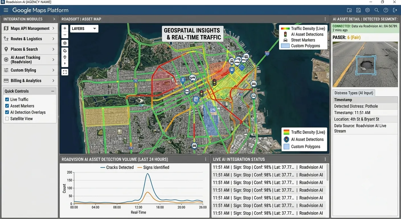
A single dashcam survey pass, processed through the RoadVision AI pipeline, returns geo-referenced intelligence across the following categories each directly mappable as a Google Maps Platform custom layer:
Detection and classification of surface distress including potholes, longitudinal cracking, transverse cracking, alligator (fatigue) cracking, rutting, edge deterioration, patching quality, and surface ravelling. Each finding is severity-scored (Low / Medium / High / Critical) and contributes to a per-segment Pavement Condition Index (PCI) aligned to ASTM D6433 and IRC:116. An IRI-equivalent roughness value is also returned per 100-metre segment. Every detection record carries GPS coordinates and timestamp, making it natively compatible with Google Maps Platform overlay rendering.
Automated road detection and classification of 80+ road asset types: regulatory signage, warning signs, informational signs, road markings (centreline, edge line, stop bars, pedestrian crossings, chevrons), kerb and edge conditions, guard rails and safety barriers, crash attenuators, drainage structures, culverts, lighting columns, and ITS infrastructure. Every asset detection includes GPS coordinates, asset type, condition grade, and a photographic evidence frame renderable as a Google Maps marker layer with custom icons and info windows.
Detection of safety deficiencies including faded or absent pavement markings, damaged safety barriers, vegetation encroachment onto carriageway clearances, sight-line obstructions, and right-of-way intrusions. Each safety finding is geo-tagged and severity-scored, enabling safety risk visualisation as a heatmap or marker layer on Google Maps.
Identification of roadside vegetation analysis that encroaches on carriageway clearance or affects driver visibility, and detection of structures or objects within the right-of-way boundary.
Every detection record includes: defect or asset type, severity or condition grade, confidence score, GPS coordinates, route chainage, timestamp, and a geo-tagged photographic evidence frame. Output formats include GeoJSON, which is natively supported by the Google Maps JavaScript API for custom layer rendering without any format conversion.
Google Maps Platform’s open API architecture is designed for exactly this kind of data layer integration. AI-generated road condition data connects to the platform through several well-supported integration patterns, depending on the application type and use case:
Road condition data delivered as GeoJSON loads directly into Google Maps via the Data Layer feature of the Maps JavaScript API. Pavement condition segments render as colour-coded polylines on the map surface green for good condition, amber for fair, red for poor, dark red for critical creating a condition heatmap that updates as new survey data is processed. Defect point locations render as custom markers. Asset inventory points render as icon-coded markers with info windows containing condition grade, detection date, and photographic evidence. The entire condition layer is added to a standard Google Map with a few lines of JavaScript no custom mapping infrastructure required.
Road condition data stored as a queryable geospatial dataset in Google Cloud / BigQuery can be used to modify routing decisions made via the Routes API. Applications can query the condition dataset to identify road segments below a defined quality threshold, exclude them from routing options for specific vehicle types, or apply a cost weighting to routes passing through poor-condition sections. For maintenance fleet dispatch, this enables crews to be routed to defect locations via the most direct passable path. For heavy goods vehicle routing, it enables the exclusion of road segments where pavement condition is unsuitable for high axle loads.
For applications that use the Street View Static API or Embed API to display roadway imagery, AI survey evidence photos provide a complementary, current-condition view. Where Street View shows the road as it was at the time of Google’s last survey vehicle pass, AI dashcam evidence frames show the road as it was at the time of the most recent survey run which for a fleet operating daily may mean this week or this month. For desktop inspection workflows and maintenance planning dashboards built on Google Maps, this combination of Google Street View context and AI evidence imagery gives reviewers the most complete visual picture available.
For organisations using Google Cloud and BigQuery as their data infrastructure, AI road condition datasets load directly into BigQuery as geo-referenced tables. BigQuery’s native geospatial functions ST_GEOGPOINT, ST_INTERSECTS, ST_DISTANCE, and related functions enable spatial queries across the condition dataset: which segments are within a maintenance zone boundary, which defects are within 500 metres of a school or hospital, which road sections have deteriorated between the last two survey cycles, what is the total length of network in each condition band. These analytics feed directly into Looker Studio dashboards, Google Maps-embedded reporting tools, and Google Sheets exports.
The Google Maps Platform Datasets API allows organisations to upload large geospatial datasets and render them as custom map layers at scale without the performance limitations of client-side GeoJSON rendering for large datasets. AI road condition data for large network areas city-scale or regional uploads to the Datasets API and renders as a high-performance condition layer on Google Maps, suitable for public-facing infrastructure dashboards, community reporting tools, and executive performance views.
For applications requiring near real-time condition data active maintenance dispatch dashboards, live defect reporting tools, or fleet monitoring platforms. RoadVision AI supports webhook-based delivery of processed survey results. As footage is processed, condition and defect records push to a configured endpoint, from which they load into the Google Maps layer and BigQuery dataset without manual intervention. For fleet operators with vehicles surveying continuously, this enables condition data to flow into the map view on a rolling basis as the fleet operates.
Once integrated, AI road condition data enriches every Google Maps Platform application the organisation already operates: infrastructure dashboards gain a live condition layer, maintenance dispatch tools gain evidence-backed defect locations, routing applications gain condition-weighted path options, and analytics environments gain a queryable condition dataset. Development teams work within the Google Maps Platform environment they already know the AI condition data is an additional data source, not a new platform.
What does not change: The Google Maps Platform APIs. The development environment. The application architecture. The routing logic. The visualisation framework. The Google Cloud data infrastructure.
What changes: The depth and accuracy of the road condition intelligence available as a data layer within that environment.
Maps gain a ground-truth condition dimension. Google Maps shows the road network with extraordinary accuracy and global coverage. AI condition data adds the dimension that Google Maps currently lacks: the physical state of the road surface. A pavement condition analysis heatmap overlay on a Google Map immediately shows road authorities, planners, and operations teams not just where roads are but which ones need attention in the spatial interface they already use daily.
Routing decisions gain a road quality input. Current Google Maps routing optimises for time and distance. With AI condition data available as a queryable layer, routing applications can additionally optimise for road quality avoiding deteriorated segments for passenger comfort, protecting high-value vehicles from rough surfaces, routing maintenance crews directly to the highest-severity defects, or excluding road sections below a defined quality threshold from heavy vehicle routing. The routing API remains unchanged; the condition data becomes an additional input to the routing logic.
Fleet operations gain passive network intelligence. For logistics, delivery, and ride-hailing operators with large vehicle fleets already driving road networks at scale, mounting dashcams on existing fleet vehicles converts every vehicle journey into a condition survey pass. The road network is surveyed continuously as the fleet operates without dedicated survey vehicles, without scheduling overhead, and without additional crew. Google Maps Platform’s fleet tracking and routing tools continue to function as before; the AI layer generates condition intelligence as a by-product of normal fleet operations.
Urban planning and smart city applications gain current condition data. Digital twin platforms, urban mobility dashboards, and infrastructure planning tools built on Google Maps need current road condition as a foundational data layer. AI road survey data provides this at the segment level, updated as frequently as the survey fleet operates, in formats that integrate directly into the Google Maps-based spatial viewer. Planning decisions, maintenance budget allocations, and community reporting tools are grounded in current field conditions rather than stale survey data.
Risk and insurance applications gain segment-level condition intelligence. Location-based risk assessment applications built on Google Maps Platform can incorporate AI-derived pavement condition data as a risk signal: segment PCI, pothole density, marking visibility, and barrier condition are all inputs to road risk scoring. The Maps Platform provides the spatial framework; AI condition data provides the physical risk attribute layer.
The evaluation path is designed to be low-friction for Google Maps Platform developers:
For organisations building on Google Maps Platform, the question is not whether road condition data would make their applications more useful — it clearly would. The question is whether that data can be acquired at the required coverage, frequency, and format to integrate cleanly into a Google Maps-based product without adding significant infrastructure complexity. That is what this integration is designed to deliver.
Any GPS-enabled dashcam producing standard MP4 or MOV video at 1080p or above. No proprietary hardware, no calibration rig, no vehicle modifications beyond mounting the camera. Any vehicle in an existing fleet delivery van, maintenance truck, ride-hailing car, inspection vehicle can serve as a survey platform.
No. The models are pre-trained and deployed across diverse road network types globally. There is no model training cost, no annotation project, and no configuration work required. If your application covers specific road types, surface classifications, or asset categories not covered by standard outputs, these are handled as a configuration on the RoadVision AI side.
AI road condition data is delivered as GeoJSON the format natively supported by the Google Maps JavaScript API Data Layer. Pavement segments are delivered as GeoJSON LineString features with condition attributes; defect and asset detections are delivered as GeoJSON Point features with type, severity, and evidence photo URL. Loading the condition layer onto a Google Map requires adding a Data Layer and calling loadGeoJson() with the condition data URL — a straightforward integration that most Google Maps developers can implement in under an hour.
Google Street View provides valuable visual context but is designed for navigation, not systematic condition assessment. Street View imagery is updated infrequently (typically annually in urban areas, less often elsewhere), lacks structured condition classification, and is not designed for pothole or defect detection at the required resolution. AI dashcam survey data provides structured condition indices, per-defect detection records, severity scores, and asset classifications updated as frequently as the survey fleet operates. The two are complementary: Street View for visual context, AI condition data for structured operational intelligence.
Standard processing turnaround is 24–48 hours from footage submission, depending on survey volume. For organisations with vehicles operating continuously, webhook delivery makes processed condition data available in the Google Maps layer within hours of each survey batch completing. For large-network batch surveys, data is delivered as a single processed dataset ready for bulk upload to the Datasets API or BigQuery.

The Autonomous Road Engineer
AI that is transforming road infrastructure, from reactive to predictive.
.webp)

.webp)