Transport agencies, highway authorities, port operators, airports, and large municipalities worldwide rely on IBM Maximo Application Suite as the enterprise backbone of their infrastructure and asset management operations. It manages work orders, asset registers, preventive maintenance schedules, procurement, labour, and compliance workflows that organisations have built, integrated, and scaled over years. For most large infrastructure operators, it is not going anywhere.
But one question is coming up more frequently across road maintenance and infrastructure operations teams: how do we bring AI road condition data into Maximo without rebuilding the enterprise asset management workflows we already depend on?
This guide is written specifically for road asset managers, infrastructure operations directors, and Maximo system administrators who are already working within the IBM Maximo ecosystem and are evaluating how AI-powered road condition assessment fits into not on top of their existing enterprise setup.
Before covering where AI fits, it is worth being precise about what IBM Maximo actually provides for road asset management because this determines exactly where an AI condition data layer connects.
IBM Maximo Application Suite is an enterprise asset management (EAM) and CMMS platform that manages the full lifecycle of physical assets from procurement and commissioning through to maintenance, inspection, and decommissioning. In a road infrastructure context, Maximo handles the operational layer: who does what, when, with what resources, at what cost, and with what documented outcome. Every road asset, work order, inspection record, and maintenance cost in the organisation flows through Maximo’s structured data model.
Maximo maintains the master asset register for road infrastructure: pavement segments, bridges, signs, markings, drainage structures, lighting, safety barriers, and all associated sub-components. Each asset record carries location, classification, installation date, specification, warranty status, condition grade, and full maintenance history. For large highway operators and municipalities managing tens of thousands of road assets across a network, Maximo’s asset hierarchy and classification framework is the authoritative record of what the organisation owns and operates.
Work orders in Maximo are the primary mechanism for planning, assigning, executing, and documenting all maintenance and inspection activity. Road maintenance crews receive work orders through Maximo, record materials consumed, labour hours, and completion status, and close the record with documented outcomes. Every maintenance intervention - pothole repair, sign replacement, line marking, drainage clearance, barrier repair is traceable through a Maximo work order with full cost attribution and compliance documentation.
Maximo’s preventive maintenance (PM) module automates the generation of work orders based on time intervals, asset age, usage thresholds, or condition triggers. For road infrastructure, this means routine inspections, seasonal maintenance activities, and condition-based intervention triggers can be scheduled and executed systematically rather than reactively reducing the proportion of maintenance that is driven by failure or complaint rather than planned condition management.
Maximo supports structured inspection workflows: inspection templates, condition ratings, defect recording, and photographic evidence attachment, all linked to specific asset records. Field inspectors use Maximo’s mobile interface to conduct and record road inspections in the field, with results feeding directly into the asset’s condition history and triggering work orders for defects above defined thresholds.
Beyond asset and work order management, Maximo handles the full operational support layer: crew scheduling and labour tracking, equipment deployment, materials management and procurement, contractor management and purchase orders, and budget control against maintenance cost centres. For highway operators and municipalities, this makes Maximo the single system of record for both the physical condition of road assets and the cost of maintaining them.
Maximo maintains a complete, time-stamped audit trail of all asset activity inspections conducted, defects found, work orders raised, maintenance completed, costs incurred. This audit trail is what organisations use to demonstrate duty of care compliance in road safety and infrastructure management: evidence that known defects were identified, assessed, and remediated within defined timeframes. For highway authorities with statutory maintenance obligations, this compliance record is as operationally critical as the maintenance work itself.
Maximo integrates with ERP systems (SAP, Oracle), GIS platforms (Esri ArcGIS), financial management systems, HR and scheduling platforms, and field mobility solutions. IBM Maximo Application Suite includes Maximo Mobile for field operations and connects to IBM’s broader AI and analytics ecosystem through IBM Watson and the IBM Cloud Pak for Data platform. Open APIs and integration frameworks allow Maximo to receive data from external systems a capability directly relevant to AI survey integration.
IBM Maximo manages road asset operations with enterprise-grade rigour and auditability. What it does not do is generate condition data.
The condition grades, inspection records, and defect findings in the Maximo asset register are only as current as the last time someone physically inspected the network and entered the results. In practice, for most road operators and highway authorities, that means:
The result: a well-structured, operationally active enterprise asset management system whose condition records may be a year or more out of date, inconsistently measured, and systematically missing the early-stage defects that preventive maintenance programmes are designed to address.
This is not a criticism of IBM Maximo. It is a structural limitation of how road condition data has historically been collected. The platform can only manage what it is told about.
AI-based computer vision for road surveys addresses the condition data generation problem directly. The approach is operationally simple: a vehicle-mounted dashcam captures geo-tagged, time-stamped video of the road network as the vehicle drives at normal operating speeds. That footage is processed through AI models that detect and classify road conditions and assets automatically, returning structured results that load directly into the existing enterprise asset management environment.
No specialist survey vehicle. No dedicated inspection crew. No manual rating forms. No scheduling bottleneck. Any fleet vehicle maintenance trucks, inspection vans, supervisor vehicles already driving the network daily becomes a continuous survey platform.
RoadVision AI’s models are trained on over 100 million road images from networks across South Asia, the Middle East, Southeast Asia, Europe, and Africa, covering diverse pavement types, climate conditions, road classifications, and asset configurations. The breadth of training data is what determines whether a model performs accurately outside a controlled test environment on worn urban roads, industrial estate access roads, airport aprons, port access routes, and the full range of surface types that Maximo-managed infrastructure operators maintain. It is also what removes the need for organisations to train or fine-tune models themselves, which is typically where AI adoption projects stall.
A single dashcam survey pass, processed through the RoadVision AI pipeline, returns intelligence across the following categories:
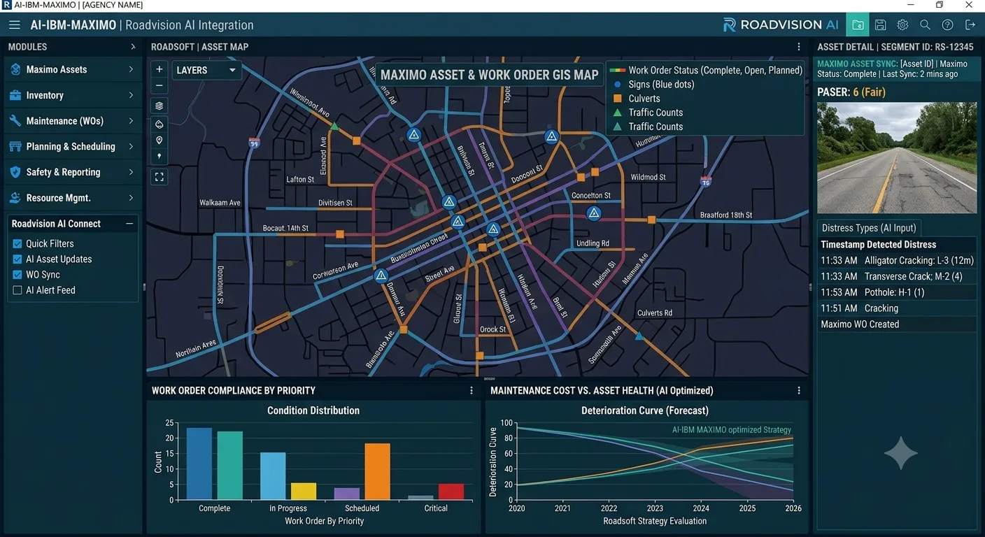
Detection and classification of surface distress including potholes, longitudinal cracking, transverse cracking, alligator (fatigue) cracking, rutting, edge deterioration, patching quality, and surface ravelling. Each finding is severity-scored (Low / Medium / High / Critical) and contributes to a per-segment Pavement Condition Index (PCI) aligned to ASTM D6433 and IRC:116. An IRI-equivalent roughness value is also returned per 100-metre segment. Every detected defect is a candidate for a Maximo work order, with severity score informing priority classification.
Automated detection and classification of 80+ road asset types: regulatory signage, warning signs, informational signs, road markings (centreline, edge line, stop bars, pedestrian crossings, chevrons), kerb and edge conditions, guard rails and safety barriers, crash attenuators, drainage structures, culverts, lighting columns, and ITS infrastructure. Every asset detection includes GPS coordinates, asset type, condition grade, and a photographic evidence frame ready to create new asset records or update existing records in the Maximo asset register.
Detection of safety deficiencies including faded or absent pavement markings, damaged safety barriers, vegetation encroachment onto carriageway clearances, sight-line obstructions, and right-of-way intrusions. Each safety deficiency record provides the documentation needed to demonstrate that the condition was identified, dated, and entered into the maintenance management system directly supporting duty of care compliance in Maximo.
Identification of roadside vegetation growth that encroaches on carriageway clearance or affects driver visibility, and detection of structures or objects within the right-of-way boundary.
Every detection record includes: defect or asset type, severity or condition grade, confidence score, GPS coordinates, route chainage, timestamp, and a geo-tagged photographic evidence frame. The photographic evidence and timestamp are directly attachable to Maximo work order and inspection records, providing the audit trail documentation that compliance workflows require.
IBM Maximo manages road assets and maintenance through structured records assets, locations, work orders, inspection results, and PM schedules with defined attribute schemas and integration interfaces. RoadVision AI outputs are structured to map directly to those schemas, enabling AI-detected road condition data to enter Maximo’s operational workflows without manual re-entry, data transformation, or system administration overhead.
This is the most operationally significant integration point. AI-detected defects above a defined severity threshold are delivered as structured work order creation requests via the Maximo REST API or integration framework. Each request includes: asset ID or location reference, defect type, severity classification, GPS coordinates, detection timestamp, and attached photographic evidence. Maximo creates the work order, assigns it to the correct asset record, attaches the evidence photo, and routes it through the existing priority and assignment workflow without any manual intervention between AI detection and work order appearance in the crew queue.
AI survey results update the condition attributes on existing Maximo asset records: pavement condition index, IRI roughness score, defect type presence, and overall condition grade. Each update is date-stamped and appended to the asset’s condition history, building a continuous, consistently measured condition time-series within Maximo the foundation that condition-triggered PM rules and maintenance planning tools depend on.
For organisations using Maximo’s structured inspection workflow, AI survey results are delivered as completed inspection records with inspection template fields populated, condition ratings assigned, defects documented, and photographic evidence attached. This means AI surveys appear in Maximo as formal inspections, with the same record structure and audit trail as manual field inspections, satisfying compliance and reporting requirements without creating a parallel data track.
Maximo’s PM module generates work orders when condition thresholds are crossed. AI survey data, loaded as condition attributes on asset records, activates these triggers: a pavement segment whose AI-measured PCI drops below a defined threshold automatically generates a PM work order for the appropriate treatment. Condition-based PM scheduling becomes genuinely condition-based driven by current AI-measured asset state rather than by time intervals approximating expected deterioration.
RoadVision AI connects to Maximo through its REST API, Integration Framework (MIF), or IBM App Connect middleware, depending on the agency’s Maximo deployment configuration. For organisations running Maximo Application Suite on IBM Cloud or as a SaaS deployment, webhook-based delivery allows AI road survey results to push into Maximo in near real-time as processing completes. For on-premises or hybrid deployments, scheduled batch delivery via the Integration Framework is available.
AI detection results include GPS coordinates and, where the agency’s Maximo environment is connected to a GIS platform, chainage and spatial references that align to existing location records in the asset register. For organisations running Maximo with Esri ArcGIS integration, AI survey outputs are available in GeoJSON or Shapefile format for simultaneous loading into both the GIS layer and the Maximo asset record keeping spatial and operational records in sync.
Once integrated, AI survey data participates in every downstream Maximo workflow the organisation already runs: condition-based work order prioritisation, PM schedule optimisation, maintenance cost tracking against asset records, duty of care compliance audit trails, contractor performance measurement, and infrastructure budget reporting. Operations teams work in the same Maximo environment they have always used; the difference is that asset condition records are current, comprehensive, and continuously updated.
What does not change: The Maximo platform. The team’s workflows. The asset register structure. The work order process. The PM scheduling framework. The compliance and audit trail. The reporting hierarchy. The enterprise integrations.
What changes: The frequency, coverage, and consistency of the condition data entering those workflows and through them, the operational effectiveness of everything Maximo is designed to do.
Survey frequency increases without a proportional staffing increase. Because any fleet vehicle already driving the road network can capture survey footage, the marginal cost of an additional survey pass is low. A road network inspected on an annual or multi-year cycle can be surveyed monthly, or weekly on high-priority corridors, without additional inspection headcount. Maximo’s condition records are updated continuously rather than refreshed once a year.
Coverage becomes genuinely complete. Traditional inspection programmes prioritise principal roads and known problem areas because manual inspection resources are finite. AI dashcam survey footage covers the full managed network residential streets, secondary access roads, car parks, service roads, and every other paved surface the organisation is responsible for on every survey pass. Maximo asset records that have not been updated for years receive current condition data.
Preventive maintenance becomes genuinely preventive. Maximo’s PM module is designed to schedule maintenance before failure but without current condition data, PM schedules default to time-based approximations. With AI condition data continuously updating road asset and monitoring records, condition-triggered PM rules fire on actual deterioration rather than elapsed time. Early-stage defects hairline cracking, minor drainage blockage, fading markings trigger low-cost preventive work orders before they escalate to more expensive remediation.
Duty of care compliance becomes demonstrably robust. Every AI detection generates a time-stamped, geo-tagged, evidence-backed record in Maximo. The audit trail defect detected, work order raised, maintenance completed is complete, consistent, and defensible. For highway operators with statutory maintenance obligations, this documentation record significantly reduces the liability exposure created by gaps in manual inspection coverage.
Work order queues become data-driven rather than complaint-driven. When AI surveys detect and severity-score defects across the full network, work order prioritisation reflects actual network condition rather than recency of public complaint or proximity to an inspector’s last route. Maintenance resources are deployed where the condition data says they are needed most.
Asset records become a living inventory. Sign condition, marking visibility, drainage status, and barrier integrity are updated with every survey pass. The Maximo asset register reflects the current field state rather than a snapshot from the last inventory campaign keeping maintenance planning, procurement forecasting, and lifecycle cost tracking grounded in reality.
The evaluation path is designed to be low-friction:
For road operators evaluating AI survey tools, the practical question is not whether AI-powered road detection is technically viable it demonstrably is. The question is whether it integrates cleanly into the enterprise asset management environment the team already operates, triggering work orders automatically, updating asset records continuously, and producing the compliance documentation that operational and legal requirements demand. That is what this integration is designed to ensure.
Any GPS-enabled dashcam producing standard MP4 or MOV video at 1080p or above. No proprietary hardware, no calibration rig, no vehicle modifications beyond mounting the camera. Fleet vehicles already operating on the road network require no modifications other than camera installation.
No. The models are pre-trained and deployed. There is no model training cost, no annotation project, and no configuration work required on the organisation’s side. If your road network includes specific asset types, surface classifications, or defect categories that differ from standard outputs, these are handled as a configuration on the RoadVision AI side.
RoadVision AI integrates with Maximo through the Maximo REST API, the Maximo Integration Framework (MIF), or IBM App Connect, depending on your deployment configuration. For Maximo Application Suite (MAS) on IBM Cloud or SaaS, webhook delivery pushes AI results directly into Maximo as processing completes. For on-premises Maximo deployments, scheduled batch delivery via the Integration Framework is available. The RoadVision AI technical team configures the integration to match your specific Maximo version and deployment architecture.
Yes. Defects detected above a configured severity threshold are delivered as work order creation requests via the Maximo API. Each work order request includes asset reference, defect type, severity, location, detection timestamp, and attached photographic evidence. Work orders appear in the crew queue with the same structure and routing as manually created work orders no additional configuration of the downstream workflow is required.
AI-derived condition scores are loaded as asset condition attributes in Maximo, which activates any condition-threshold PM rules already configured for those assets. If your PM schedules are currently time-based due to a lack of current condition data, the RoadVision AI technical team can assist with configuring condition-trigger rules in Maximo to make full use of the updated condition attributes moving PM from time-based approximation to genuine condition-based scheduling.
Yes, directly. Every AI detection generates a time-stamped, geo-tagged, photographic evidence record. When loaded into Maximo as inspection findings, these records form part of the compliance audit trail: evidence that defects were detected on a specific date, at a specific location, at a defined severity level, and that a work order was raised in response. For highway authorities with statutory inspection and response obligations under the UK Highways Act, MUTCD, or equivalent national frameworks this documentation significantly strengthens the defensibility of the compliance record.
Standard processing turnaround is 24–48 hours from footage submission, depending on survey volume. For organisations running regular survey cycles with automated API delivery to Maximo, the pipeline is configured to deliver results on a defined schedule aligned to the organisation’s operational rhythm.

The Autonomous Road Engineer
AI that is transforming road infrastructure, from reactive to predictive.

.webp)
.webp)