Florida's coastline is both a blessing and a burden. While it fuels tourism, trade, and economic vitality, it also exposes the state's road infrastructure to some of the harshest climate threats in the USA. Rising sea levels, powerful hurricanes, saltwater intrusion, and frequent flooding all take a serious toll on coastal highways. These impacts shorten pavement life cycles, increase maintenance costs, and endanger millions of road users.
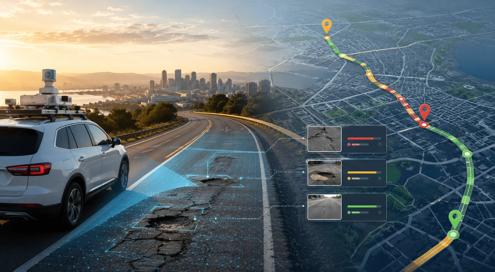
In this high-risk environment, traditional highway inspections often operate like "trying to catch water with a sieve"—too slow, too manual, and too outdated to keep up with rapidly changing conditions. This is why AI-powered road monitoring is becoming an essential part of Florida's climate-resilient infrastructure strategy. By integrating advanced AI highway monitoring Florida solutions through the Pavement Condition Intelligence Agent and Road Safety Audit Agent, the state can safeguard its coastal corridors before minor issues snowball into major failures.

Florida's network—including major corridors such as Interstate 95, Interstate 75, and numerous coastal highways—forms the backbone of freight movement, tourism flow, and emergency evacuation routes. But these critical assets face persistent challenges:
These conditions make early detection absolutely vital. AI-enabled road inspection platforms help agencies spot cracks, potholes, water damage, and structural weaknesses long before they escalate—supporting the development of climate-resilient roads USA.
2.1 Interstate 95 along the East Coast
As the primary north-south artery, I-95 faces multiple climate threats including storm surge impacts in coastal sections and flooding during extreme rainfall events.
2.2 Interstate 75 (Alligator Alley)
Crossing the Everglades, this critical east-west connection is vulnerable to flooding, wildlife impacts, and storm surge from both coasts.
2.3 US 1 (Overseas Highway) to the Florida Keys
This iconic route faces existential threats from sea level rise, storm surge, and hurricane damage, requiring specialized monitoring.
2.4 A1A Coastal Byway
Running along the Atlantic coast, this scenic route is directly exposed to wave action, erosion, and storm impacts.
2.5 Tampa Bay Area Bridges and Causeways
The region's extensive bridge network faces corrosion threats from saltwater and storm surge vulnerability.
While Florida adheres to strict standards under the Florida Department of Transportation (FDOT) and the Federal Highway Administration (FHWA), several universal monitoring principles remain central:
3.1 Real-Time, High-Fidelity Data Collection
Highway conditions must be captured continuously, not sporadically, to reflect rapid environmental changes through the Pavement Condition Intelligence Agent.
3.2 Early Hazard Identification
Minor cracks, ponding, or surface distress should be detected before storms amplify the damage through the Road Safety Audit Agent.
3.3 Predictive Maintenance Strategies
Using data-driven insights to allocate resources efficiently and prevent expensive future failures through the Pavement Condition Intelligence Agent.
3.4 Safety-First Road Assessments
Crash risks, reduced visibility, worn striping, and weakened shoulders must be monitored with precision through the Road Safety Audit Agent.
3.5 Asset-Level Inventory Accuracy
Every guardrail, culvert, signal, and drainage feature should be digitally tracked for compliance and maintenance planning through the Roadside Assets Inventory Agent.
3.6 Traffic Pattern Understanding
Vehicle classifications, volumes, and evacuation route usage from the Traffic Analysis Agent inform both design and emergency planning.
These principles guide the evolution of Florida's highway management—and AI makes them significantly easier to uphold.
4.1 Hurricane Impacts
Hurricanes bring multiple threats simultaneously:
4.2 Sea Level Rise
Gradual but relentless sea level rise causes:
4.3 Saltwater Corrosion
Chloride exposure affects:
4.4 Temperature Extremes
Florida's heat accelerates:
4.5 Intense Rainfall
Short-duration, high-intensity storms cause:
RoadVision AI, one of the most advanced platforms in the global road asset management domain, applies AI, digital twins, and computer vision to deliver highly accurate, scalable insights across Florida's highways through its integrated suite of AI agents. Its best practices include:
5.1 AI-Powered Pavement Condition Monitoring
The Pavement Condition Intelligence Agent identifies:
—far earlier than manual inspections. This helps agencies plan repairs ahead of hurricane season or heavy-rain periods.
5.2 Enhanced Predictive Pavement Life-Cycle Modelling
By simulating:
through the Pavement Condition Intelligence Agent, RoadVision AI supports smarter, cost-efficient maintenance schedules—extending pavement life and optimizing budgets.
5.3 Comprehensive Road Safety Audits
The Road Safety Audit Agent uses computer vision and historical crash data to conduct detailed safety risk assessments that align with FDOT and FHWA design and safety protocols, identifying:
5.4 Automated Road Inventory Inspections
The Roadside Assets Inventory Agent digitally captures:
—reducing on-ground survey time dramatically and ensuring complete asset visibility.
5.5 Intelligent Traffic Surveys
The Traffic Analysis Agent provides AI-based traffic analysis that delivers insights into:
5.6 Pre- and Post-Storm Assessments
The platform enables:
These capabilities transform maintenance from reactive to predictive—much like moving from a "firefighting" approach to a "prevention-first" strategy.
Even with improved planning, Florida faces a unique set of infrastructure challenges:
6.1 Increasing Climate Volatility
More frequent and stronger hurricanes cause recurring damage to coastal corridors, overwhelming traditional maintenance cycles.
AI Solution: Continuous monitoring through the Pavement Condition Intelligence Agent tracks climate impacts in real time.
6.2 Saltwater-Induced Corrosion
Metallic structures near the coastline degrade rapidly, requiring constant monitoring and specialized maintenance.
AI Solution: The Roadside Assets Inventory Agent tracks corrosion indicators and flags at-risk assets.
6.3 Rapid Urban Growth
Population increases intensify traffic volumes and stress pavement layers, accelerating deterioration.
AI Solution: The Traffic Analysis Agent monitors loading patterns to inform pavement design.
6.4 High Maintenance Costs
Coastal highways require specialized materials and frequent preventive works, straining budgets.
AI Solution: Predictive maintenance through the Pavement Condition Intelligence Agent optimizes intervention timing.
6.5 Emergency Evacuation Demands
Road networks must remain functional during critical times, leaving little room for downtime.
AI Solution: The Road Safety Audit Agent ensures evacuation routes meet safety standards.
6.6 Environmental Sensitivity
Coastal and wetland areas require careful environmental management during maintenance.
AI Solution: Digital planning tools minimize environmental impact of interventions.
AI helps agencies overcome these obstacles by delivering non-stop monitoring and precise risk forecasting.
Florida's highways don't just support mobility—they protect lives, power tourism, enable export logistics, and act as evacuation lifelines during hurricanes. As the climate becomes increasingly unpredictable, relying solely on traditional inspections is no longer enough for these critical coastal corridors.
As the saying goes, "An ounce of prevention is worth a pound of cure." AI offers that preventive edge through the Pavement Condition Intelligence Agent, Traffic Analysis Agent, Road Safety Audit Agent, and Roadside Assets Inventory Agent.
The platform's ability to:
transforms how Florida's coastal highways are managed in the face of climate change.
RoadVision AI is leading this transformation by combining AI-enabled inspection, digital twin technology, automated safety audits, and traffic analytics. Fully compliant with the standards of Florida Department of Transportation, Federal Highway Administration, and international guidelines, it empowers engineers and transportation authorities to:
For Florida, embracing AI is no longer optional—it is the foundation of safer, smarter, and more resilient highways that can withstand the growing challenges of a changing climate.
Book a demo with RoadVision AI today to explore how AI-powered monitoring can future-proof Florida's road infrastructure.
Q1. How does AI help in coastal highway maintenance in Florida?
AI enables real-time detection of damage from flooding, erosion, and storms, allowing quicker and more efficient repairs.
Q2. What is a digital highway monitoring system?
It is an AI-powered system that collects, processes, and analyzes road condition data to improve asset management and safety decisions.
Q3. Why is Florida focusing on climate resilient roads?
Because of frequent hurricanes and rising sea levels, Florida must ensure that its highways withstand extreme climate events.

The Autonomous Road Engineer
AI that is transforming road infrastructure, from reactive to predictive.
.webp)