Road infrastructure agencies, consultants, and highway operators are under growing pressure to inspect roads faster, reduce maintenance costs, and improve road safety. Traditional road surveys that once relied on manual inspections are now rapidly evolving through AI-powered technologies.
Today, two major technologies dominate modern road inspection workflows: dashcam road survey AI and LiDAR-based survey systems.
Both methods are transforming how roads are monitored, but they serve different purposes, budgets, and operational goals. While LiDAR is known for highly precise 3D mapping, AI-powered dashcam systems are gaining attention because they are affordable, scalable, and easier to deploy across large road networks.
So which one is right for your organization?
This guide breaks down the differences between Dashcam AI and LiDAR for road surveys, pavement monitoring, roadside asset inventory, and infrastructure management.

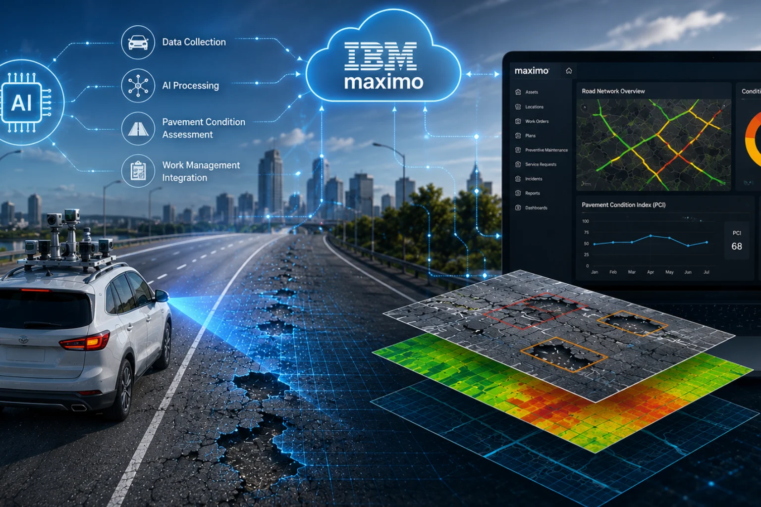
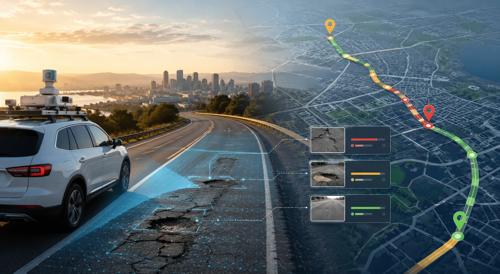
AI road survey software uses dashcams or vehicle-mounted cameras combined with artificial intelligence and computer vision to inspect roads automatically.
Instead of relying on expensive specialized vehicles, ordinary fleet vehicles equipped with cameras can continuously collect roadway footage during regular operations. AI models then analyze the video to detect:
The collected data is geo-tagged, mapped, and converted into actionable maintenance insights.
This approach has become increasingly popular because it allows continuous monitoring without disrupting traffic or requiring highly specialized hardware.
LiDAR (Light Detection and Ranging) uses laser pulses to create highly accurate 3D representations of road surfaces and surrounding infrastructure.
LiDAR survey vehicles typically include:
As the vehicle moves, the LiDAR system measures distances by calculating how long laser pulses take to bounce back from surfaces. The result is a dense 3D point cloud that captures road geometry with extreme precision.
LiDAR is commonly used for:
Because of its precision, LiDAR has traditionally been the preferred technology for complex infrastructure projects.
One of the biggest differences between the two technologies is cost.
A digital road survey system based on dashcams requires relatively low-cost hardware. Existing fleet vehicles such as buses, maintenance vans, taxis, or inspection vehicles can be converted into data collection units.
This dramatically lowers:
LiDAR systems are significantly more expensive. Specialized survey vehicles often cost hundreds of thousands of dollars due to advanced sensors and calibration requirements.
In addition, LiDAR surveys require:
For agencies with limited budgets, scaling LiDAR across large road networks can become difficult.
LiDAR excels in geometric precision. It captures accurate elevation, depth, and spatial measurements in 3D environments.
This makes it ideal for:
While dashcam systems may not match LiDAR’s engineering-grade depth precision, modern AI models have become highly effective at visual defect detection.
For many routine inspections, road condition monitoring AI systems can accurately identify:
For surface-level condition assessment, Dashcam AI often provides sufficient accuracy at a fraction of the cost.
Scalability is where automated road survey technology powered by dashcams becomes extremely powerful.
Since ordinary vehicles can collect data continuously, agencies can monitor thousands of kilometers more frequently.
This enables:
Road networks no longer need to wait months or years for inspection cycles.
LiDAR surveys are typically periodic rather than continuous due to operational costs and limited vehicle availability.
As a result:
LiDAR generates massive 3D point cloud datasets that require:
Processing and interpreting LiDAR data can take significant time.
Modern road video analytics software automates much of the analysis process using AI.
The system can automatically:
This reduces manual effort and speeds up decision-making.
AI road inspection systems are ideal for:
Dashcam AI works especially well for organizations prioritizing operational efficiency and scalability.
LiDAR remains highly valuable for:
For projects where centimeter-level spatial accuracy is critical, LiDAR is often necessary.
Not entirely.
The two technologies are better viewed as complementary rather than competitive.
LiDAR remains unmatched for highly detailed spatial measurements and advanced engineering analysis. However, many transportation agencies are realizing that they do not need expensive LiDAR surveys for every routine road inspection task.
In reality, a large percentage of road maintenance decisions are based on visible surface conditions rather than deep structural measurements.
This is where AI road condition assessment software offers enormous value:
For everyday pavement monitoring and roadway asset management, AI-powered camera systems are increasingly becoming the preferred solution.
Transportation agencies worldwide are moving toward intelligent infrastructure monitoring systems that prioritize:
AI-powered survey platforms can now detect and classify road defects with impressive reliability while continuously learning from new data.
The combination of:
is helping agencies transition from reactive maintenance to proactive infrastructure management.
This shift is particularly important as road networks continue expanding while maintenance budgets remain constrained.
Choosing between Dashcam AI and LiDAR depends on your operational goals, budget, and survey requirements.
If your priority is:
LiDAR remains a powerful solution.
But if your focus is:
then dashcam road survey AI is often the smarter and more scalable choice.
For many agencies, the future lies in combining both technologies strategically — using LiDAR for specialized engineering work and AI-powered dashcam systems for routine network-wide monitoring.
RoadVision AI helps road authorities, consultants, and infrastructure companies modernize road inspections through AI-driven pavement and roadway intelligence.
The platform enables:
Using simple dashcam footage and AI-powered analytics, RoadVision AI transforms ordinary vehicles into scalable road monitoring systems.
If your organization wants to improve inspection efficiency, reduce operational costs, and move toward smarter infrastructure management, you can explore a personalized demo to see how AI-powered road intelligence works in real-world conditions.
Book a demo with RoadVision AI to experience the future of intelligent road surveying.
The main difference is that dashcam road survey AI uses vehicle-mounted cameras and computer vision to detect visible road defects, while LiDAR uses laser scanning to create highly accurate 3D spatial maps. Dashcam AI is more affordable and scalable for routine inspections, whereas LiDAR is better suited for engineering-grade measurements and detailed infrastructure modeling.
Yes. Modern AI road inspection systems and road condition monitoring AI platforms can accurately detect pavement cracks, potholes, rutting, surface wear, lane marking damage, and roadside asset issues using standard dashcam footage. For routine maintenance planning and large-scale network monitoring, Dashcam AI often provides sufficient accuracy at a significantly lower cost than LiDAR.
The right choice depends on the project requirements. LiDAR is ideal for projects requiring high-precision 3D mapping, terrain analysis, and engineering surveys. However, for scalable roadway inspections, automated pavement assessments, continuous monitoring, and cost-efficient infrastructure management, AI-powered road survey software using dashcams is often the more practical and scalable solution.

The Autonomous Road Engineer
AI that is transforming road infrastructure, from reactive to predictive.
.webp)