Road accidents rarely happen randomly. Most crashes occur repeatedly at specific locations due to poor road geometry, speeding patterns, visibility limitations, traffic conflicts, or infrastructure failures. Traditionally, identifying these dangerous zones required years of manual surveys, police reports, and reactive safety audits.
Today, AI-powered accident blackspot analysis is transforming how governments, highway authorities, and smart cities detect and prevent crashes before they escalate into major safety concerns.
Using AI-based crash hotspot detection, computer vision, geospatial analytics, and predictive modeling, transportation agencies can now identify dangerous corridors in real time and take proactive action.

AI-powered accident blackspot analysis refers to the use of artificial intelligence, machine learning, GIS mapping, and traffic analytics to identify locations with high accident probability.
Unlike traditional approaches that rely only on historical crash records, modern intelligent transportation safety analytics combine multiple data sources including:
This creates a far more accurate and scalable digital crash mapping platform capable of detecting hidden risk patterns across highways, urban roads, intersections, and construction zones.
Conventional accident investigations are often reactive. Authorities typically wait until repeated fatalities occur before labeling a road segment as dangerous.
This creates several challenges:
Modern road networks require predictive transportation analytics rather than static reporting systems.
This is where AI-driven road safety insights deliver major advantages.
AI systems process massive amounts of structured and unstructured transportation data within minutes.
Using automated accident data analytics, the platform can analyze:
This allows authorities to prioritize interventions faster and more accurately.
Modern transportation agencies increasingly rely on real-time accident monitoring systems to identify emerging hazards before severe crashes occur.
AI continuously evaluates:
This creates a proactive AI-based collision hotspot detection framework instead of relying solely on historical data.
One of the biggest breakthroughs in modern road safety is predictive accident risk modeling.
AI models can forecast future crash probability by studying historical incidents alongside live roadway conditions.
These systems use:
As a result, authorities gain access to a powerful predictive crash intelligence platform capable of identifying high-risk zones before fatal incidents occur.
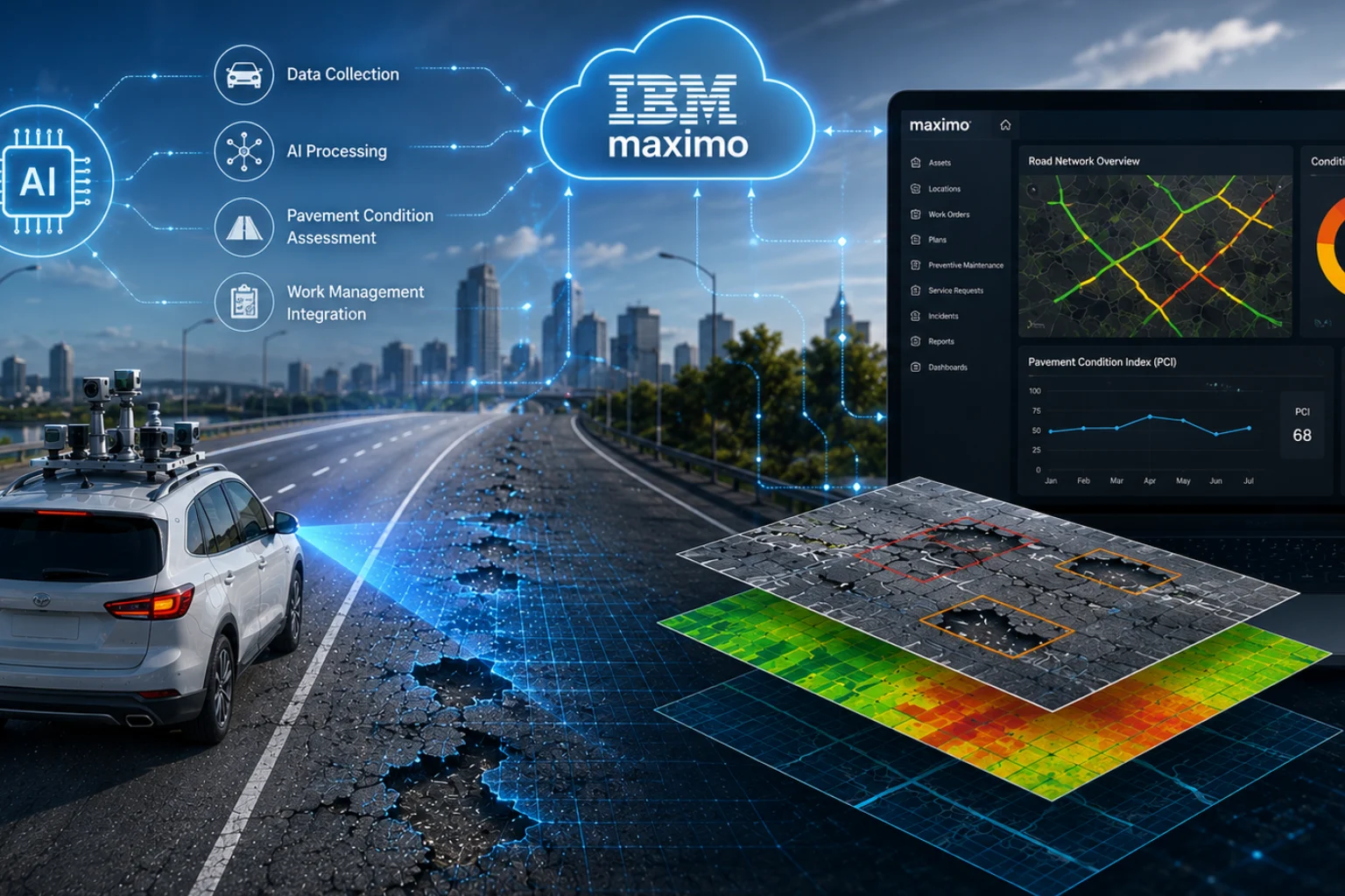
Traditional spreadsheets and static maps are being replaced by advanced digital traffic incident analytics systems.
AI-powered dashboards now provide:
This enables faster decision-making through AI-supported crash data visualization tools.
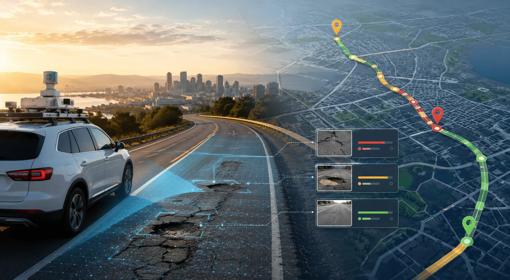
Road hazards such as potholes, faded lane markings, broken barriers, shoulder erosion, and drainage failures significantly contribute to accidents.
Using computer vision, automated road hazard mapping systems can identify infrastructure defects in real time.
These insights support:
This creates a stronger intelligent infrastructure risk analytics ecosystem for transportation authorities.
Highways experience unique risk factors including:
Modern smart highway accident intelligence systems use AI cameras, drone surveys, and roadway sensors to continuously monitor highway safety conditions.
Combined with AI-based traffic risk mapping, these systems improve response planning and corridor safety management.
Not all accidents carry the same risk level.
Advanced AI models now enable intelligent crash severity prediction by analyzing:
Authorities can prioritize high-fatality-risk locations using AI-driven fatality risk assessment models.
Urban mobility introduces complex interactions between:
Using smart urban crash monitoring, cities can identify dangerous intersections, illegal turning patterns, and pedestrian conflict zones more efficiently.
This supports safer smart city planning and improved traffic engineering.
Modern cities are increasingly adopting AI-enabled transportation safety systems to improve mobility and reduce fatalities.
These solutions integrate:
Together, they create a connected intelligent public safety monitoring ecosystem.
The adoption of AI-based accident prevention systems delivers significant operational and social benefits.
AI detects accident trends far earlier than manual audits.
Authorities can intervene proactively before repeated crashes occur.
Transportation agencies gain accurate insights for long-term improvements.
Preventive maintenance and smarter resource allocation reduce operational costs.
AI systems can monitor thousands of kilometers simultaneously.
The future of transportation safety will increasingly depend on:
As infrastructure becomes more connected, AI will evolve into a central component of every intelligent crash analytics solution.
Transportation agencies that adopt advanced road safety intelligence today will be better equipped to reduce fatalities, improve mobility, and optimize infrastructure investments.
The future of transportation safety lies in proactive intelligence, not reactive investigation. With advancements in AI-powered accident blackspot analysis, authorities can now identify dangerous road segments before repeated crashes occur.
From predictive accident risk modeling and AI traffic risk mapping to automated road hazard mapping and real-time accident monitoring systems, artificial intelligence is transforming how roads are monitored, maintained, and secured.
As governments and highway agencies move toward smarter infrastructure, the need for scalable and intelligent roadway monitoring will continue to grow. This is where RoadVision AI is helping redefine the future of transportation safety.
RoadVision AI is building autonomous road engineers powered by advanced computer vision, AI analytics, GIS intelligence, and predictive roadway monitoring technologies. The platform enables transportation agencies, highway operators, smart cities, and infrastructure consultants to automate road inspections, detect safety risks, analyze crash hotspots, and improve roadway decision-making at scale.
By combining AI-driven road safety insights, intelligent transportation safety analytics, and automated roadway intelligence, RoadVision AI helps organizations reduce fatalities, optimize maintenance planning, and build safer transportation networks.
Want to see how AI can transform roadway safety monitoring and accident blackspot analysis?
Book a demo with RoadVision AI to explore how autonomous roadway intelligence can help your organization detect risks faster, improve safety compliance, and make smarter infrastructure decisions.
AI-powered accident blackspot analysis uses artificial intelligence, machine learning, GIS mapping, and traffic analytics to identify accident-prone road locations and predict future crash risks more accurately than traditional methods.
AI-based crash hotspot detection analyzes traffic patterns, accident history, vehicle speeds, road conditions, and real-time roadway data to identify locations with a high probability of accidents or near-miss incidents.
Predictive accident risk modeling helps transportation agencies proactively identify dangerous road segments, reduce fatalities, optimize maintenance budgets, improve infrastructure planning, and enhance public safety.

The Autonomous Road Engineer
AI that is transforming road infrastructure, from reactive to predictive.
.webp)