India's rural road network forms the lifeline of village connectivity, agricultural logistics, and regional accessibility. With crores of residents relying on these roads daily, ensuring their durability and safety is critical. Compliance with IRC SP 50, the guiding document from the Indian Roads Congress for rural road design and maintenance, is essential for delivering predictable performance and reliable rural mobility.
However, traditional inspection methods—manual assessments, survey vans, and paper-based reporting—often fall short in speed, accuracy, and scalability. This is where smartphone-based road surveys and AI-powered app-based inspections are changing the game. In a sector where "a stitch in time saves nine," these digital tools provide exactly the timely intelligence needed.
Rural roads under programmes like Pradhan Mantri Gram Sadak Yojana (PMGSY) must be monitored frequently to uphold quality and safety standards. Yet most districts face constraints:
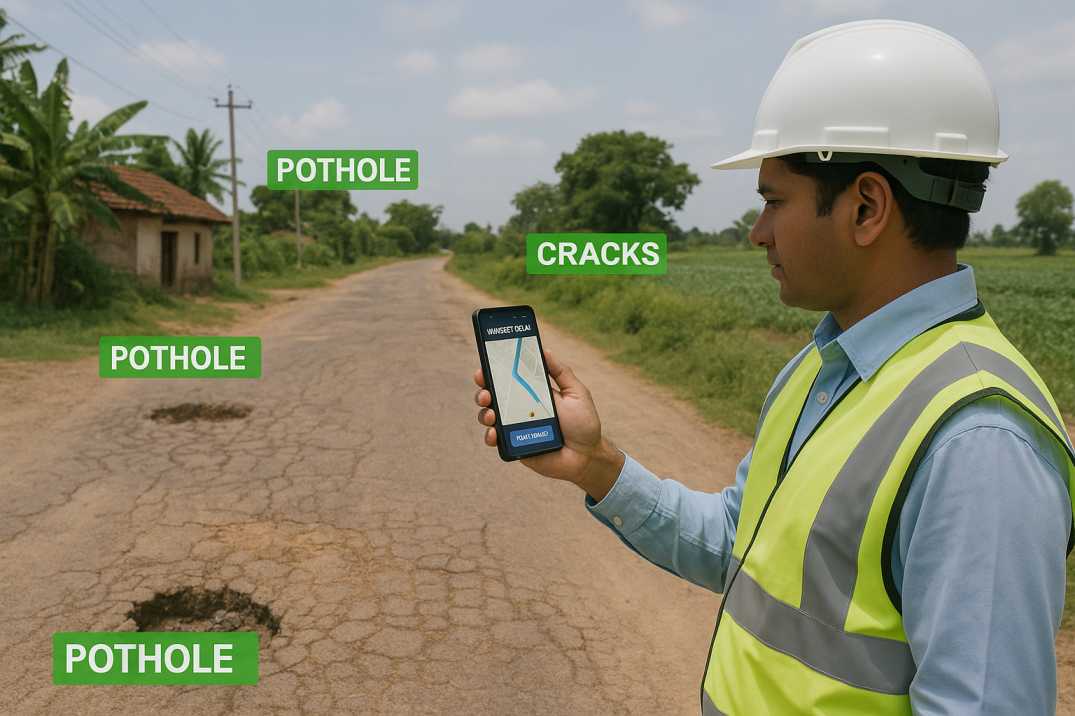
Smartphone-based inspections tackle these constraints head-on. With just an Android device mounted inside a moving vehicle, field teams can capture high-resolution video, geotag locations, and record road condition data instantly. When powered by AI-based analysis, these inspections help classify distresses, detect potholes, evaluate drainage performance, and generate automated condition reports—all mapped to IRC SP 50 requirements.
This approach aligns perfectly with India's push toward Digital India, transparent monitoring, and data-driven public infrastructure management.
IRC SP 50 lays down detailed requirements to ensure safe and long-lasting rural roads. Key principles include:
2.1 Context-Appropriate Geometric Design
Roadway width, sight distance, curvature, gradients, and camber must suit low-volume rural traffic and local terrain conditions, ensuring safe operation at design speeds.
2.2 Pavement Layering and Material Specifications
Selection of subgrade materials, granular layers, and surfacing must follow IRC standards for performance and durability under local traffic and climate conditions.
2.3 Shoulder and Cross-Drainage Design
Proper shoulder construction, side drains, and cross-drainage structures ensure all-weather accessibility and prevent water damage to pavement edges.
2.4 Drainage Efficiency
Surface and sub-surface drainage must prevent water stagnation—one of the biggest threats to pavement life in monsoon-prone rural areas.
2.5 Long-Term Performance Monitoring
Regular inspections, maintenance planning, and periodic condition surveys are mandatory for sustained service levels and timely interventions.
2.6 Safety Provisions
Adequate signage, crash barriers at hazardous locations, and pedestrian facilities near villages must be incorporated and maintained.
To meet these principles, authorities require consistent, scalable, and objective monitoring—something manual methods often struggle to deliver.
Platforms like RoadVision AI bring best practices to life through automation, digitalization, and intelligent analytics using its integrated suite of AI agents.
3.1 Smartphone-Based Road Assessments Aligned with IRC SP 50
The Pavement Condition Intelligence Agent app captures continuous road video and sensor data using standard smartphones. This enables:
3.2 AI-Driven Pavement Condition Survey
Using computer vision, RoadVision AI automatically detects:
These are directly compared to IRC SP 50 thresholds, ensuring immediate compliance checks and severity classification.
3.3 Road Inventory and Digital Twins
Digital twins generated through the Roadside Assets Inventory Agent allow engineers to:
This transforms rural road maintenance from reactive patchwork to proactive planning.
3.4 Traffic Surveys for Load Assessment
With the Traffic Analysis Agent, authorities can assess:
These insights support pavement design and maintenance decisions in line with IRC guidance.
3.5 Integrated Road Safety Audits
The Road Safety Audit Agent evaluates:
3.6 Automated Reporting and Compliance Documentation
The platform generates:
In short, RoadVision AI turns smartphones into powerful compliance and planning tools that put actionable intelligence in the hands of every engineer.
Despite advancements, rural road management faces inherent challenges:
4.1 Diverse Geographies
Hilly regions, black cotton soil zones, flood-prone areas, and forests demand different inspection strategies and distress patterns that AI must be trained to recognize.
4.2 Budget Constraints
Many districts operate with limited maintenance budgets, making costly technologies impractical—but smartphone-based solutions are accessible to all.
4.3 Skilled Workforce Shortage
Not all regions have access to trained pavement engineers who can interpret complex condition data. AI simplifies this with automated scoring and recommendations.
4.4 Infrequent Monitoring
Traditional inspections tend to be periodic rather than continuous, causing delayed interventions when problems escalate. Smartphone surveys enable more frequent checks.
4.5 Connectivity in Remote Areas
Many rural locations have poor internet connectivity. RoadVision AI supports offline data capture with automatic synchronization when connectivity returns.
4.6 Variability in Smartphone Quality
Different devices have varying camera quality. The platform includes calibration routines to ensure consistent data regardless of device.
These challenges make smartphone-based and AI-driven solutions not just beneficial—but indispensable for achieving IRC SP 50 compliance at scale.
India's rural roads are the arteries of economic growth. Ensuring their long-term health under IRC SP 50 demands timely data, actionable insights, and scalable monitoring systems. Smartphone-based road surveys and AI-powered inspections represent the future of rural road asset management—fast, cost-effective, and compliant with national standards.
RoadVision AI is at the forefront of this transformation. By combining digital twins, advanced computer vision, and AI-based road safety audits through the Pavement Condition Intelligence Agent, Roadside Assets Inventory Agent, Road Safety Audit Agent, and Traffic Analysis Agent, the platform streamlines detection of potholes, cracks, drainage failures, and structural distresses. Its alignment with IRC SP 50 and other IRC Codes helps engineers and government agencies:
Truly a case of "working smarter to travel farther"—ensuring that every rupee invested in rural roads delivers maximum benefit to the communities they serve.
If your department or agency aims to enhance compliance, strengthen audit readiness, and modernize rural road maintenance, book a demo with RoadVision AI today and discover how smartphone-based surveys can transform your approach to rural road asset management.
Q1. What is IRC SP 50 used for?
IRC SP 50 is used for designing and maintaining rural roads in India, especially under low-volume traffic conditions.
Q2. Are smartphone-based inspections accepted for government road audits?
Yes, many state PWDs and PMGSY bodies are now adopting mobile-based inspections for their cost-efficiency and accuracy.
Q3. How accurate is AI mobile road assessment in rural conditions?
Modern AI tools like RoadVision are trained on Indian road types and can detect even early-stage surface distresses accurately.

The Autonomous Road Engineer
AI that is transforming road infrastructure, from reactive to predictive.

.webp)