Cities around the world are expanding rapidly, and with this growth comes increasing pressure on urban infrastructure. Roads—often referred to as the lifelines of modern cities—support the movement of millions of people, goods, and services every day. However, maintaining these networks requires accurate and up-to-date data on road conditions. Without reliable information, cities risk facing mobility disruptions, safety hazards, and rising maintenance costs. Traditional road surveys once relied on manual inspections, paper documentation, and slow reporting cycles. Today, technological innovation is transforming how cities collect and analyze road data. Intelligent platforms such as AI-powered road infrastructure intelligence systems are enabling faster, more accurate, and scalable road surveys using computer vision, geospatial analytics, and predictive infrastructure insights.

Road surveys form the foundation of effective infrastructure planning and maintenance. They help authorities understand the current state of road networks and identify areas requiring attention.
Key aspects assessed during road surveys include:
• pavement condition and surface quality
• cracks, potholes, and rutting
• road geometry and intersections
• signage visibility and compliance
• sidewalks, drainage systems, and supporting infrastructure
Technologies such as AI-powered road network monitoring platforms help authorities continuously track road conditions across large urban networks.
Accurate survey data allows cities to move from reactive repairs toward proactive infrastructure management.
Road survey methodologies are typically guided by national infrastructure standards. In India, the Indian Roads Congress (IRC) provides comprehensive guidelines for road condition evaluation and safety assessments.
Codes such as IRC:82 and IRC:SP-16 provide frameworks for identifying pavement distresses including cracks, potholes, rutting, and surface deterioration.
Uniform definitions for crack types, pothole sizes, and edge failures ensure consistent evaluations across different road segments.
Structured scoring systems allow engineers to compare pavement performance across time and locations.
Inspection platforms such as AI-powered pavement condition intelligence systems help automate these assessments.
Road surveys also analyze curves, gradients, intersections, sight distances, and lane visibility to identify potential safety risks.
Proper drainage plays a critical role in pavement durability, as poor water flow accelerates surface deterioration.
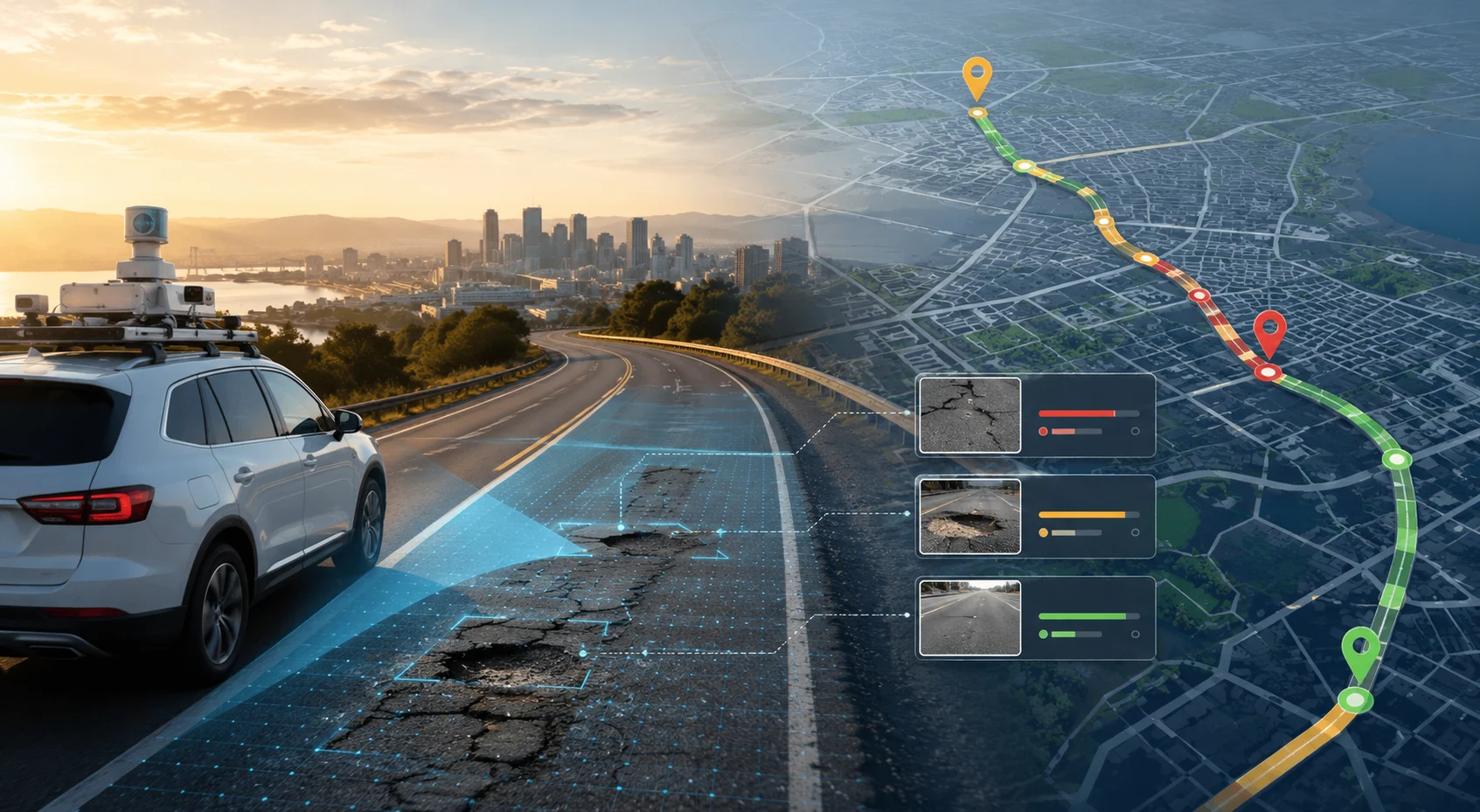
Artificial Intelligence has significantly improved the speed, accuracy, and scalability of road surveys.
AI models analyse imagery captured by cameras mounted on vehicles, drones, or smartphones.
Common defects detected include:
• longitudinal and transverse cracks
• potholes and depressions
• surface raveling
• rutting and texture loss
Inspection tools such as AI-powered rapid road damage detection systems provide fast and accurate defect identification.
Each detected defect is mapped to precise geographic coordinates, allowing engineers to visualize problem areas on interactive maps.
Machine learning algorithms analyse deterioration patterns and forecast future pavement conditions.
This enables road agencies to perform maintenance before failures occur.
AI systems can also evaluate road curves, lane markings, and traffic signage.
Infrastructure monitoring tools such as AI-powered roadside infrastructure inventory platforms help maintain accurate digital records of roadside assets.
Survey results are integrated into digital dashboards that provide decision-makers with comprehensive infrastructure insights.
Traffic monitoring technologies such as AI-powered traffic analysis platforms can further enhance urban mobility planning.
Cities that successfully manage road infrastructure typically adopt technology-driven survey strategies.
Regular automated surveys ensure that road condition data remains current and reliable.
Combining dashcams, drones, and mobile sensors provides comprehensive infrastructure coverage.
Using structured scoring systems allows authorities to compare pavement conditions across different regions and time periods.
Maintenance planning based on predictive analytics helps prevent costly infrastructure failures.
Seamless integration between survey platforms and municipal systems ensures better coordination and infrastructure visibility.
Cities relying on outdated survey methods often encounter several operational challenges.
Infrequent surveys result in incomplete or outdated road condition information.
Undetected defects or geometric issues may contribute to road accidents.
Without accurate data, maintenance funds may be misallocated.
Manual surveys create weak documentation and limited audit trails.
Large urban road networks require scalable inspection technologies that manual teams cannot easily provide.
AI-powered survey systems address these limitations by delivering fast, objective, and scalable infrastructure monitoring.
Road surveys may not always receive public attention, but they form the foundation of safe and efficient transportation systems. When supported by modern technologies such as Artificial Intelligence and geospatial analytics, road surveys become powerful tools for infrastructure planning and public safety.
By automating inspections, detecting pavement defects early, and enabling predictive maintenance strategies, AI-driven survey systems allow cities to manage road networks more effectively. The result is improved mobility, enhanced safety, and optimized infrastructure investments.
Platforms such as RoadVision AI bring together computer vision, GIS mapping, predictive analytics, and digital infrastructure monitoring into a single unified solution. With these technologies, cities can move beyond reactive maintenance and build smarter, safer, and more resilient transportation networks for the future.
Because in the journey toward sustainable urban mobility, better road intelligence leads to better cities.
Modern road surveys help detect unsafe curves, missing signs, and pavement issues early. This enables cities to act preventively rather than reactively, reducing traffic incidents.
Yes. Whether you're managing a large urban network or a small town, RoadVision AI scales easily and helps all municipalities modernize their road asset strategies.

The Autonomous Road Engineer
AI that is transforming road infrastructure, from reactive to predictive.
.webp)