Road networks are among the most critical infrastructure assets in any country. They connect cities, enable commerce, support emergency services, and directly impact public safety. Yet maintaining roads efficiently remains one of the most resource-intensive challenges for government agencies and highway authorities worldwide.
Traditional road inspection methods — relying on field engineers, manual observations, and paper-based reporting — are too slow, too expensive, and too inconsistent to keep pace with expanding road networks. That is why transportation departments, national highway agencies, and infrastructure companies are rapidly adopting AI road survey software to modernise how roads are inspected, monitored, and managed.
This guide explains everything you need to know about AI-powered road inspection — how it works, which technologies it uses, how it compares to traditional methods, and why agencies from NHAI to municipal corporations are making the switch.
AI road survey software is a technology platform that uses Artificial Intelligence, computer vision, and machine learning to automatically inspect, assess, and monitor road conditions — replacing or augmenting manual field surveys.
Instead of sending engineering teams to physically walk or drive road sections and document defects by hand, AI systems analyse visual data collected from:
The software processes this data and automatically detects road defects, measures pavement condition, identifies roadside assets, and generates actionable reports — all at a fraction of the time and cost of manual surveys.
In practical terms, AI road survey software acts as a digital road engineer — one that can inspect thousands of kilometres continuously without fatigue, subjectivity, or scheduling delays.
Manual road inspections have served the industry for decades, but they are increasingly unable to scale. Here is why transportation agencies are looking for alternatives.
India alone has over 63 lakh kilometres of road network, making it the second-largest in the world. Surveying even a fraction of this manually requires large field teams, specialised vehicles, and extended inspection cycles that can take weeks or months.
Two engineers assessing the same road section may classify the same crack differently — one as minor surface cracking, another as structural distress requiring urgent repair. This inconsistency in road condition reporting undermines maintenance prioritisation and budget planning.
Traditional road surveys involve substantial expenditure across:
As road networks expand, these costs scale proportionally — making comprehensive network-wide surveys prohibitively expensive.
Road conditions deteriorate quickly due to heavy vehicle loads, monsoon damage, frost cycles, and ageing substructure. Annual or biannual inspections routinely miss emerging defects before they escalate into safety hazards or costly emergency repairs.
Paper-based inspection records are difficult to analyse, compare over time, or share with decision-makers. Without structured digital data, predictive road maintenance is nearly impossible.
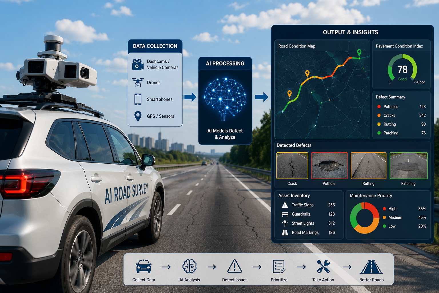
Modern AI-powered road inspection systems follow a structured, repeatable workflow that transforms raw visual data into structured maintenance intelligence.
The survey begins with capturing high-quality visual and location data across the road network. Common collection methods include:
The advantage of AI road survey tools like RoadVision AI is that data collection requires no specialist equipment — a vehicle with a standard dashcam can generate survey-grade intelligence.
Raw footage is prepared for AI analysis through automated preprocessing steps:
This is where AI road survey software delivers its core value. Computer vision and deep learning models analyse each frame and automatically identify:
Leading road crack detection AI systems can detect surface defects as fine as a few millimetres and classify them by type and severity — far exceeding human visual inspection.
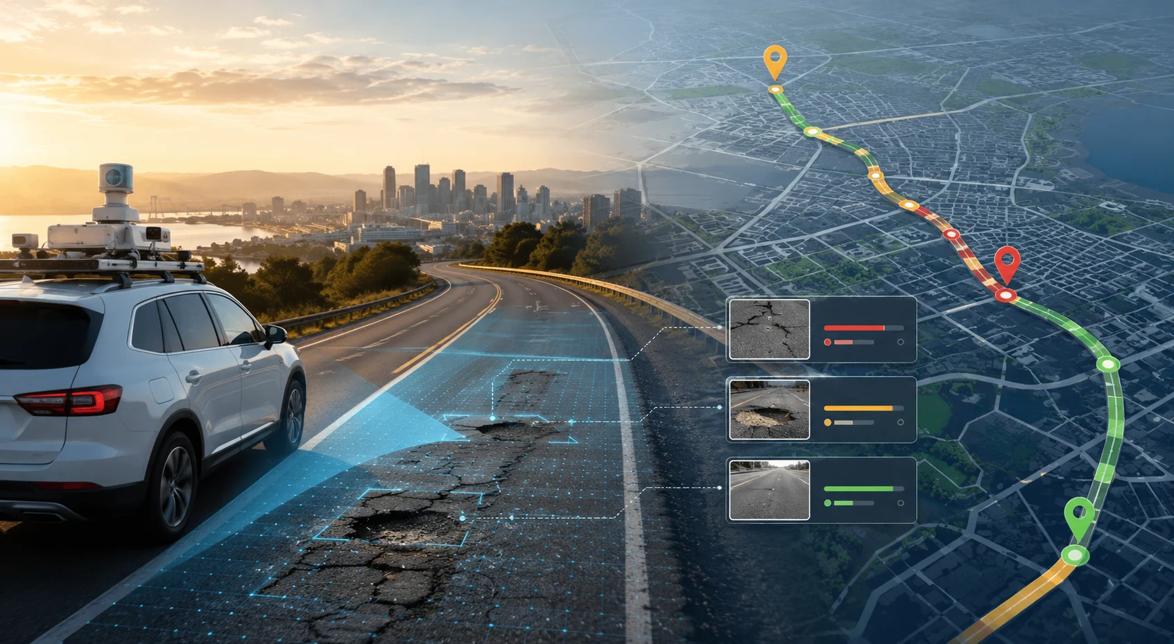
All detected defects and assets are geo-tagged and plotted on interactive GIS maps. The system automatically generates:
Several advanced technologies work in combination to make AI road survey software accurate, scalable, and reliable.
Computer vision enables machines to interpret images and video at pixel level. It is the core technology behind automated detection of pavement distress types, road asset inventory, and safety feature identification.
Machine learning models trained on large, labelled road datasets improve detection accuracy over time. Deep learning, particularly convolutional neural networks (CNNs), powers recognition of complex defect patterns across varying road surface conditions, lighting conditions, and weather scenarios.
GIS technology integrates road condition data with location intelligence, allowing infrastructure teams to visualise defects geographically, track deterioration trends across time, and prioritise maintenance by corridor or zone.
The latest generation of road infrastructure AI platforms goes beyond detection to autonomous decision-making. Agentic AI systems like RoadVision AI combine vision intelligence with language intelligence — enabling the platform to not just detect defects but reason about them, generate maintenance recommendations, and communicate findings in plain language to engineers and decision-makers.
Pavement condition monitoring is the most common application of AI road survey technology. Using automated pavement condition index software, agencies can generate PCI scores across entire networks without manual measurement teams — enabling data-driven maintenance budgeting and prioritisation.
RoadVision AI's Pavement Condition Intelligence Agent automates PCI data collection and scoring from standard dashcam video, delivering network-wide pavement health maps within days of data collection.
AI systems excel at detecting the full range of pavement distress types defined in standards such as ASTM D6433 and IRC guidelines — including potholes, cracking, rutting, and surface wear. AI pothole detection software enables road agencies to identify damage earlier, respond faster, and reduce the escalation of minor defects into major structural failures.
For rapid damage assessment after natural disasters or extreme weather events, RoadVision AI's Rapid Road Damage Assessment Agent provides emergency condition mapping within hours.
Every road network contains hundreds of assets per kilometre — signboards, guardrails, streetlights, utility poles, drainage structures, and more. AI-powered road asset inventory management software identifies and catalogues these assets automatically from survey video, eliminating the need for separate, manual inventory surveys.
RoadVision AI's Roadside Assets Inventory Agent builds a complete, GPS-tagged digital asset register from a single dashcam drive.
AI-based road safety inspection software detects missing signs, poor visibility zones, inadequate barriers, and dangerous road geometry features that create accident risk. Combined with accident history data, these systems can proactively identify emerging blackspot locations before accident clusters form.
RoadVision AI's Blackspot Analysis Agent maps accident-prone zones using AI analysis of road features and historical incident data.
AI traffic analysis software automates vehicle detection, classification, and counting from camera footage — replacing expensive manual Traffic Volume Counts (TVC). For NHAI projects and state highway DPRs requiring traffic data, AI-based systems deliver faster, more consistent vehicle classification aligned with IRC standards.
RoadVision AI's Traffic Analysis Agent performs 24/7 automated traffic monitoring including PCU computation, vehicle classification, and congestion analysis.
AI road inspection software can process and report on road sections that would take field teams weeks to inspect — often within 24 to 48 hours of data collection. This speed enables more frequent surveys and faster response to emerging conditions.
Automated systems eliminate inspector subjectivity. Every road section is assessed using the same AI model, the same defect classification criteria, and the same reporting format — producing consistent, comparable data across networks, years, and survey cycles.
By reducing dependence on large field survey teams and specialised equipment, AI-based road condition monitoring typically delivers cost savings of 60–80% compared to traditional survey methods, while covering more road network per survey cycle.
Unlike periodic manual surveys, AI systems can operate continuously — using fleet vehicle dashcams, roadside CCTV, or drone patrols to provide near real-time road condition intelligence. This is especially valuable for high-traffic corridors, post-monsoon assessment, and highways under maintenance contracts.
The shift from reactive to predictive road maintenance is one of the highest-value outcomes of AI road survey adoption. By tracking pavement condition trends over time, AI platforms forecast which sections will deteriorate to critical condition within a defined period — enabling proactive intervention before expensive structural failure occurs.
By reducing the need for engineers to conduct on-foot or slow-speed vehicle inspections on live traffic roads, AI road survey software significantly reduces field crew exposure to road accident risk.
India's road sector faces a unique combination of scale, diversity, and urgency. With the world's second-largest road network spanning national highways, state highways, district roads, and PMGSY rural roads, manual inspection at scale is simply not feasible.
AI road survey software is well-suited to Indian road conditions because:
RoadVision AI is purpose-built for the Indian road infrastructure context — combining Agentic AI with deep knowledge of IRC standards, NHAI processes, and the operational realities of state PWD and municipal road management.
AI road survey technology is advancing rapidly. Key developments expected to shape the next generation of road inspection include:
Self-driving survey platforms capable of conducting road inspections independently, 24/7, without driver intervention — dramatically increasing network coverage and monitoring frequency.
AI systems that continuously model pavement deterioration trajectories across entire national networks — enabling long-range maintenance budgeting and infrastructure investment planning based on data, not estimation.
The most advanced road infrastructure AI platforms are moving beyond single-use tools to end-to-end intelligence systems — combining pavement condition, asset inventory, safety audits, traffic analysis, and maintenance workflow automation in a single integrated platform. This is the direction RoadVision AI is building toward with its suite of Agentic AI agents for road engineering.
AI road survey software is not a future technology — it is being deployed right now by road agencies, national highway authorities, and infrastructure companies to transform how road networks are inspected, managed, and maintained.
The shift from manual, reactive inspection to AI-powered predictive road maintenance delivers faster surveys, lower costs, consistent data, and smarter infrastructure decisions — at scale.
RoadVision AI is building the world's first Autonomous Road Engineers using Agentic AI technology designed specifically for road infrastructure. The platform combines vision intelligence and language intelligence to automate pavement condition surveys, roadside asset inventory, road safety audits, blackspot analysis, and traffic monitoring — all from dashcam video and visual data.
Whether you manage national highways, state roads, or city streets, RoadVision AI enables your organisation to move from reactive guesswork to data-driven road engineering.
Book a Demo with RoadVision AI and see how intelligent road survey software can transform your infrastructure management.
Q1. What is AI road survey software?
AI road survey software uses computer vision and machine learning to automatically detect road defects — such as potholes, cracks, and rutting — from dashcam or drone video. It replaces or supplements manual inspection with automated, GIS-mapped reports that help engineers prioritise maintenance.
Q2. How accurate is AI-based road inspection?
Modern AI road inspection platforms achieve 85–95% defect detection accuracy for common distress types. Independent testing by road authorities (including the Danish Road Directorate in 2025) has shown AI systems matching laser-scan accuracy with under 1% variation in condition measurements.
Q3. Is AI road survey software suitable for Indian roads and NHAI projects?
Yes. AI road survey platforms are fully applicable to NHAI national highways, PMGSY rural roads, and state PWD networks. They can be configured to detect distress types per IRC standards and generate pavement condition scores aligned with Indian road management guidelines.

The Autonomous Road Engineer
AI that is transforming road infrastructure, from reactive to predictive.
.webp)