Canada's highway network is the backbone of national mobility—linking remote communities, enabling economic activity, supporting freight movement, and connecting coast to coast through some of the world's most challenging terrain. Yet, with long travel distances, severe winter weather, wildlife presence, and high-speed corridors, roadside hazards can emerge "in the blink of an eye."
Ensuring early identification of risks is more than operational housekeeping—it is a critical pillar of public safety. As transportation agencies seek smarter, more proactive approaches, AI-enabled roadside hazard detection is quickly becoming a game-changer for modern road management in Canada.
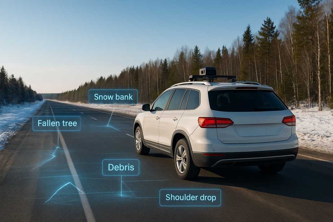
Traditional patrol-based inspections are labour-intensive, weather-dependent, and limited by visibility and human factors. In a country where snowstorms, freeze–thaw cycles, drifting wildlife, and shifting shoulder conditions are routine, hazards don't wait for scheduled inspections.
AI solves this scale and speed challenge by enabling continuous monitoring, rapid analysis, and automated detection through the Road Safety Audit Agent. As the saying goes, "A stitch in time saves nine"—early warning prevents bigger problems, costly repairs, and life-threatening situations on high-speed corridors.
2.1 Common Roadside Hazards
2.2 High-Risk Locations
2.3 Seasonal Variations
While Canada's federal, provincial, and territorial road authorities lead with national safety frameworks, many engineering principles also align with internationally recognised road-safety guidelines, including the structured risk-based methodologies often seen in IRC-style codes. These frameworks emphasise:
AI through the Pavement Condition Intelligence Agent and Road Safety Audit Agent strengthens these principles by providing high-frequency data, automated classification, and predictive insights across entire road networks.
4.1 Trans-Canada Highway (British Columbia)
4.2 Ontario 400-Series Highways
4.3 Quebec Autoroutes
4.4 Prairie Highways (Alberta, Saskatchewan, Manitoba)
4.5 Maritime Highways (New Brunswick, Nova Scotia, PEI)
4.6 Northern Routes (Yukon, Northwest Territories, Nunavut)
RoadVision AI integrates advanced computer vision, machine learning, and digital road-monitoring systems through its integrated suite of AI agents to operationalise modern road-safety standards with precision.
5.1 Real-Time Hazard Identification
The Road Safety Audit Agent analyses high-resolution video streams and sensor inputs continuously to detect:
This immediate visibility ensures engineers can act fast—because on Canadian highways, minutes can make all the difference.
5.2 Winter-Condition Intelligence
Canadian winters are unforgiving, and RoadVision AI is designed to meet this reality head-on. The system flags:
By supporting winter operations teams, AI turns what was once a reactive process into a proactive safety shield.
5.3 Predictive Safety Modelling
The Traffic Analysis Agent analyses historical roadway, crash, weather, and traffic datasets to forecast future hazard hotspots. This helps agencies:
5.4 Wildlife and Object Detection
Remote corridors and forested regions often experience wildlife intrusions. The Road Safety Audit Agent detects:
Alerts operators in real time, helping reduce collisions and improve emergency responsiveness.
5.5 Integrated Pavement and Inventory Assessment
Beyond hazards, the platform conducts precise pavement condition surveys through the Pavement Condition Intelligence Agent and road-inventory inspections via the Roadside Assets Inventory Agent. This holistic visibility allows agencies to assess structural integrity and safety conditions simultaneously—one unified workflow, multiple safety wins.
5.6 Post-Storm Rapid Assessment
Following winter storms or extreme weather, AI enables:
5.7 Work Zone Hazard Monitoring
During construction and maintenance, AI monitors:
While AI offers significant advantages, effective integration requires tackling several real-world considerations:
6.1 Data Quality
Visibility, snow cover, and sensor limitations can affect detection accuracy.
AI Solution: Adaptive algorithms maintain accuracy despite environmental challenges; multi-sensor fusion provides redundancy.
6.2 Infrastructure Variability
Canada's network includes gravel roads, rural highways, northern routes, and multi-lane expressways—requiring adaptable models.
AI Solution: Models trained on diverse Canadian conditions account for regional and road type variations.
6.3 Change Management
Agencies must align training, workflows, and decision-making around new digital processes.
AI Solution: Comprehensive training programs and user-friendly interfaces ensure successful adoption.
6.4 Connectivity Gaps
Remote and northern regions may require hybrid offline–online solutions.
AI Solution: Offline-first data capture with automatic synchronization when connectivity returns.
6.5 Sensor Robustness
Equipment must withstand extreme temperatures, moisture, and vibration.
AI Solution: Ruggedised hardware designed for Canadian conditions.
6.6 Privacy Considerations
Continuous monitoring must balance safety benefits with privacy protections.
AI Solution: Anonymized data processing and secure storage protocols.
Addressing these factors through RoadVision AI ensures AI systems deliver reliable, resilient results in all conditions.
7.1 For Road Users
7.2 For Maintenance Teams
7.3 For Agencies
AI-enabled roadside hazard detection represents a major leap forward for highway safety in Canada. By combining continuous monitoring through the Road Safety Audit Agent, predictive analytics via the Traffic Analysis Agent, winter-specific insights, and intelligent pavement assessment through the Pavement Condition Intelligence Agent, transportation agencies can intervene earlier, plan smarter, and prevent incidents more effectively.
The platform's ability to:
transforms how roadside safety is approached across the country.
As the road-engineering landscape evolves, platforms like RoadVision AI help organisations move from reactive maintenance to a proactive, data-driven safety philosophy. In a country where weather, wildlife, and wide-open distances test the limits of traditional methods, AI ensures that the road ahead is safer, smoother, and smarter.
If your organisation is ready to modernise road-safety operations, enhance inspection accuracy, and unlock predictive insights, book a demo with RoadVision AI today to explore how our platform can transform your approach to roadside hazard detection. After all, safer highways aren't just built—they're intelligently managed.
AI identifies obstacles, snow hazards, wildlife presence and roadside risks faster and more accurately than manual inspections.
Yes. AI identifies snowdrifts, black ice indicators, snowbanks and visibility-related issues to support winter maintenance.
AI supports and enhances manual inspections by providing continuous, objective and scalable monitoring.

The Autonomous Road Engineer
AI that is transforming road infrastructure, from reactive to predictive.
.webp)
.webp)
.png)