Highway infrastructure is becoming more complex every year. Roads today are no longer limited to pavement surfaces alone. They include thousands of interconnected roadside assets such as signboards, guardrails, poles, crash barriers, culverts, lane markings, median structures, streetlights, drainage systems, traffic signals, and bridges. Managing these assets manually has become one of the biggest operational challenges for transportation agencies, highway authorities, municipalities, and infrastructure contractors.
For decades, road agencies relied on field inspectors, spreadsheets, paper-based audits, and fragmented GIS records to maintain asset inventories. While these methods worked on smaller road networks, they are no longer sustainable for modern highway ecosystems that stretch across thousands of kilometers.
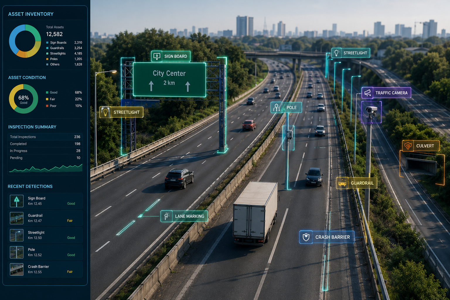
This is where road asset inventory management software is transforming the industry. AI-powered infrastructure management platforms are helping agencies move from reactive manual processes to intelligent, automated, and scalable operations.
Modern highways contain an enormous number of roadside assets that require regular monitoring and documentation. A single highway corridor may include:
As transportation infrastructure expands, the number of assets grows exponentially. Keeping track of these assets manually becomes inefficient, inaccurate, and expensive.
Traditional methods depend heavily on human inspections and handwritten observations. Teams travel long distances, capture photos, write notes, and later upload data into disconnected systems. This process introduces delays, inconsistencies, and missing information.
The result is incomplete infrastructure visibility.
Highway inspections require field teams to physically travel across large networks. Surveyors often stop repeatedly to record signboards, poles, barriers, or damaged assets.
For large transportation departments managing thousands of kilometers, completing a full inventory survey can take months.
During that time:
By the time the inventory is completed, much of the collected data is already outdated.
This is why agencies are shifting toward automated infrastructure survey systems powered by AI and computer vision.
Manual inventory collection depends heavily on individual inspectors.
Different surveyors may:
Even highly experienced field teams cannot maintain perfect consistency across thousands of assets.
This creates major problems for:
Modern AI-based infrastructure asset management platforms eliminate much of this inconsistency through automated detection and standardized digital workflows.
Many road agencies still rely on spreadsheets for infrastructure records.
However, spreadsheets fail when handling:
As infrastructure networks grow, spreadsheet-based systems become fragmented and difficult to maintain.
This is driving adoption of centralized digital asset inventory systems that integrate GIS mapping, AI detection, analytics, and inspection history into a unified platform.
Traditional inspections require:
For nationwide highway authorities, recurring inspections become extremely expensive.
AI-driven highway asset inventory automation reduces these operational costs significantly by automating data capture using:
Automated workflows reduce dependency on large field teams while increasing survey frequency.
Manual roadside inspections expose surveyors to moving traffic, difficult terrain, poor weather, and nighttime visibility challenges.
High-speed highways are particularly dangerous for field personnel conducting inventory audits.
AI-powered roadside asset inventory software enables remote inspections using video-based surveys and drone imagery, minimizing human exposure to hazardous conditions.
Transportation agencies worldwide are now adopting AI-enabled systems to modernize infrastructure management.
Modern platforms use:
These technologies automate the identification and classification of roadside assets at scale.
AI systems collect roadway data through:
This enables rapid large-scale surveys without stopping traffic or interrupting highway operations.
Advanced computer vision models identify:
This enables accurate AI roadside infrastructure detection across entire road corridors.
Detected assets are automatically geotagged and mapped into GIS systems.
This creates a centralized digital infrastructure database that supports:
Modern GIS road asset management systems provide highway authorities with real-time visibility into network conditions.
AI systems can inspect hundreds of kilometers daily, dramatically reducing survey timelines.
This enables:
Automated detection improves:
AI reduces human subjectivity and improves infrastructure reliability.
Accurate inventory data helps agencies:
This supports better road asset lifecycle management across transportation networks.
Transportation agencies face strict regulatory requirements for infrastructure documentation and safety audits.
AI-powered infrastructure compliance tracking helps maintain updated digital records that simplify reporting and inspections.
Modern transportation systems increasingly integrate with smart city infrastructure.
AI-powered smart road asset tracking supports:
Static annual inspections are no longer sufficient for modern road networks.
Infrastructure conditions change rapidly due to:
Agencies now require continuous infrastructure intelligence.
This is where AI highway infrastructure analytics becomes essential. Real-time monitoring allows road authorities to identify risks before they become major operational or safety issues.
The future of transportation infrastructure is autonomous, predictive, and data-driven.
Emerging technologies include:
As governments invest in smarter infrastructure, manual inspection systems will continue to decline.
Although AI-powered infrastructure management offers enormous benefits, agencies still face implementation challenges such as:
However, the long-term efficiency gains significantly outweigh the transition costs.
Successful agencies begin with pilot corridors and gradually scale across entire highway networks.
Manual highway asset inventory methods are no longer capable of supporting modern transportation infrastructure. Increasing road complexity, expanding asset networks, rising maintenance costs, and growing safety demands require a smarter approach.
AI-driven road asset inventory management software is helping transportation agencies transition from reactive inspections to intelligent infrastructure management. Through automation, computer vision, GIS mapping, and real-time analytics, agencies can improve operational efficiency, increase data accuracy, reduce costs, and strengthen roadway safety.
This transformation is already reshaping how highways are monitored and maintained globally.
RoadVision AI is helping infrastructure agencies, road authorities, and private contractors modernize roadway inspections through AI-powered surveys, automated asset detection, GIS-based infrastructure mapping, and intelligent highway analytics.
From dashcam surveys and drone inspections to AI-powered roadside asset recognition and digital infrastructure intelligence, RoadVision AI enables organizations to build scalable, future-ready highway operations.
If your organization is still dependent on spreadsheets, manual audits, or fragmented asset records, now is the time to move toward automated infrastructure intelligence.
Book a demo with RoadVision AI to explore how AI-powered highway asset management can transform your road operations.

The Autonomous Road Engineer
AI that is transforming road infrastructure, from reactive to predictive.
.webp)
.webp)
.png)