AI Pothole Detection: How Artificial Intelligence Is Fixing Our Roads
On this page
Potholes are one of the most universal frustrations of driving. They damage tires, bend rims, misalign suspensions, and in more serious cases, cause accidents. Every year, governments spend billions of dollars repairing roads and settling vehicle damage claims caused by potholes. Yet, despite the scale of the problem, most cities still rely on citizen complaints or occasional manual inspections to find and fix them.
This is changing rapidly thanks to AI pothole detectiontechnology. By combining computer vision, sensor data, and machine learning, AI-powered systems can now detect potholes automatically, accurately, and in real time transforming how road authorities identify and prioritize repairs. In this blog, we'll break down how AI pothole detection works, the technology behind it, its real-world applications, and what the future holds.
What Is AI Pothole Detection?
AI pothole detection refers to the use of artificial intelligence specifically computer vision and machine learning models to automatically identify potholes on road surfaces using images, video, or sensor data. Instead of relying on manual road surveys or citizen-reported complaints, AI road monitoring systems can scan roads continuously through cameras mounted on vehicles, drones, or even smartphones, flagging potholes the moment they're detected.
These systems don't just detect the presence of a pothole they can also estimate its size, depth, and severity, and pinpoint its exact GPS location for maintenance crews to act on.
Why Traditional Pothole Detection Falls Short
Before AI, pothole detection relied heavily on:
Citizen Complaints: Many cities depend on residents calling in or submitting online reports, which means potholes often go unnoticed until they've already caused damage or accidents.
Manual Road Surveys: Engineers physically drive or walk along roads to spot defects a slow, expensive, and inconsistent process.
Reactive Repair Cycles: Without early detection, potholes are usually fixed only after they've grown large enough to be dangerous or noticeable.
Limited Coverage: Rural roads and low-traffic streets are often overlooked simply because there aren't enough inspectors to cover every mile.
These limitations mean that many potholes remain unaddressed for weeks or months, worsening over time and increasing repair costs and safety risks.
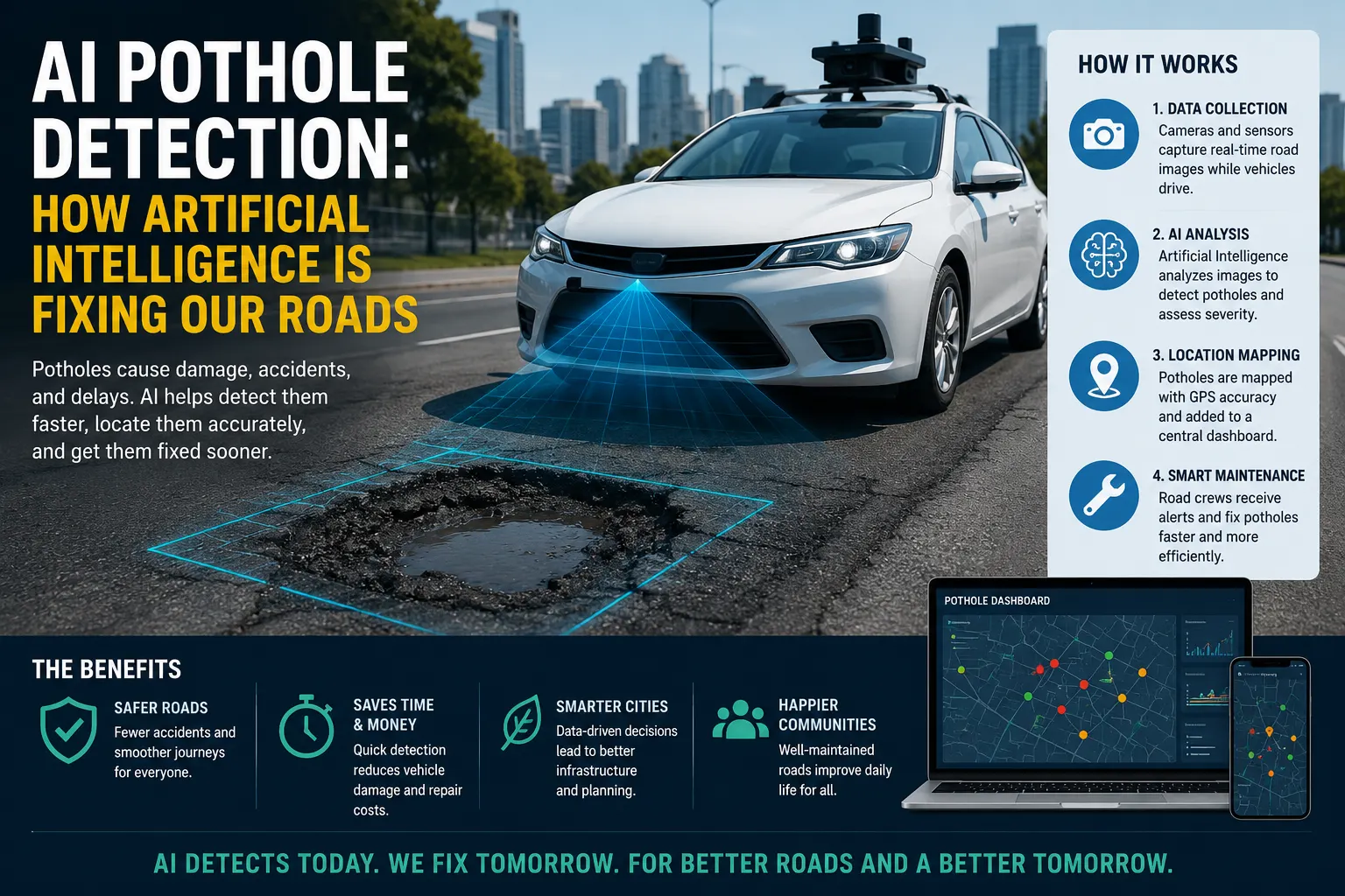
How AI Pothole Detection Works
AI pothole detection systems typically follow a structured pipeline, combining hardware and software to identify and classify road defects.
1. Data Capture
The process begins with data collection. This is done using:
Dashcams or mounted cameras on municipal vehicles, buses, or ride-share fleets
Smartphone cameras and sensors in citizen-reporting apps
Drone footage for aerial inspection of large or hard-to-reach areas
LiDAR and accelerometer sensors that detect vibrations and surface irregularities as a vehicle passes over a pothole
2. Computer Vision and Image Processing
Once images or video are captured, AI models typically convolutional neural networks (CNNs) or more advanced object detection architectures like YOLO (You Only Look Once) or Faster R-CNN analyze the visual data frame by frame. These models are trained on thousands of labeled images of potholes in various lighting, weather, and road conditions, allowing them to distinguish potholes from shadows, manholes, or surface stains with high accuracy.
3. Sensor Fusion for Validation
To reduce false positives, many systems combine visual detection with accelerometer and gyroscope data. When a vehicle's suspension reacts to a bump or dip, the system cross-references this vibration data with the image analysis, confirming whether the anomaly is genuinely a pothole rather than a shadow or debris.
4. Severity and Size Estimation
Advanced AI pothole detection systems go beyond simple identification they estimate the pothole's depth, diameter, and structural risk. This allows maintenance teams to prioritize larger, more dangerous potholes over minor surface imperfections.
5. Geotagging and Reporting
Every detected pothole is tagged with precise GPS coordinates and timestamped. This data is automatically uploaded to a centralized dashboard, where city planners and maintenance crews can view a live map of pothole locations, sorted by severity and urgency.
6. Automated Alerts and Work Orders
In more advanced deployments, AI pothole detection systems integrate directly with municipal work order software, automatically generating repair tickets and dispatching crews without requiring manual data entry.
Key Technologies Behind AI Pothole Detection
Convolutional Neural Networks (CNNs): The backbone of most image-based pothole detection models, capable of learning visual patterns associated with road damage.
Object Detection Frameworks: Models like YOLO, SSD, and Faster R-CNN allow real-time detection of potholes within video streams.
Edge Computing: Many systems process data directly on-device (in the vehicle or camera unit) to reduce latency and bandwidth usage before sending results to the cloud.
Cloud-Based Analytics: Centralized platforms aggregate data from multiple vehicles or sensors across a city, creating a comprehensive, continuously updated pothole map.
GPS and GIS Integration: Ensures every detected pothole is accurately mapped for maintenance planning and historical tracking.
Benefits of AI Pothole Detection
For City and Road Authorities
Faster Detection: Potholes are identified within hours or days of forming, rather than weeks or months.
Cost Efficiency: Early repairs are significantly cheaper than fixing large, deteriorated potholes or paying out damage claims.
Data-Driven Prioritization: Maintenance crews can focus on high-severity, high-traffic potholes first, optimizing limited budgets and resources.
Reduced Liability: Documented, timestamped detection data can help cities demonstrate proactive maintenance efforts in legal disputes.
For Drivers and Commuters
Improved Safety: Faster repairs mean fewer accidents, tire blowouts, and vehicle damage.
Real-Time Navigation Alerts: Some systems integrate with GPS navigation apps to warn drivers of upcoming potholes, allowing them to avoid or slow down in time.
Smoother Rides: Well-maintained roads reduce wear and tear on vehicles and improve overall driving comfort.
For the Environment
Reduced Fuel Consumption: Smoother roads mean less energy wasted on vehicles jolting over damaged surfaces.
Extended Road Lifespan: Early pothole repair prevents further surface degradation, reducing the need for full road reconstruction.
Real-World Applications of AI Pothole Detection
Municipal Fleet Integration: Many cities are equipping garbage trucks, buses, and police vehicles with dashcams to passively collect pothole data during their normal routes.
Citizen Reporting Apps: Some platforms allow residents to snap a photo of a pothole, which AI then verifies, classifies, and logs automatically.
Ride-Share and Delivery Fleets: Companies with large vehicle fleets are exploring crowdsourced pothole detection using existing dashcams, creating dense, real-time road condition data at scale.
Highway Authority Inspections: National and regional highway agencies use AI-equipped inspection vehicles to survey thousands of miles of road far faster than manual crews ever could.
Drone-Based Surveys: For remote or hard-to-access roads, drones equipped with high-resolution cameras and AI models can identify potholes without requiring ground vehicles.
Challenges in AI Pothole Detection
Despite its promise, AI pothole detection technology faces a few hurdles:
Weather and Lighting Variability: Rain, snow, shadows, and low-light conditions can affect detection accuracy if models aren't trained on diverse datasets.
False Positives: Manholes, patched repairs, or surface stains can sometimes be misclassified as potholes without proper sensor fusion and validation.
Data Privacy Concerns: Continuous video and location data collection from vehicles requires careful data governance and anonymization.
Infrastructure Costs: Initial investment in cameras, sensors, and AI processing infrastructure can be a barrier for smaller municipalities.
Integration with Legacy Systems: Connecting new AI detection platforms with older municipal asset management software can require additional development work.
The Future of AI Pothole Detection
As AI models improve and hardware costs decline, pothole detection technology is expected to become even more precise and widely adopted. Emerging trends include:
Crowdsourced Detection at Scale: Leveraging smartphones and consumer vehicle dashcams to build dense, real-time pothole maps without dedicated inspection fleets.
Integration with Autonomous Vehicles: Self-driving cars will both detect and avoid potholes in real time, feeding data back into shared infrastructure maps.
Predictive Pothole Formation: AI models may soon predict where potholes are likely to form based on traffic load, weather patterns, and road material aging—before they even appear.
AI pothole detection is transforming road maintenance from a reactive, complaint-driven process into a proactive, data-driven system. By leveraging computer vision, sensor fusion, and real-time analytics, cities and highway authorities can detect potholes faster, prioritize repairs more effectively, and ultimately create safer roads for everyone. While challenges around cost, accuracy, and integration remain, the long-term benefits reduced repair costs, improved safety, and smarter infrastructure planning make AI pothole detection one of the most impactful applications of artificial intelligence in modern urban infrastructure.
Frequently Asked Questions (FAQs)
1. What is AI pothole detection?
AI pothole detection is the use of artificial intelligence, particularly computer vision and machine learning, to automatically identify, classify, and locate potholes on road surfaces using cameras, sensors, and GPS data.
2. How accurate is AI in detecting potholes?
Modern AI pothole detection models can achieve accuracy rates above 90% under good conditions, though performance can vary based on lighting, weather, and the quality of training data.
3. What technology is used for AI pothole detection?
Common technologies include convolutional neural networks (CNNs), object detection frameworks like YOLO, accelerometer and LiDAR sensors, GPS geotagging, and cloud-based analytics platforms.
4. Can smartphones be used for AI pothole detection?Y
es. Many citizen-reporting apps and crowdsourced platforms use smartphone cameras and accelerometers to detect and report potholes, which AI then verifies and classifies.
5. How does AI pothole detection help reduce repair costs?
By identifying potholes early, before they grow larger and more expensive to fix, AI detection enables proactive maintenance instead of costly emergency repairs.




.webp)
.webp)
.webp)