Rajamahendravaram — known widely as Rajahmundry — is one of Andhra Pradesh's oldest and most culturally significant cities, and an expanding urban centre whose road network must support growing commerce, daily commuter movement, and increasingly heavy freight traffic. The Rajamahendravaram Municipal Corporation (RMC) carried responsibility for this network, but the methods it relied on were not keeping pace with the city's growth.
Traditional road inspections were slow, labour-intensive, and hostage to human inconsistency. Field teams could assess only what they could see, log only what they could record manually, and produce reports that offered no reliable basis for year-on-year comparison. Defects were identified reactively — after deterioration had already become visible to residents or caused safety incidents. Without an automated pavement condition monitoring system, every budget decision was a controlled guess.
Without a consistent, GPS-tagged condition score per road segment, there was no way to determine whether the network was improving or deteriorating — making defensible budget requests to state finance departments effectively impossible.
Distress identification was driven by complaints, not evidence. By the time a pothole or structural failure was formally logged, it had already progressed from a preventive treatment opportunity into an expensive intervention requirement.
With no pre-repair condition record, contractors faced no objective standard for work quality. There was no before/after comparison, no AI road safety audit trail, and no mechanism to make payment certification data-driven.
When personnel changed, road history moved with them. There was no digital road register, no corridor-level distress inventory, and no platform preserving institutional knowledge across administrative transitions.

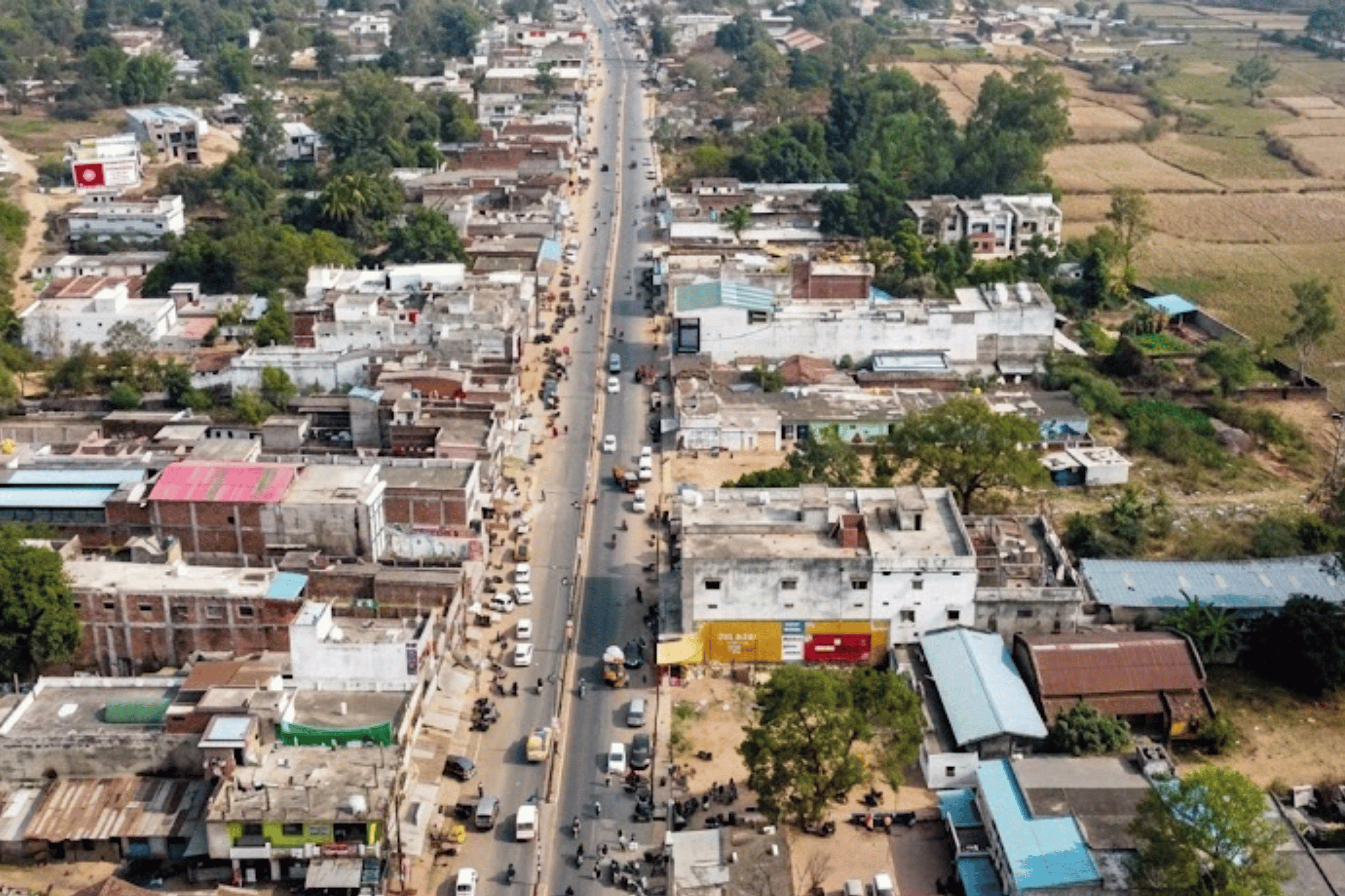
RMC and RoadVision AI partnered to conduct a pilot covering 100 kilometres of Rajamahendravaram's road network — one of the larger single-city pilot deployments in RoadVision AI's India programme. The objective: demonstrate AI pavement inspection at meaningful scale, generate actionable outputs for RMC's engineering teams, and build the foundation for city-wide continuous monitoring using a smart city road safety solution.
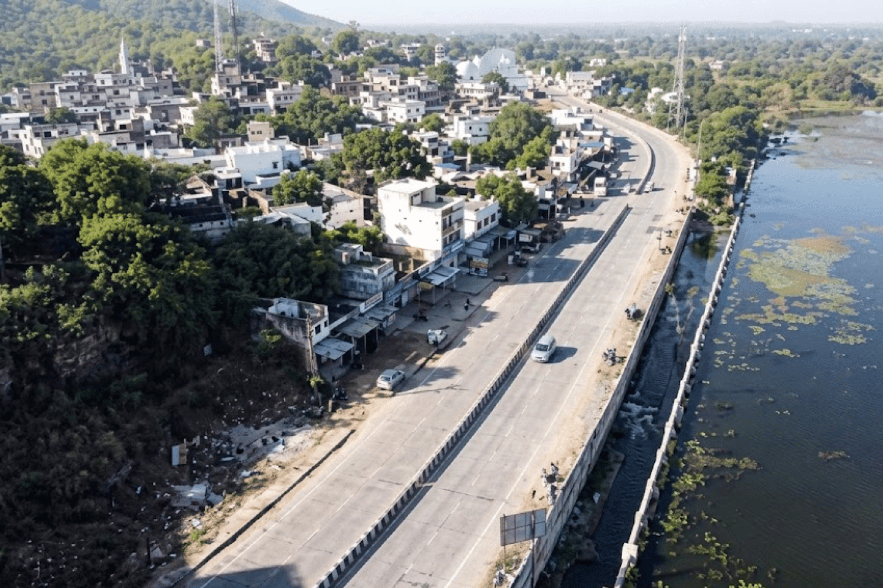
Data was collected using the RoadVision AI mobile app mounted on survey vehicles via a standard suction windshield device. Vehicles drove Rajamahendravaram's roads at regular traffic speed — capturing continuous high-resolution video, images, and GPS coordinates across all 100 kilometres without lane closures, specialist equipment, or any disruption to daily movement. This approach fundamentally reframes the cost and complexity of pavement analysis software deployment.
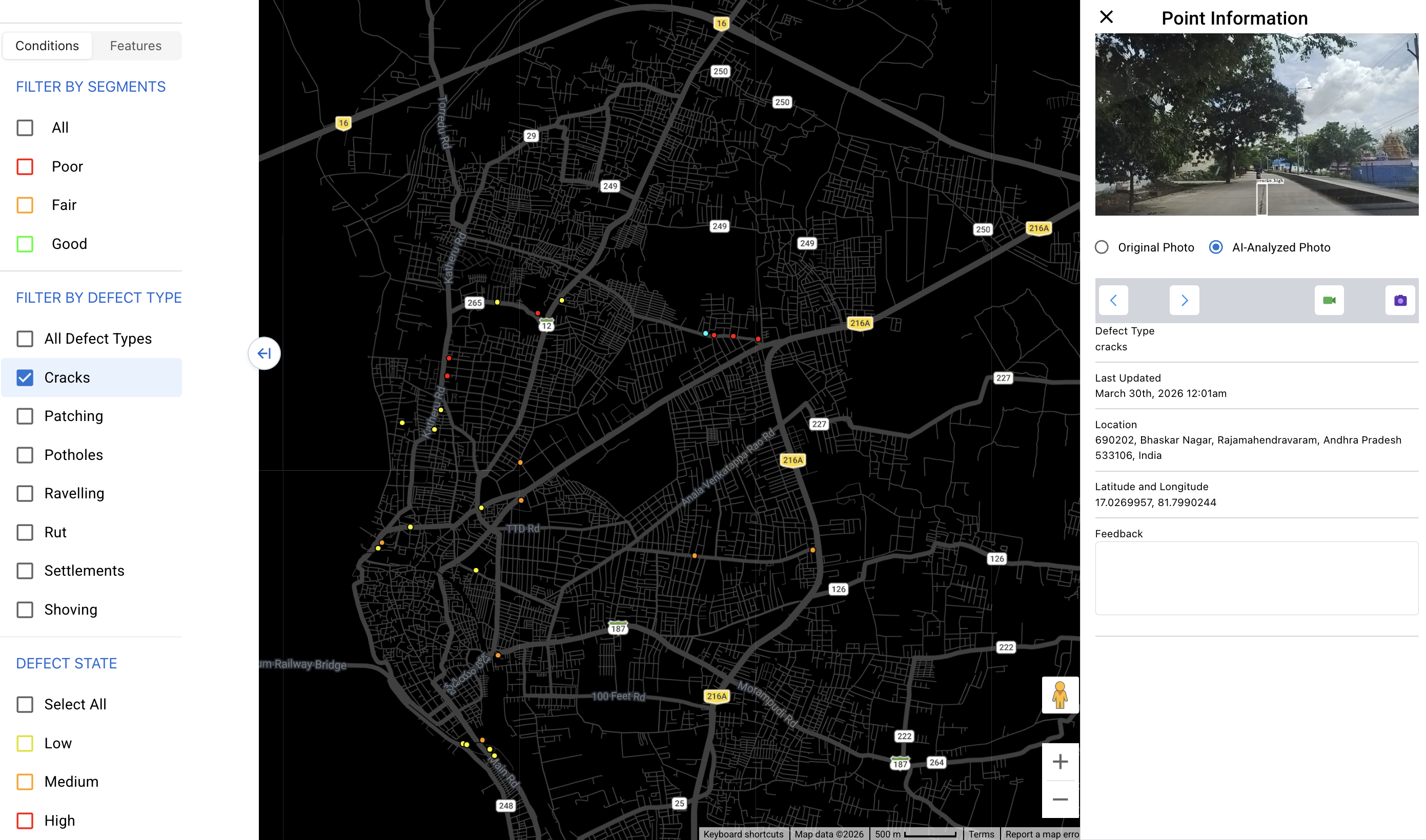
Footage was processed through RoadVision AI's intelligence platform, which automatically identified and classified road conditions and distress types — ravelling, rutting, cracking, potholes, shoving, and settlements — in line with IRC guidelines. This automated pavement distress detection engine computed pavement distress ratings for every 100-metre segment, assessed road signage compliance, and geotagged every defect to a precise GPS coordinate. No human annotation was required.
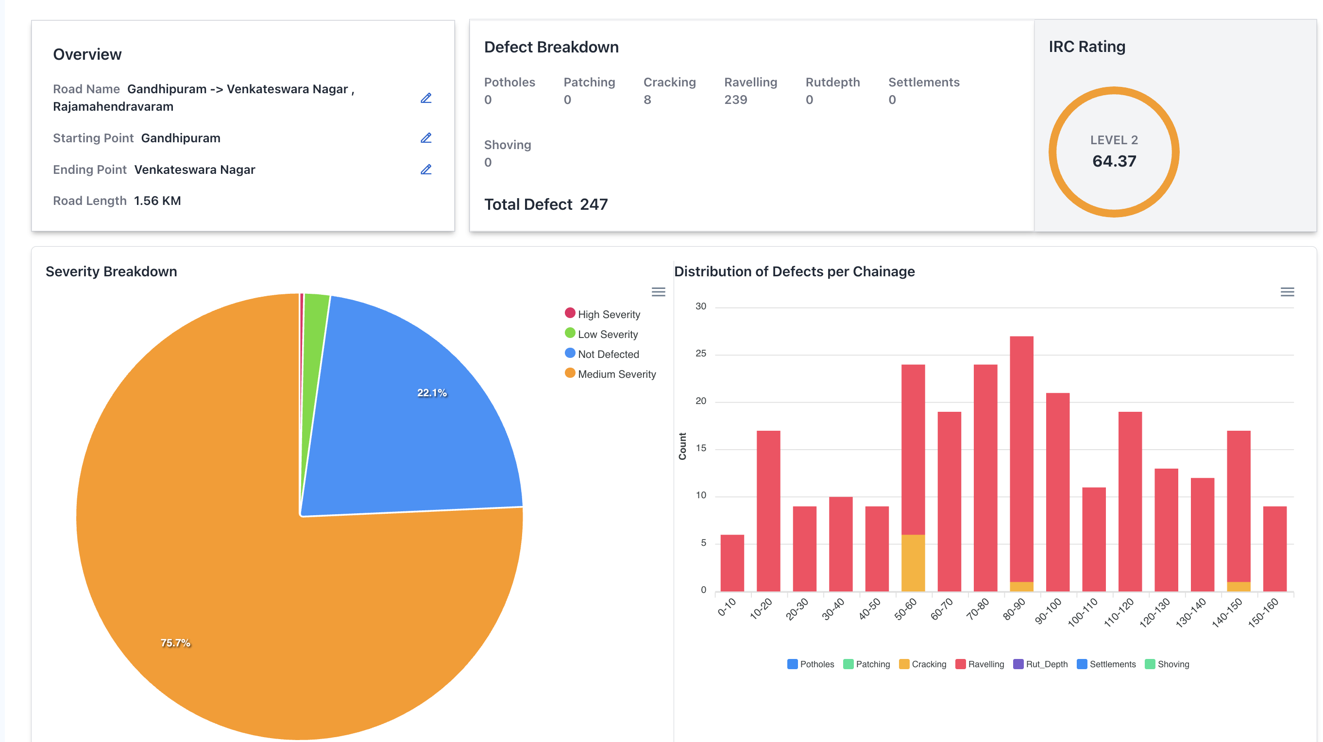
RMC received AI-generated condition reports in IRC-compliant formats, a live GIS platform with colour-coded road segmentation by condition severity, and a comprehensive road signage inventory flagging compliant and missing signs. Three key corridors — Jawaharlal Nehru Road, Korukonda Road, and Gandhipuram — received detailed, corridor-level assessments with specific intervention recommendations, forming the nucleus of RMC's new road asset management system.

Unlike a conventional inspection report, RoadVision AI's deployment delivers a complete operational infrastructure — five interlocking outputs that together constitute a living road asset management system for the city.
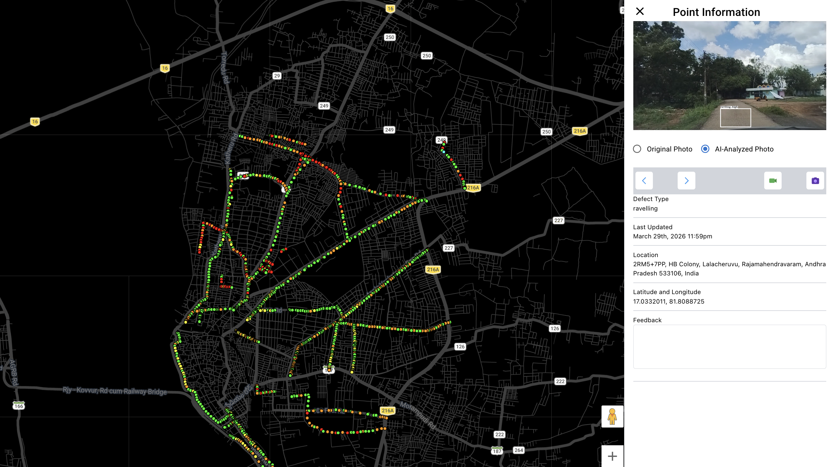
Every metre of every road surveyed is preserved as video — both the original dashcam footage and an AI-processed version with detected defects marked in real time. This is the evidentiary backbone of the AI pavement inspection system: a permanent, GPS-timestamped visual archive that never expires and supports dispute resolution, planning review, and contractor accountability for years after the initial survey.

Every surveyed road receives a permanent, structured record — a Road Register with a standardised IRC PCI score that forms the backbone of evidence-based maintenance planning. This automated pavement distress detection output calculates scores per 100-metre chainage segment from 0 (complete failure) to 100 (perfect condition), removing subjectivity from the process and enabling defensible year-on-year comparison.
Results are published simultaneously to a web-based GIS platform accessible to all authorised RMC engineering personnel. The digital safety audit platform provides a colour-coded road network map (green/amber/red by condition severity), filterable defect markers, and segment-level drill-down — enabling engineering teams to generate data-driven work orders directly from the dashboard without manual preparation.
Beyond pavement condition, the AI road safety audit module captured the full safety asset inventory across all 100 kilometres — flagging compliant signs, missing signs, faded road markings, damaged crash barriers, and missing road studs. This is the autonomous road safety audit layer of the deployment: a comprehensive, GPS-tagged compliance record that gives RMC an evidence base for targeted safety interventions without conducting a separate inspection exercise.
The AI road condition analysis platform delivers four nested levels of analytics that support every tier of the municipal decision-making chain — from engineer to department head to elected body. This is the layer that converts raw AI detections into the strategic intelligence a road asset management system must provide.
The AI based pavement condition monitoring system revealed a road network carrying the full spectrum of urban distress — from surface-level ravelling pointing to widespread coating deterioration, to structural failures like rutting and settlements demanding investigation below the pavement layer. No corridor returned a clean bill of health. Every stretch now has an IRC score and a mapped defect inventory.
The three priority corridors assessed — Jawaharlal Nehru Road, Korukonda Road, and Gandhipuram — are among the city's most economically and socially significant. Their corridor-level assessments gave RMC, for the first time, a precise picture of where to act, in what order, and with what intervention type — moving from complaint-driven reaction to data-driven prioritisation.
"For the first time, RMC has a corridor-by-corridor picture of its road network — not a visual impression, but a verified, GPS-tagged, IRC-scored inventory of every defect across 100 kilometres."

The pilot delivered more than a snapshot. It gave RMC a new operational capability — the ability to manage infrastructure on evidence rather than estimation. That shift, from reactive to proactive, from subjective to standardised, is what the outcomes below reflect.
IRC PCI scores are an objective foundation for maintenance budget requests — far more persuasive when presenting to elected bodies or state finance departments than field observations and complaint logs. The pavement analysis software output directly supports tier-1 governance decisions.
Engineers can generate repair work orders directly from the defect list — with GPS coordinates, defect types, severity, and priority ranking already computed by the AI road condition analysis engine. No guesswork, no manual preparation, no subjective prioritisation.
Pre- and post-repair surveys create a timestamped, GPS-verified baseline before any intervention and an independent condition measurement after. This digital safety audit platform layer makes quality-based payment certification objectively possible for the first time.
The Road ID system means every survey builds on the last. When personnel change, the full history of every road — every IRC score, every repair record, every deterioration event — remains in the platform, intact and searchable as part of the road asset management system.
5. Predictive, Not Reactive
As the temporal database accumulates across survey cycles, the AI based pavement condition monitoring system identifies deterioration curves — flagging roads heading toward failure before they fail. Preventive treatment costs a fraction of emergency reconstruction.
6. A Replicable Blueprint for Andhra Pradesh
Rajamahendravaram's deployment demonstrates a model that scales to any urban body in India — ULB, municipal corporation, PWD, or NHAI. The methodology, the smart city road safety solution architecture, and the deliverable structure are consistent regardless of network size.
Field data collection for 100 KM of urban roads takes 5–7 days using smartphone-equipped survey vehicles driven at normal traffic speed — no lane closures or specialist mobilisation required. AI processing of the complete footage through the automated pavement distress detection engine takes approximately 2 hours after upload. A full formal IRC-compliant report is delivered within 4–6 weeks of data collection completion.
Manual inspection is subjective, non-comparable across inspectors, and produces outputs that cannot serve as a legal or contractual baseline. The AI pavement inspection approach delivers standardised IRC scores per 100m segment, GPS-tagged defect coordinates, video evidence for every finding, and year-on-year comparability — none of which manual inspection can match. The pavement analysis software also covers 100 KM in the time it would take a manual team to assess a fraction of that network.
Yes — this is one of the highest-value applications for Municipal Corporations. By conducting pre- and post-repair surveys, departments get a timestamped, GPS-verified baseline before any intervention and an independent condition measurement after. This digital safety audit platform layer creates a structural accountability trail that cannot be disputed, and makes quality-based payment certification objectively possible for the first time. The road asset management system holds this trail permanently.
RoadVision AI detects 35+ parameters across five categories: pavement defects (potholes, ravelling, rutting, cracking, shoving, settlements), kerb and median conditions, drainage structure health, road safety features (signage, markings, crash barriers, road studs), and governance issues (encroachments, cleanliness, asset change detection). All parameters are captured in a single survey pass. The AI road safety audit module flags every non-compliant safety asset with GPS coordinates and severity classification.
Every road surveyed is assigned a persistent unique Road ID in the platform. All future surveys — monthly, seasonal, post-monsoon, or post-repair — automatically map to the same IDs, building a cumulative temporal database. This enables the AI based pavement condition monitoring system to forecast deterioration curves, measure maintenance effectiveness through before/after PCI comparisons, and optimise budget allocation based on predicted condition trajectories rather than complaint patterns. It is the core of any sustainable smart city road safety solution.
The complete output includes: (1) a video library with raw and AI-annotated footage for every road; (2) a Road Register with IRC PCI scores per road and per 100m chainage segment; (3) a live GIS dashboard with colour-coded condition map and filterable defect markers — the digital safety audit platform layer; (4) structured analytics at defect, chainage, road, and network levels; and (5) a road safety asset inventory with GPS-tagged compliance records for signage, markings, and safety features. All outputs are available in PDF, Excel, and the live platform.
From survey design to live GIS platform — RoadVision AI delivers the full road asset management system, not just a report. Book a demo to see how Rajamahendravaram's deployment model applies to your city.

The Autonomous Road Engineer
AI that is transforming road infrastructure, from reactive to predictive.
%20(1).png)