Saudi Arabia is undertaking one of the world's most ambitious infrastructure transformations. Under Saudi Vision 2030, the Kingdom is investing heavily in highways, smart cities, logistics corridors, and transportation networks to support economic diversification and future growth.
With more than 200,000 kilometres of highways and municipal roads connecting industrial zones, urban centres, ports, and mega-projects such as NEOM, maintaining road quality has become a national priority.
However, extreme temperatures, heavy freight movement, and desert conditions create unique challenges for pavement performance. Traditional manual inspections are often time-consuming, expensive, and unable to provide the continuous visibility required across such a vast network.
As the saying goes, "You can't manage what you can't measure."
This is why AI pavement survey Saudi Arabia solutions are rapidly becoming essential for modern road asset management. By combining computer vision, machine learning, and real-time analytics, platforms like RoadVision AI enable authorities to inspect road networks faster, more accurately, and at a significantly lower cost.
Road networks across the Kingdom face several environmental and operational pressures:
Traditional survey methods often struggle to keep pace with these challenges.
Modern automated road condition assessment KSA solutions enable transportation authorities to move from reactive repairs to proactive maintenance by providing:
Instead of waiting for failures to appear, agencies can intervene earlier and extend pavement service life.
Effective pavement management must comply with Saudi engineering requirements and inspection frameworks.
RoadVision AI supports compliance with:
These frameworks require consistent documentation of:
By integrating AI into inspections, authorities can generate standardised, auditable, and repeatable assessments across entire road networks.
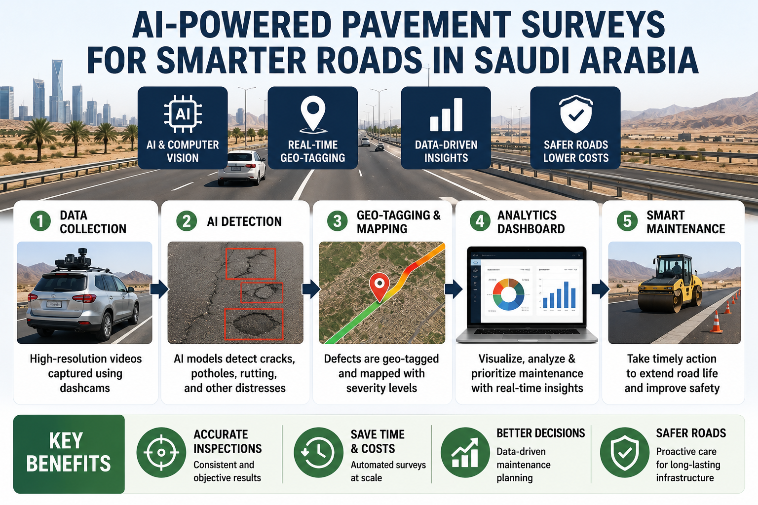
Vehicle-mounted cameras continuously capture roadway imagery during normal operations.
This approach allows authorities to conduct dashcam AI road survey KSA programmes without:
Road condition data can be collected using existing municipal, maintenance, or fleet vehicles.
Advanced computer vision models automatically identify pavement distress.
Modern AI-powered road distress detection Saudi Arabia systems can detect:
Each defect is classified according to severity levels, helping engineers prioritise maintenance activities more effectively.
Road deterioration often begins with small surface cracks that are difficult to identify through manual inspections.
Using deep learning road crack detection Saudi technologies, AI systems can identify early-stage distress before significant structural damage occurs.
Benefits include:
Detecting small defects before they become major failures supports long-term asset preservation.
Every detected defect is automatically geotagged and mapped.
Modern pavement condition index AI Saudi Arabia platforms provide:
Engineers can instantly visualise network conditions and identify priority repair zones.
One of the biggest advantages of AI is its ability to support preventive maintenance strategies.
Rather than waiting for roads to deteriorate significantly, proactive road maintenance AI Saudi Arabia solutions enable agencies to:
This shift from reactive to predictive maintenance significantly lowers long-term infrastructure costs.
Saudi Arabia's infrastructure strategy requires smart, connected, and resilient transportation networks.
Modern AI infrastructure management Vision 2030 roads initiatives support these objectives by providing:
As smart mobility projects continue to expand, AI-based pavement intelligence will become increasingly important for maintaining transportation reliability.
Summer temperatures regularly exceed 45°C in many regions, accelerating pavement ageing and material degradation.
AI systems continuously monitor surface conditions, helping agencies identify temperature-related deterioration before it escalates.
Desert environments can cause surface abrasion and reduce pavement visibility.
Advanced machine learning algorithms can distinguish between temporary surface contamination and actual pavement defects, improving inspection accuracy.
Thousands of kilometres of roads pass through remote desert areas.
AI-powered surveys enable continuous monitoring without requiring large field teams to travel long distances.
Freight corridors experience significant loading stress.
Continuous monitoring helps engineers identify high-risk sections and prioritise maintenance investments accordingly.
RoadVision AI combines advanced computer vision with scalable infrastructure analytics to deliver:
The platform enables transportation agencies, consultants, municipalities, and infrastructure operators to make faster and more informed maintenance decisions.
Saudi Arabia's expanding transportation network requires smarter approaches to pavement management. Traditional inspection methods alone can no longer provide the speed, consistency, and scale required to support modern infrastructure demands.
Through automated road condition assessment KSA and intelligent asset management platforms, road authorities can detect problems earlier, optimise maintenance budgets, and improve network performance.
As the Kingdom advances toward its Vision 2030 goals, AI-driven pavement intelligence will play a critical role in building safer, more resilient, and future-ready roads.
After all, a small defect detected today can prevent a major failure tomorrow.
Ready to modernise your pavement inspection programme?
Book a demo with RoadVision AI to discover how AI-powered pavement surveys, pothole detection, and predictive maintenance can help your organisation improve road quality, reduce costs, and support Saudi Arabia's next generation of smart infrastructure.
AI systems analyse road imagery captured by vehicle-mounted cameras using deep learning models. These models automatically identify potholes, cracks, rutting, ravelling, and other pavement defects while recording their severity and GPS location.
AI surveys provide faster network coverage, more consistent results, automated reporting, reduced inspection costs, and continuous monitoring without disrupting traffic operations.
AI improves road asset management by enabling proactive maintenance, real-time condition monitoring, data-driven decision-making, and smarter infrastructure planning—helping authorities build safer and more sustainable transportation networks.

The Autonomous Road Engineer
AI that is transforming road infrastructure, from reactive to predictive.
.webp)
.webp)
.png)