In modern highway engineering, the functional performance of a road is ultimately judged by how it behaves under real traffic conditions. One of the most reliable and globally accepted indicators of this performance is the International Roughness Index (IRI). It serves as a standardized measure of road surface irregularities and plays a critical role in determining ride quality, safety, and long-term pavement sustainability.
For civil engineers and government authorities, IRI is not just a technical metric—it is a decision-making foundation. It directly influences maintenance planning, contract evaluation, and network-level performance monitoring. However, while global standards define threshold values for acceptable roughness, the real challenge lies in consistent and scalable measurement across large road networks. This is where AI-based road inspection is transforming traditional practices.

The International Roughness Index (IRI) is calculated based on the response of a standardized vehicle model traveling over a road surface. It measures cumulative vertical deviations in the longitudinal profile and expresses them in meters per kilometer.
From a civil engineering standpoint, IRI reflects:
Unlike visual inspections, IRI provides a quantifiable and objective measure of road condition. Even minor undulations that are not easily visible can significantly affect ride quality and are captured through IRI measurements.
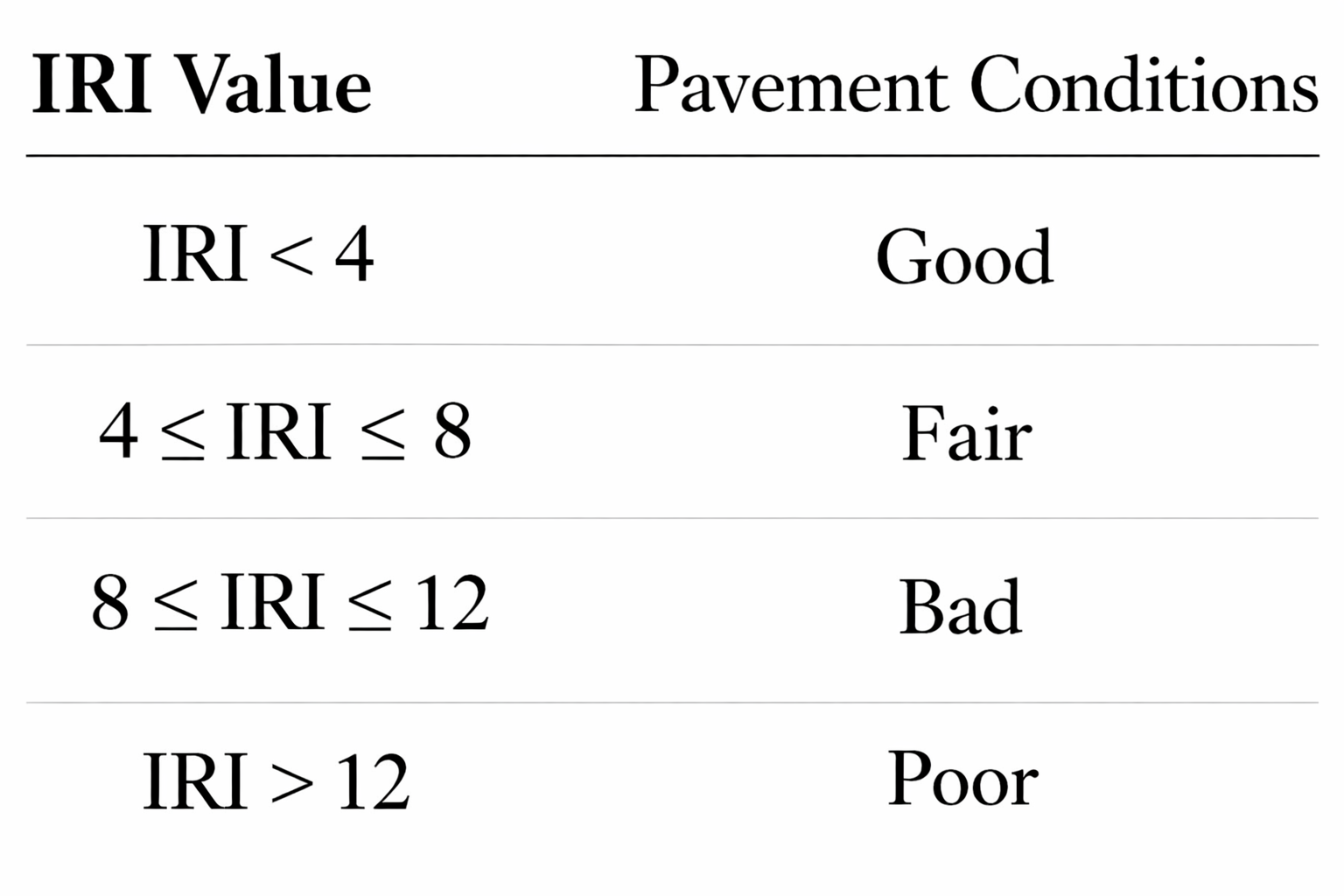
Global highway agencies use IRI thresholds to classify pavement condition into performance categories. These thresholds are designed based on the relationship between road roughness and its impact on users and infrastructure systems.
For engineers and authorities, these thresholds are applied in three critical ways.
First, they act as maintenance intervention triggers. When IRI values cross predefined limits, it indicates that the pavement has moved from acceptable condition to a stage where corrective action is required. This prevents further deterioration and avoids higher rehabilitation costs.
Second, IRI is used in performance-based evaluation frameworks. Contractors are often required to deliver roads within specific roughness limits. This ensures construction quality and accountability throughout the project lifecycle.
Third, IRI enables network-level prioritization. Government agencies managing extensive road networks rely on IRI data to identify which stretches require immediate attention and which can be scheduled for future maintenance. This approach is essential for implementing predictive road maintenance strategies.
Traditional IRI measurement methods, while accurate, present several operational challenges when applied at scale.
These methods depend on specialized equipment such as profilometers and inertial systems, which require significant investment and skilled operation. As a result, data collection is often limited to specific project phases or selected road sections.
Another major limitation is the low frequency of surveys. Since these measurements are costly and time-consuming, they are conducted periodically rather than continuously. This creates gaps in understanding how road conditions evolve between survey cycles.
For large-scale highway networks, especially under government authorities, this leads to delayed decision-making and inefficient resource allocation. Critical deterioration phases may go unnoticed until they reach advanced stages.
The emergence of AI-based road inspection and automated road condition assessment systems is addressing these challenges by enabling continuous, scalable, and cost-effective roughness measurement.
Instead of relying solely on dedicated survey vehicles, modern systems utilize:
These systems estimate International Roughness Index (IRI) values by analyzing both visual surface characteristics and vehicle response patterns.
AI-driven systems rely on a combination of sensing and computation to derive meaningful roughness indicators.
Using computer vision for road inspection, the system analyzes surface textures, cracks, and undulations that contribute to roughness. At the same time, motion sensors capture vertical acceleration and vibration patterns as vehicles move over the road.
Machine learning models are trained to correlate these inputs with standard IRI values, enabling accurate estimation without traditional profilometers.
This approach allows engineers to move from episodic measurement to continuous monitoring, which is critical for modern infrastructure systems.
For civil engineers, the integration of AI into IRI measurement fundamentally changes how pavement performance is assessed.
Instead of relying on limited datasets, engineers gain access to continuous and high-resolution data. This allows for early detection of surface irregularities before they evolve into major structural failures.
It also improves the reliability of design validation. Post-construction IRI analysis can highlight whether construction practices have achieved the desired smoothness levels, enabling corrective action at an early stage.
Additionally, engineers can correlate IRI data with traffic loading and environmental conditions to better understand deterioration patterns, leading to more resilient pavement designs.
For government infrastructure bodies, the benefits extend beyond engineering into policy and planning.
With real-time road condition monitoring, authorities can maintain a dynamic view of network performance rather than relying on static reports. This allows for more responsive decision-making and better service delivery.
The ability to implement predictive road maintenance is particularly significant. Instead of reacting to failures, agencies can forecast deterioration trends and intervene at optimal stages, reducing lifecycle costs.
Furthermore, AI-enabled systems support centralized dashboards and integration with smart infrastructure platforms, strengthening overall road safety analytics capabilities.
Road roughness is directly linked to safety outcomes. Higher IRI values lead to:
Maintaining optimal IRI levels ensures smoother rides, better vehicle control, and improved safety for all users.
For authorities, this translates into fewer accidents, lower maintenance costs, and higher public satisfaction.
The fundamental shift brought by AI is the transition from periodic measurement to continuous intelligence.
Traditional systems provide snapshots of road conditions at specific points in time. In contrast, AI systems create a continuous data stream that reflects real-world conditions as they evolve.
This shift is essential for modern infrastructure systems that demand:
At RoadVision AI, we focus on transforming how road performance is measured and managed through intelligent systems.
By combining automated road inspection, digital road condition assessment, and advanced analytics, we enable infrastructure stakeholders to move beyond traditional limitations.
Our approach allows civil engineers and authorities to monitor International Roughness Index (IRI) continuously, identify risks early, and make informed decisions that improve both safety and efficiency.
The International Roughness Index (IRI) remains one of the most critical parameters in evaluating road performance. However, the way it is measured and utilized is evolving rapidly.
For civil engineers and government authorities, adopting modern, scalable approaches is no longer optional. The integration of AI into roughness measurement provides the accuracy, frequency, and intelligence required to manage today’s complex road networks.
Infrastructure performance is no longer defined by construction alone—it is defined by how effectively it is monitored and maintained over time.
If road agencies want to improve safety, optimize budgets, and extend pavement life, the starting point is clear: measure better, measure continuously.
RoadVision AI is enabling this shift by bringing intelligence into road condition monitoring.
Connect with us to explore how AI-driven road condition monitoring can transform your highway network into a smarter, more efficient system.
The International Roughness Index (IRI) is a globally accepted metric used to measure road surface roughness and ride quality. It evaluates the vertical irregularities of a pavement surface and is typically expressed in meters per kilometer (m/km). Civil engineers and highway authorities use IRI to assess pavement performance, prioritize maintenance, and monitor overall road condition.
AI-based road inspection systems use cameras, motion sensors, and machine learning algorithms to continuously estimate road roughness without relying only on expensive profilometers or specialized survey vehicles. By combining computer vision for road inspection with sensor-based vehicle response analysis, AI enables scalable, real-time, and cost-effective International Roughness Index (IRI) monitoring across large highway networks.
Continuous IRI monitoring helps authorities detect pavement deterioration early, implement predictive road maintenance strategies, improve ride quality, and reduce long-term rehabilitation costs. It also supports better road safety outcomes by identifying rough or damaged sections before they become major hazards, enabling more efficient infrastructure management and budget allocation.

The Autonomous Road Engineer
AI-powered road condition monitoring, asset management, & infrastructure intelligence helping agencies move from reactive maintenance to predictive road management.
.webp)
.webp)
.webp)