Road networks have grown faster than the systems built to manage them. Provincial highway authorities, municipal public works departments, concessionaires, and national road agencies are now responsible for road networks spanning tens of thousands of kilometres yet most still rely on inspection methods, reporting workflows, and decision-making processes designed for a fraction of that scale.
The result is a structural mismatch that every road authority recognizes, even if they have not named it precisely. Field crews can physically cover only a fraction of the network in a given inspection cycle. Condition data sits in siloed systems that never talk to each other. Engineering expertise is scarce relative to the size of the asset base that needs reviewing. Inspections happen quarterly or annually while pavement, signage, and safety conditions change daily. And because problems are caught late, a defect that could have been addressed for a few thousand dollars in preventive treatment becomes a six-figure emergency repair.
This is the problem RoadVision AI was built to solve. Rather than digitizing the old inspection process, RoadVision AI has built what it calls the Autonomous Road Engineer a platform of specialist AI agents that continuously collect, process, and act on road condition data across the full lifecycle of a road network, from design through construction to operations and maintenance. Today the platform has been deployed across more than 20,000 miles of road in 17 countries, working with road authorities, contractors, consultants, and investors who need network-wide visibility that manual processes simply cannot deliver.
This blog explains what an AI road monitoring system actually is, how RoadVision AI's platform works end to end, and why this category of technology is becoming essential infrastructure for anyone responsible for the roads people drive on every day.
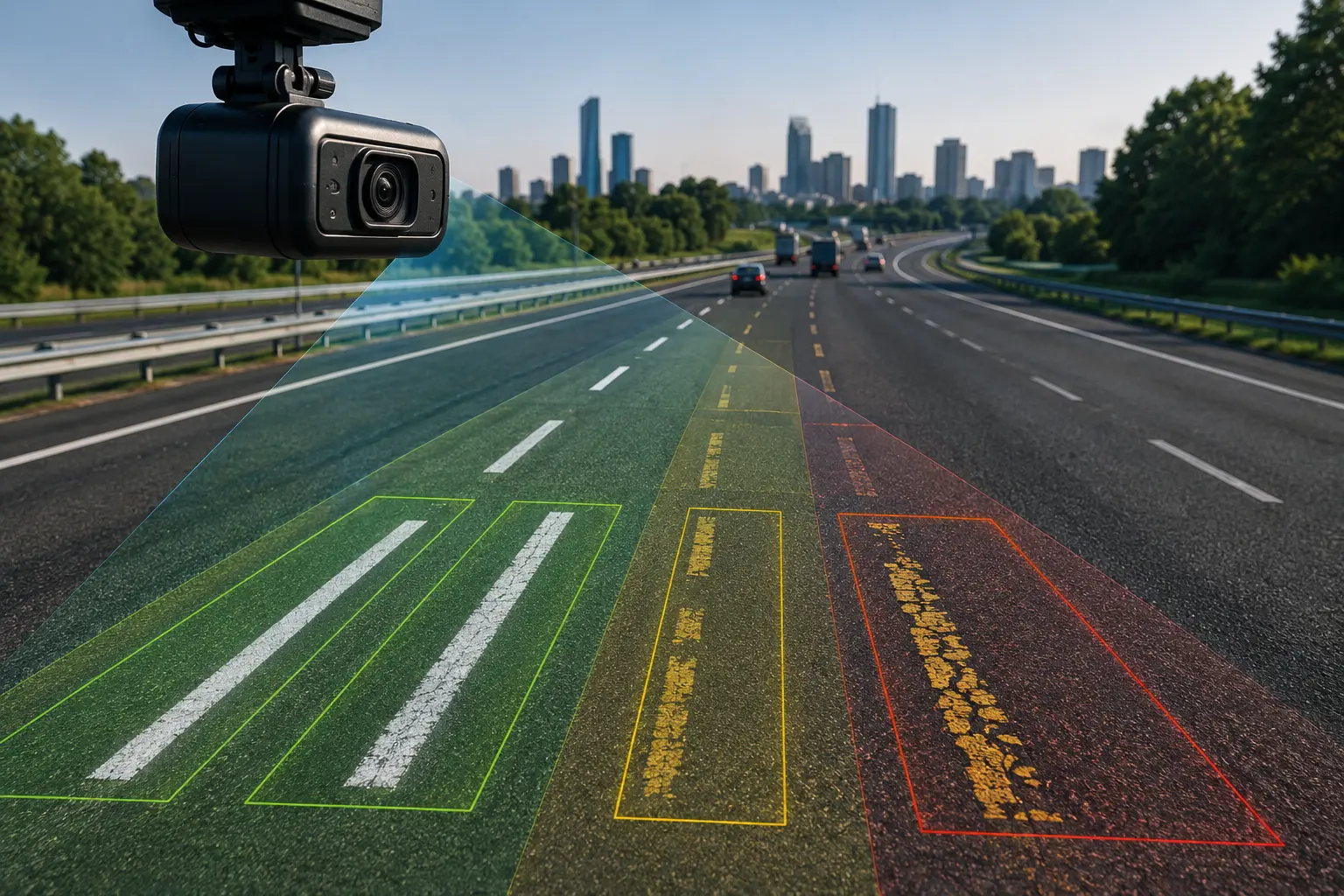
An AI road monitoring system is a technology platform that uses computer vision, machine learning, and standards-based engineering logic to automatically detect, assess, and report on the condition of road infrastructure pavement, safety assets, signage, structures, traffic, and surrounding environment continuously and at network scale, rather than through periodic manual inspection.
Unlike traditional inspection software, which is largely a digital filing cabinet for manually entered survey data, a true AI road monitoring system performs the assessment itself. It looks at imagery and sensor data, applies engineering standards, classifies defects and risks, and produces structured, location-specific outputs that engineers and asset managers can act on directly.
RoadVision AI's platform is built around four core capabilities that define this category:
Multi-source data collection — ingesting imagery and sensor data from satellites, vehicle-mounted dashcams, drones, and other sources into a single processing pipeline, rather than requiring a dedicated survey vehicle for every data type.
Standards-aware AI processing — evaluating road condition not against generic thresholds but against the specific engineering codes that govern a given jurisdiction, including IRC, MoRTH, ASTM, AASHTO, PAS, and client-defined standard operating procedures.
Specialist agent execution — rather than one general-purpose model trying to do everything, the platform deploys targeted AI agents, each built for a specific domain: pavement condition, roadside assets, traffic, safety auditing, vegetation, construction monitoring, and more.
Actionable delivery — outputs are not raw data dumps. They arrive as interactive dashboards, structured reports, and developer-ready APIs that integrate directly into a road authority's existing asset management and decision-making workflows.
RoadVision AI's architecture follows a clear four-stage pipeline, taking raw road data through to engineering decisions.
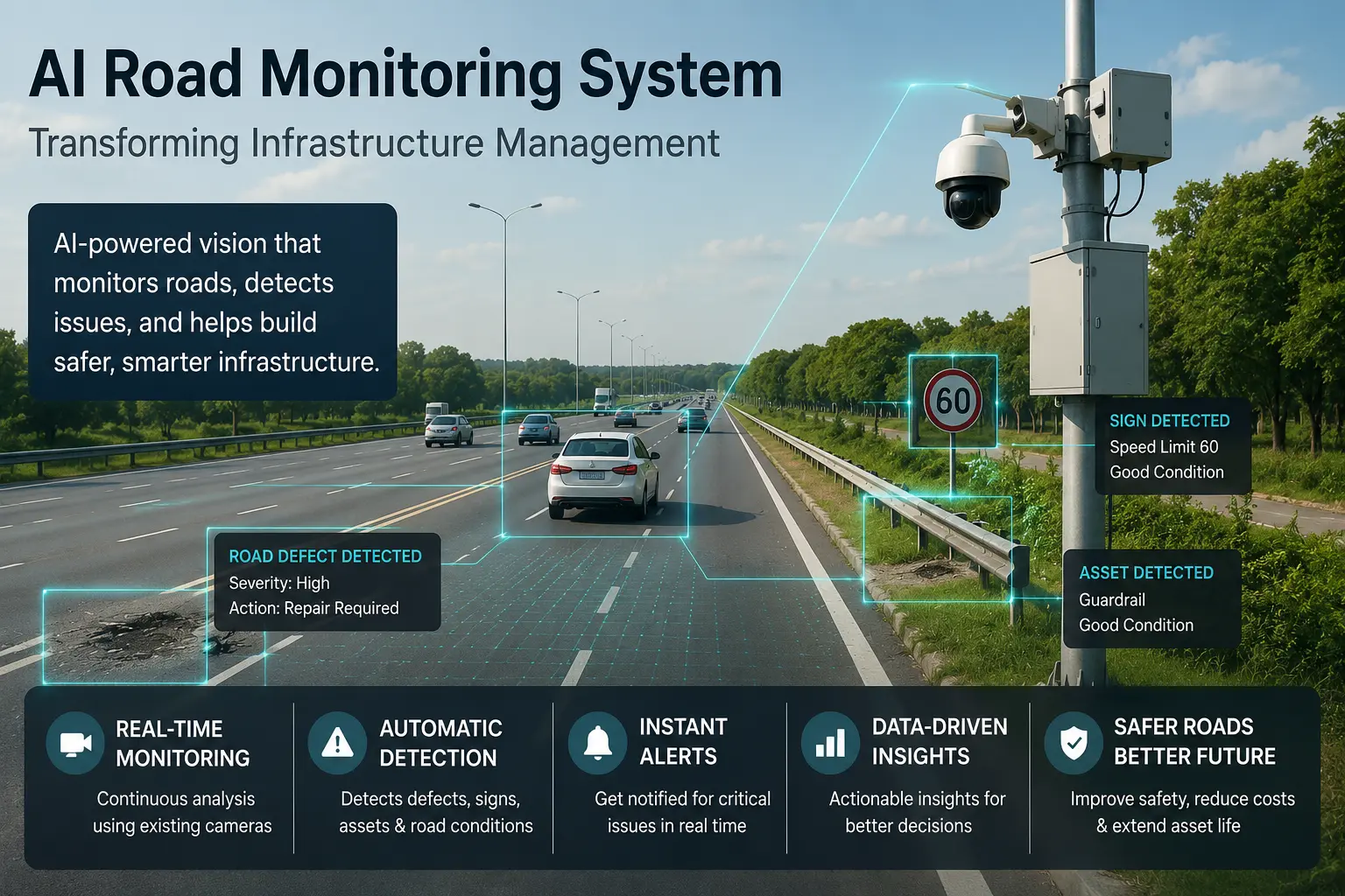
The platform ingests imagery and sensor data from whatever sources a client already has or chooses to deploy satellite imagery for broad network coverage and change detection, dashcam footage from maintenance and patrol vehicles already on the road, and drone imagery for detailed inspection of specific assets, structures, or hard-to-access locations. Because the platform is built to consume multiple data sources into a single pipeline, road authorities are not locked into a single, expensive, dedicated survey methodology they can use the data collection method that fits each part of their network and budget.
Collected data is processed by RoadGPT, RoadVision AI's core AI engine for pavement and road condition intelligence. RoadGPT analyzes incoming imagery and sensor data against more than 50 engineering standards, including the Indian Roads Congress (IRC) codes, India's Ministry of Road Transport and Highways (MoRTH) specifications, ASTM International standards, AASHTO guidelines, and other regional and client-specific frameworks. This standards-aware processing is what separates an engineering-grade AI road monitoring system from a generic computer vision tool the platform is not simply detecting a crack, it is assessing whether that crack constitutes a defined defect under the relevant code, and what response that code calls for.
Once data has been processed, specialist AI agents perform targeted analysis across three broad domains: road network monitoring, road safety, and workflow automation. Each agent is purpose-built for a specific function pavement condition assessment, roadside asset inventory, traffic analysis, safety auditing, and more — rather than relying on one generalized model to handle every type of road engineering question. This agent-based architecture allows RoadVision AI to go deep on each domain, continuously improving accuracy and standards alignment for that specific function, rather than spreading capability thin across an undifferentiated platform.
The final outputs are designed for the people who actually have to act on them. Findings are delivered through interactive dashboards that let asset managers explore network condition geographically, detailed reports formatted for engineering review and regulatory compliance, and developer-ready APIs that allow road authorities and consultants to pull RoadVision AI's outputs directly into their existing road asset management systems (RAMS), GIS platforms, and maintenance contractor workflows without re-entering data or maintaining a second, parallel system.
The platform is explicitly designed to integrate, not replace exporting to standard formats including PDFs, GIS layers, CSV files, maintenance schedules, and compliance reports, and working alongside the asset management and GIS systems a road authority already has in place.
RoadVision AI's "Autonomous Road Engineer" is not a single tool it is a suite of specialist agents organized across three categories that together cover the full road lifecycle.
Pavement Condition Intelligence Agent evaluates pavement condition using standards-aware intelligence aligned with IRC, MoRTH, ASTM, AASHTO, PAS, and client SOPs — identifying cracking, potholes, rutting, and other surface distress and converting it into engineering-grade condition indices.
Roadside Assets Inventory Agent tracks and assesses signs, barriers, and roadside assets with engineering-grade precision, building and maintaining a digital inventory that most road authorities have historically managed through fragmented paper or spreadsheet records.
Construction Monitoring Agent autonomously monitors project progress, quality, and compliance across construction stages — giving owners and consultants continuous visibility into whether a project is meeting design and schedule commitments without waiting for periodic site visits.
Rapid Road Damage Assessment Agent uses satellite imagery and AI to rapidly assess post-disaster road damage, giving emergency response and reconstruction planning teams a fast, network-wide damage picture after floods, earthquakes, or other disruptive events.
Road Beauty and Sanitation Agent monitors roadside cleanliness, aesthetics, and urban quality indicators — a less obvious but increasingly important metric for municipal corporations managing public perception of road quality.
Road Vegetation Analysis Agent monitors roadside vegetation for safety and green highway compliance using dashcam and satellite data, flagging overgrowth that obstructs sightlines or signage before it becomes a safety hazard.
Road Safety Audit Agent conducts design, pre-operation, and operations-and-maintenance safety audits, producing chainage-wise risk reports aligned with IRC, AASHTO, and WHO road safety benchmarks. This agent specifically addresses the gap between episodic formal safety audits — typically conducted yearly or less — and the daily reality that road conditions change continuously between those audit cycles.
Traffic Analysis Agent automates traffic counting, vehicle classification, and congestion analysis for planning and revenue optimization — a capability that has direct commercial relevance for toll concessionaires evaluating bid economics.
Automatic Number Plate Recognition Agent detects, reads, and tracks vehicle number plates from live video feeds in real time, supporting enforcement, tolling, and traffic intelligence applications.
AI-Based Facial Recognition Agent identifies, tracks, and monitors personnel presence in active work zones and infrastructure environments a workforce safety and compliance application specific to construction and maintenance operations.
Blackspot Analysis Agent identifies accident-prone zones and recommends targeted safety interventions, correlating crash history with road geometry, signage, and condition data to prioritize where safety investment will have the greatest impact.
Enterprise DMS & Workflow Agent automates engineering and asset workflows with Design–As Built–As Maintained traceability, addressing the document management chaos that plagues large infrastructure projects as they move from design intent through construction reality to ongoing maintenance records.
Tender Intelligence & Bid Preparation Agent tracks tenders, extracts templates, and assists bid creation using AI helping contractors and consultants identify and respond to procurement opportunities faster and more accurately.
Contract Intelligence & Management Agent reviews contracts, identifies risks, and supports claims and litigation management bringing AI-assisted document review to one of the most legally consequential and time-intensive aspects of infrastructure project delivery.
Among RoadVision AI's agents, the Road Safety Audit Agent illustrates particularly well how the platform's standards-aware, continuous approach differs from traditional practice.
Traditional road safety audits are episodic by design conducted at fixed project milestones (design review, pre-opening, periodic operations review) rather than continuously. This creates three recurring gaps. During design, safety risks embedded in drawings often go undetected until construction or operation, when remediation is dramatically more expensive. During pre-opening, readiness checks are typically manual and checklist-based, leaving room for missed details. And during operations, roads degrade continuously while formal audits happen only yearly or less meaning emerging risks can go unnoticed for months between audit cycles.
RoadVision AI's agent addresses this through a structured pipeline: ingesting design drawings, video, and accident data; assessing conditions against applicable safety standards; classifying findings into high, medium, and low severity; analyzing correlations between conditions and accident patterns; generating a prioritized list of recommended interventions; and producing location-specific safety reports.
Coverage spans the full safety-relevant scope of a road corridor geometry and alignment, sight distance at curves and junctions, signage design and visibility, barrier and guardrail condition, road surface hazards, vegetation encroachment, and structural elements including vehicular underpasses, bridges, grade separations, and entry/exit ramps. The output is delivered through a dashboard offering a chainage-wise risk map, severity classification, blackspot correlation, a prioritized recommendation list with cost estimates, and a compliance status view mapped to IRC and MoRTH requirements.
Importantly, RoadVision AI is explicit that this agent augments formal safety audits rather than replacing them providing continuous, evidence-backed findings between formal audit cycles that strengthen, rather than substitute for, the work of qualified safety auditors.
A recurring theme across RoadVision AI's platform and a meaningful differentiator versus generic computer vision tools repurposed for roads is its grounding in recognized engineering codes. Processing against more than 50 standards, including IRC, MoRTH, ASTM, and AASHTO, means that outputs are not just defect detections; they are findings that road engineers, auditors, and regulators can directly map to the compliance frameworks they are already accountable to.
This matters in practice for several reasons. Engineering teams need outputs they can defend in design review meetings and regulatory submissions, not just visually compelling dashboards. Consultants conducting audits on behalf of clients need documentation that is "regulatory-ready" rather than requiring translation into compliance language after the fact. And government road authorities need confidence that AI-generated findings reflect the same codes their own engineering departments are required to apply not a black-box scoring system with no traceable basis.
RoadVision AI's platform is built around the reality that very different stakeholders touch a road network across its lifecycle, each with different needs from the same underlying data.
Construction firms use the platform for real-time quality monitoring and compliance tracking during active project delivery, catching deviations from design and specification before they compound into costly rework.
Operators and concessionaires rely on continuous condition and traffic analysis to manage toll roads and operated assets, supporting both day-to-day maintenance decisions and longer-term revenue and investment planning.
Asset managers use AI-driven infrastructure asset management capabilities to maintain accurate, current inventories of pavement and roadside assets across networks too large to track manually.
Consultants use the platform to scale delivery without scaling headcount taking on larger inspection, audit, and advisory mandates without a proportional increase in field staff.
Investors use the platform for due diligence and portfolio tracking, gaining independent, data-backed visibility into the physical condition of road assets under consideration or already held.
Government road authorities use network-wide visibility for planning and budgeting, replacing fragmented, inspection-cycle-driven data with a continuously updated picture of network condition that supports more defensible capital allocation decisions.
The core argument for an AI road monitoring system is straightforward economics. RoadVision AI frames the problem precisely: without real-time data and predictive maintenance, reactive repairs cost roughly 10 times more than proactive intervention, and network blindness not knowing the true condition of large parts of a network compounds that cost over time.
This plays out through several recurring patterns. Manual field inspection covers only a fraction of a network in the time available, leaving the rest effectively unmonitored between cycles. Data captured by different teams and systems remains fragmented, making holistic, network-wide analysis difficult or impossible. The engineering expertise required to interpret road condition data does not scale at the same rate as network growth, creating a persistent capacity gap. Conditions that are assessed quarterly or annually create blind spots in between, during which a manageable defect can progress into a structural failure. And because decisions lag behind actual conditions, what would have been a modest, planned intervention becomes an unplanned emergency repair at several times the cost.
An AI road monitoring system addresses each of these points directly not by replacing engineering judgment, but by giving engineers continuous, standards-aligned visibility into a network at a scale and frequency that manual processes cannot match, so that decisions about where to intervene, and when, are made earlier and with better information.
RoadVision AI's platform has been deployed across more than 20,000 miles of road in 17 countries spanning North America, South America, Europe, the Middle East, Africa, Asia, and Oceania, working with organizations ranging from municipal corporations and state public works departments to highway concessionaires, international development institutions, and engineering consultancies. The platform is built API-first for integration into existing systems, and operates under recognized security and compliance frameworks including ISO 27001, SOC 2, and GDPR, with infrastructure hosted on AWS-certified environments.
What distinguishes the platform is its combination of breadth and depth: breadth, in that a single platform spans pavement, safety, assets, traffic, construction monitoring, and procurement workflows rather than requiring separate point solutions for each; and depth, in that each function is delivered by a dedicated, standards-aware AI agent rather than a single generalized model stretched across every use case. Outputs are designed from the outset to integrate with the asset management, GIS, and contractor systems road authorities already operate, rather than asking organizations to abandon existing infrastructure to adopt a new one.
The gap between how large road networks have become and how road authorities are equipped to manage them is not a temporary inefficiency it is a structural problem that grows worse every year networks expand faster than inspection capacity. Reactive, inspection-cycle-driven road management was never designed for networks of today's scale, and the cost of that mismatch shows up directly in emergency repair bills, missed safety risks, and infrastructure budgets that never quite stretch far enough.
RoadVision AI's Autonomous Road Engineer represents a different model one where satellite, dashcam, and drone data feed continuously into standards-aware AI agents that assess pavement, safety, assets, traffic, and project delivery with the consistency and coverage that manual processes cannot match, and deliver findings directly into the workflows road authorities, consultants, and operators already use. Deployed across 20,000-plus miles in 17 countries, the platform demonstrates that this shift from reactive to predictive road management is not a future concept it is operating today.
Ready to see what an Autonomous Road Engineer can do for your network? Contact RoadVision AI to book a demonstration or explore the live and beta agents available today.
Traditional road inspection software is primarily a digital record-keeping tool for data that humans collect and assess manually. An AI road monitoring system, like RoadVision AI's platform, performs the assessment itself using computer vision and machine learning to detect and classify road conditions directly from imagery and sensor data, evaluated against recognized engineering standards, with minimal manual data entry required.
The platform ingests data from multiple sources into a single processing pipeline, including satellite imagery, dashcam footage from vehicles already operating on the network, and drone imagery for detailed or hard-to-access inspections. This multi-source approach allows road authorities to use whichever data collection method best fits a given part of their network rather than being locked into one survey methodology.
RoadVision AI's core processing engine, RoadGPT, evaluates road condition against more than 50 standards, including the Indian Roads Congress (IRC) codes, India's Ministry of Road Transport and Highways (MoRTH) specifications, ASTM International standards, AASHTO guidelines, PAS standards, and client-specific standard operating procedures, ensuring findings map directly to the compliance frameworks engineering teams already work within.
No. RoadVision AI's agents, including the Road Safety Audit Agent, are designed to augment professional engineering and audit work with continuous, evidence-backed data between formal review cycles — not to replace the judgment of qualified engineers and auditors. The platform produces standards-aligned findings that support and accelerate professional review rather than substituting for it.

The Autonomous Road Engineer
AI that is transforming road infrastructure, from reactive to predictive.