This is a project-level account from RoadVision AI's consolidated road and asset assessment in Uzbekistan, carried out on more than 150 parameters using 360-degree data along the Tashkent Ring Road, D001. Rather than a list of faults, it gives the road owner a complete picture of the ring: what is on the road, which of those things are authorised, and what shape the road and its edges are in. It sets out how the assessment worked, what it shows, and why one consolidated record earns its keep.
A road owner needs to answer two questions at once: what is on the road, and what shape is it in? The first is an inventory question. The second is a condition question. They are usually answered by separate surveys, with separate data and separate positions, so the two never quite line up.
This assessment answers both together, and it is careful about what each answer means. On the inventory side, it records every asset it can see: signs, markings, lighting, structures and roadside installations. It records them whether they are authorised or unauthorised, and whether they are in good order or damaged. Most assets are neither damaged nor unauthorised, and they are recorded all the same. Unauthorised is a status that applies only to assets, such as a hoarding or signboard put up without approval, and the inventory shows which assets carry it and which do not. On the condition side, it separately records defects in the road and its edges, such as cracking, potholes, patching and drainage problems.
The point of recording everything, and not only what is wrong, is that the owner can see the whole picture: what is right, what is wrong, and what should not be there.
D001 is the Tashkent Ring Road (THAY, formerly M39b), a road of state importance. According to the register of Uzbekistan's roads, it is about 67 km long in total and circles the capital.
One stretch of the ring, the 7 km between km 50 and km 57, shows its setting well. It forms the south-western part of the ring, runs along the boundary of Tashkent city (the Olmazor and Shayxontohur districts) and Tashkent district (around Keles and Hasanboy), and continues to the point where it meets the M39 highway on the Tashkent–Kazakhstan border route. At km 49, the D004 road towards Keles and Ko'ksaroy branches off the ring.
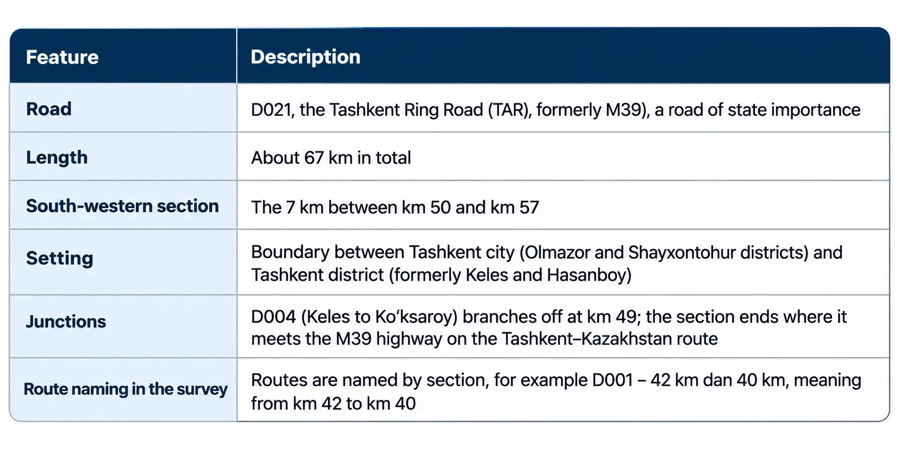
A ring road typically does several jobs at once. It carries traffic around the capital, links the districts that surround it, and connects to the highways that leave the city. It also runs through places where the city meets its outskirts, with a changing mix of built-up frontage, junctions and roadside installations, which is why it rewards being looked at as a whole.
RoadVision AI carried out one consolidated road and asset assessment on more than 150 parameters, using 360-degree data. The survey covered 65.08 km, against a ring road of about 67 km in total. The data was uploaded to the platform, where AI detected assets and defects in the footage, and each detection became a record with an ID, a position, a route and a survey date, held in the Asset Library or the Defect Library with the original video one click away.
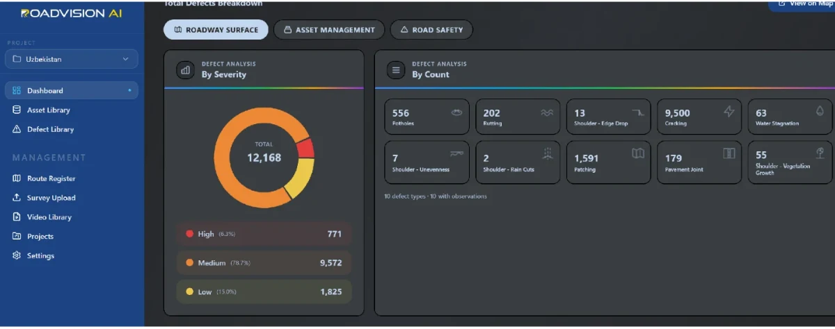
Assets fall into six categories (Directional Signage, ITS, OIA, Pavement, Roadway Lighting and Structures), and defects into three groups (Roadway Surface, Asset Management and Road Safety). Altogether the assessment produced more than 32,000 detections, made up of 15,888 assets and 16,713 defects. The assets are an inventory, most of it authorised and in good order. The defects are findings in the road and its edges. Reading the two together is what turns a long list into a picture of the road.
A ring road runs through a wide variety of surroundings. The photograph below, an illustrative image of a tree-lined multi-lane urban road in Tashkent, shows the kind of scene an assessment has to read: a wide carriageway with dashed lane markings, a kerbed verge with a flower bed, mature trees, street lighting and modern buildings in the distance.
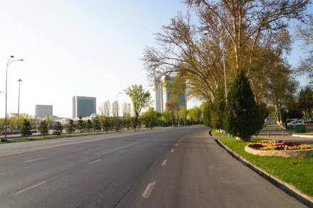
Each of those things is a different kind of finding. The markings, kerbs and lighting are assets. The condition of the surface is a defect question. Overhanging planting can hide signs or markings. A qualitative reading of the road keeps all of them in view, and the consolidated assessment is built to do that.
The road surface. Based on the detections, only a small part of the ring is in Good condition: 7.28 km. About half, 33.09 km, is Fair, and 24.70 km is Poor, as the Road Roughness panel on the Network Dashboard in Figure 2 shows. In plain terms, the ring is mostly acceptable but ageing, and a little under two-fifths of it needs attention first.
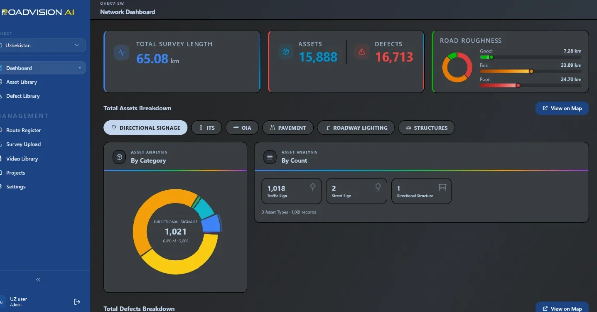
The assets. The inventory is large and varied, spanning directional signage, ITS, OIA, pavement, roadway lighting and structures. Within directional signage, traffic signs account for almost all of the records, with a handful of street signs and a single directional structure. All of these are recorded whether or not they are authorised and whether or not they are damaged.
The defects. Cracking dominates the roadway surface defects by a wide margin. Patching, which marks places where earlier repairs have been made, comes second, while potholes and rutting appear but are comparatively few, as Figure 3 shows. Most defects are of Medium severity, with a small group of High-severity defects to deal with first.
To see what the records look like on the ground, take a few of them. The Defect Library, shown in Figure 4, holds every record with its position, type, side of the road and survey date, beside a map of the route and the video frame with the detection marked.
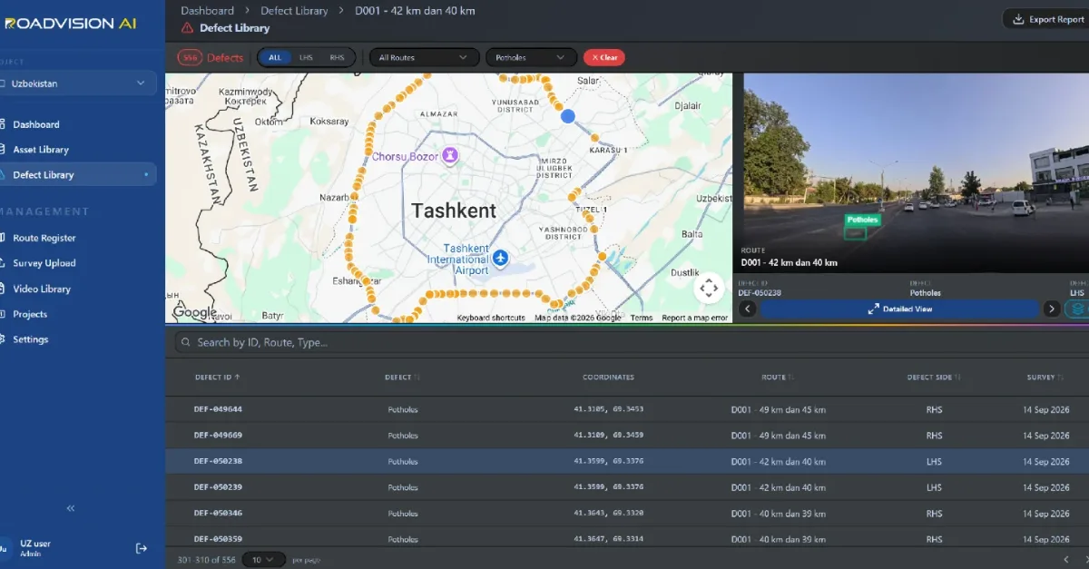
In the selected frame, a busy urban setting of shopfronts, parked and moving vehicles and pedestrians, a pothole has been flagged in the lane. The six records below, all surveyed on 14 September 2026, come from three sections of D001.
Read as a short tour of the ring, the records show potholes in pairs: two on one section, two on the next, two on the next. Two of them, DEF-050238 and DEF-050239, share the same position to four decimal places. That may mean two potholes side by side or one pothole seen in two frames, and the QC step in the library is there to settle it.
None of this is dramatic. Potholes in a busy urban section are ordinary wear, and the value lies in seeing each one in position, with its photograph, on a single record.
A ring that needs attention. Only a small part of the ring is in Good condition, so the larger task is keeping the Fair stretches from sliding into Poor while treating the Poor ones first.
Surface wear is the main story. Cracking dominates the defects. Cracks that are sealed in time are much cheaper to deal with than the potholes they turn into.
An inventory worth having. The assets are mostly in order, and knowing where every sign, light and marking is, and which are authorised, is valuable in its own right.
A baseline for repeat surveys. A later survey of the same sections shows what has been repaired, what has deteriorated and what has been added, without anyone walking the road again.
Scale and consistency. More than 150 parameters mean that definitions have to be applied consistently along the whole ring.
Urban surroundings. The frames show busy streets with parked vehicles, pedestrians and buildings close to the carriageway. These can block the view of the road surface and degrade GPS positioning, so positions and detections are checked against the map and the video.
Assets and defects. The detections combine two kinds of record. Assets are an inventory, not a list of faults, and unauthorised is a status that applies only to assets.
Classification and review. The Good, Fair and Poor classification is drawn from the detections and shown on the dashboard as Road Roughness. Detections carry a QC step, and records that look alike, such as two with matching positions, are reviewed before totals are relied on.
Each assessment gives the road owner an ID, a position and a route reference for every asset and defect, independent of the agency doing the work. A later survey of the same sections then shows whether a finding has been closed out, so that verification does not rest on the maintaining agency's own account.
RoadVision AI is committed to keeping this assessment current, survey after survey, giving the road owner one consistent picture of what the Tashkent Ring Road holds and how it is holding up. That is how a single assessment becomes a tool for managing the road year after year.

The Autonomous Road Engineer
AI-powered road condition monitoring, asset management, & infrastructure intelligence helping agencies move from reactive maintenance to predictive road management.