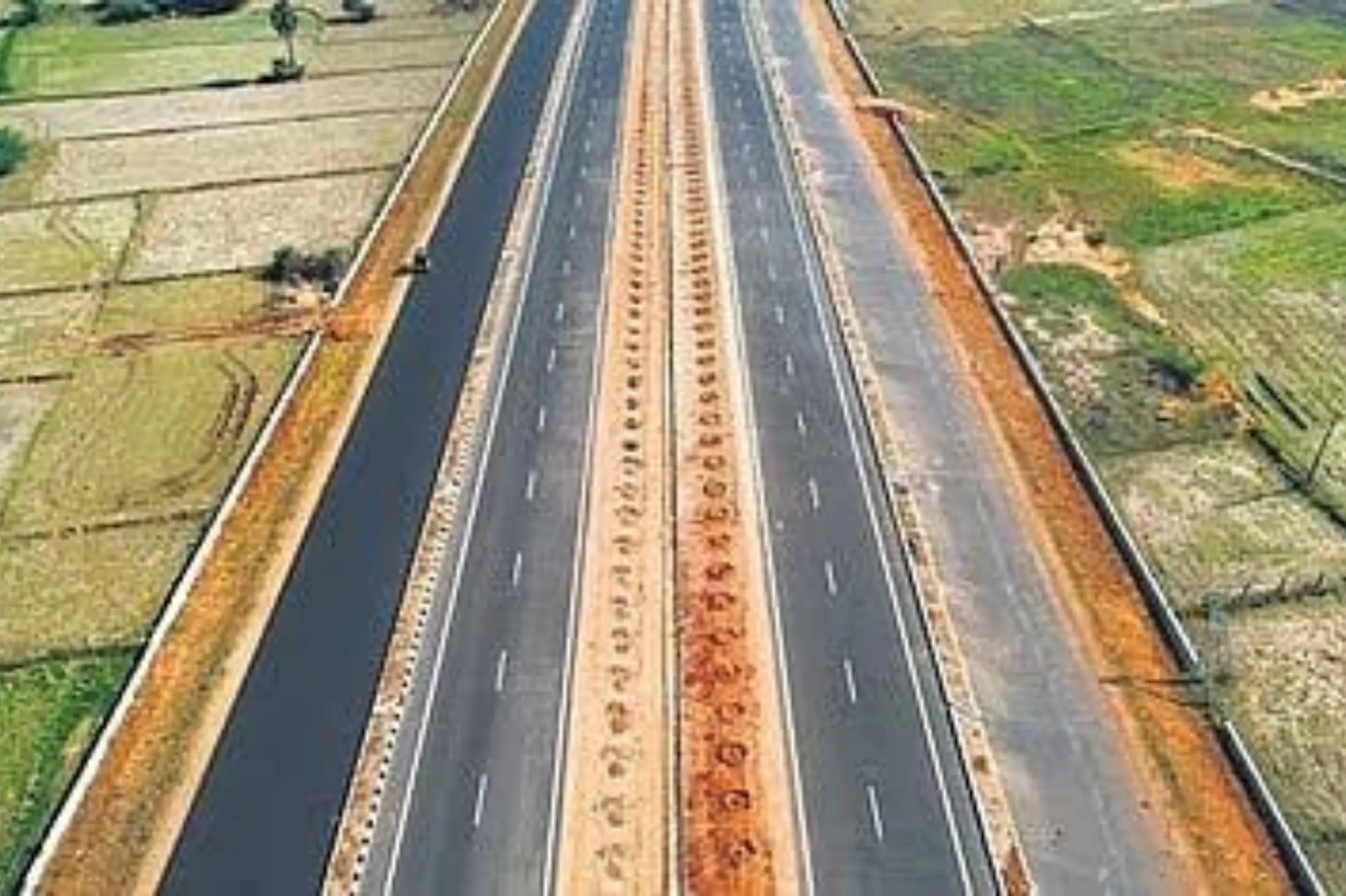
This is a project-level account from RoadVision AI's road survey programme for NHAI's Guwahati Regional Office, covering two connected projects under SARDP-NE: the four-laning of the Jorabat – Shillong (Barapani) section of NH-40, km 0.000 to km 61.800, in Assam and Meghalaya, on DBFOT pattern, and the two-laning of the Shillong Bypass connecting km 61.80 of NH-40 to km 34.85 of NH-44 in Meghalaya, on BOT (Annuity) mode. It sets out what the surveys found, why this corridor matters, and what makes data collection on a hill road difficult.
The Jorabat – Shillong (Barapani) section of NH-40, now designated NH-6, runs 61.8 km from km 0.000 at Jorabat in Assam to Barapani near Shillong in Meghalaya. As publicly described, it is a four-laning project on a Design, Build, Finance, Operate and Transfer (DBFOT) / BOT (Annuity) model under the Special Accelerated Road Development Programme for the North East (SARDP-NE) Phase A. The survey record carries 95.5 km of road.
The Shillong Bypass is a two-lane road connecting km 61.80 of NH-40, near Barapani, to km 34.85 of NH-44 in Meghalaya, also under SARDP-NE on BOT (Annuity) mode. As publicly described, it spans roughly 48.76 km of main carriageway, mostly flexible pavement, through rolling and hilly terrain, bypassing Bhoilymbong and passing small settlements such as Umroi, Nongtrah, Diengpasoh and Thangshalai, with one toll plaza and 13 bus bays with shelters. The survey record carries 47.9 km of road.
Together the two roads form a gateway into Meghalaya. The four-lane section links Jorabat, on the edge of Guwahati, to Shillong, the state capital, and the bypass carries traffic around the Shillong area onto NH-44, which leads on towards southern Assam and Tripura. SARDP-NE exists to improve road connectivity across the North East, where hill terrain, heavy rain and few alternative routes mean a single road often carries most of the freight, tourist and daily traffic. Both projects are delivered on a BOT (Annuity) model, in which the developer builds the road and maintains it over a long operating period, with annuity payments that depend on the road being kept to standard. That makes it important to know, independently of the developer's own reporting, how the road actually looks on the ground. A consistent, chainage-tied record shows what is wrong, how urgent it is, and whether it has been put right by the next survey.
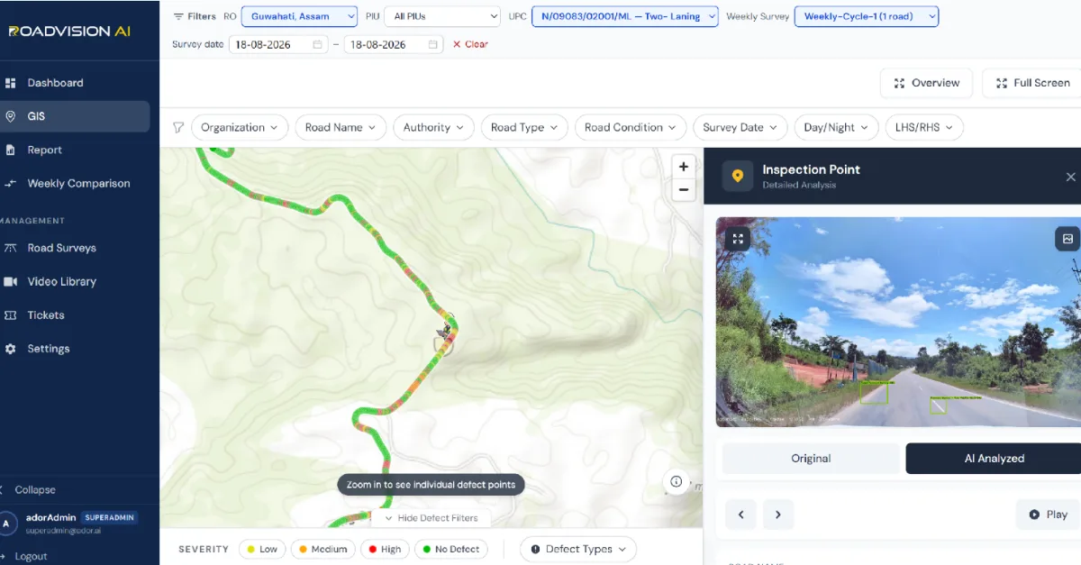
Every finding sits on a live GIS map, with each inspection point opening to its exact location, the defect flagged, and the frame behind it in both original and AI-annotated form. Figure 1 shows the Shillong Bypass for the survey of 18 August 2026, winding through hilly terrain, with an inspection point captured at about 12:40 pm flagging faded pavement marking and poor day-time marking visibility on a curve between a red-soil cutting and dense roadside vegetation. A frame like this shows the setting the survey works in: steep, curving, heavily vegetated, and subject to rapidly changing light.
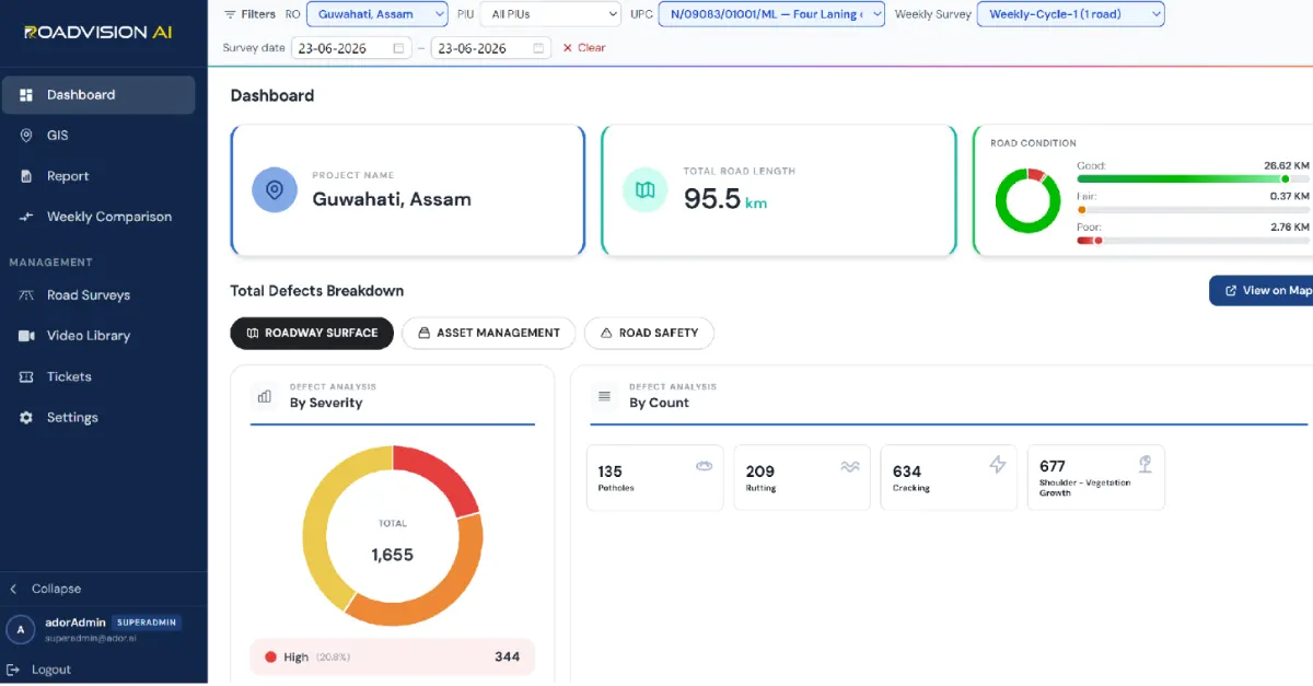
The four-lane Jorabat – Shillong report for the survey of 23 June 2026 rated 29.75 km of the 95.5 km on the record: 26.62 km (89.5%) Good, 0.37 km (1.2%) Fair and 2.76 km (9.3%) Poor. In the roadway-surface view, RoadVision AI logged 1,655 findings across four defect types. Shoulder vegetation growth accounts for 677 (40.9%), cracking for 634 (38.3%), rutting for 209 (12.6%) and potholes for 135 (8.2%). Of these, 344 (20.8%) are High severity.
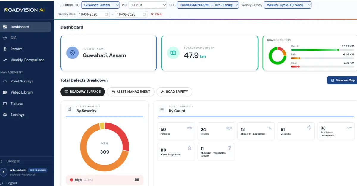
The Shillong Bypass dashboard for the survey of 18 August 2026 rated 47.86 km of the 47.9 km on the record: 35.62 km (74.4%) Good, 6.46 km (13.5%) Fair and 5.78 km (12.1%) Poor, as Figure 3 shows. RoadVision AI logged 309 findings across seven defect types. Water stagnation accounts for 118 (38.2%), cracking for 61 (19.7%), potholes for 50 (16.2%), shoulder unevenness for 33 (10.7%), rutting for 24 (7.8%), shoulder edge drop for 12 (3.9%) and shoulder vegetation growth for 11 (3.6%). Of these, 86 (27.8%) are High severity. The two surveys fall on different dates, one in June and one in August, both within the monsoon season, so they are snapshots rather than a like-for-like trend.
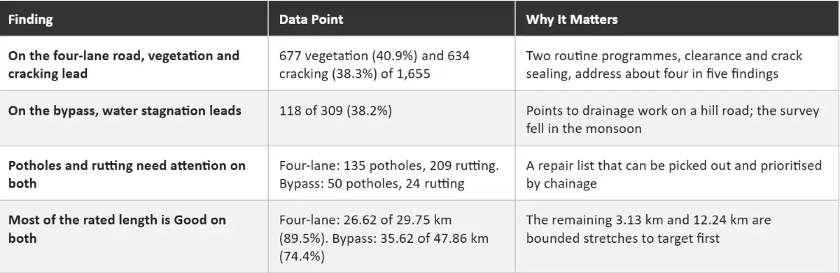
Surveying a hill corridor like this is harder than surveying a plains highway, and the difficulties shape how the findings should be read.
Terrain and GPS. The Shillong Bypass winds through rolling and hilly terrain, with tight curves and changing gradients, as Figure 1 shows. Under tree cover and in valleys, GPS signals can drift, which risks placing a finding on the wrong chainage and calls for checking against the map.
Light and weather. Monsoon cloud, rain, mist and spray affect the camera, and a single frame can mix bright sunlight with deep shade. Both surveys fell in the monsoon months, on 23 June and 18 August, so wet surfaces and standing water are part of what was recorded.
Vegetation. Dense roadside growth can hide kerbs, signs and markings while also being a defect in itself, with 677 shoulder vegetation findings on the four-lane road. The survey has to separate what is a defect from what is simply hiding one.
Traffic and speed. On two-lane stretches with heavy goods vehicles, curves and few places to overtake, the survey vehicle cannot always hold a steady speed or a clear line of sight to the carriageway edge.
Coverage and rating. On the four-lane section, 29.75 km of the 95.5 km on the record carries a condition rating, and a divided carriageway is surveyed carriageway by carriageway, so survey length does not match project length. The Good, Fair and Poor split is best read as a rated sample rather than a full count.
Snapshots and seasons. Each survey is a single day. Vegetation, standing water and potholes can change within weeks in the monsoon, so repeated surveys of the same chainage matter more here than one large survey.
Each survey gives the Guwahati Regional Office a defect ID, chainage and survey reference for every finding, independent of the agency doing the work. A later survey of the same chainage then shows whether the finding has been closed out, so that verification does not rest on the developer's own account.
RoadVision AI is committed to continuous AI-based hill road monitoring along NH-6 (formerly NH-40) from Jorabat to Shillong and around the Shillong Bypass, giving NHAI a consistent, chainage-level record of a gateway corridor into the hills. Keeping that record current, survey after survey, is how upkeep on a hill road can be shown to be doing its job.

The Autonomous Road Engineer
AI-powered road condition monitoring, asset management, & infrastructure intelligence helping agencies move from reactive maintenance to predictive road management.