
Mountain and hill roads present some of the most difficult infrastructure management challenges anywhere in the world. Steep gradients, unstable slopes, narrow carriageways, and unpredictable geological conditions combine to create environments where a single undetected hazard a hairline crack in a slope, a slow accumulation of loose debris, water seeping into a fracture line can escalate into a life-threatening landslide within hours. Traditional inspection methods, already strained on flat urban roads, become even harder to execute safely and consistently on terrain where inspectors themselves face genuine physical risk.
AI-powered road monitoring and landslide detection technology is increasingly being applied to mountain road corridors, offering the potential to identify early warning signs and support safer, more proactive maintenance. But hill roads also present unique technical challenges that don't exist on flatter terrain, requiring specialized approaches rather than simply applying standard road monitoring tools. In this blog, we'll explore how mountain road inspection works, the role AI plays in landslide detection, and the specific challenges that make hill road monitoring uniquely difficult.
Mountain and hill road corridors differ from standard urban or highway networks in ways that fundamentally change how inspection and monitoring need to be approached:
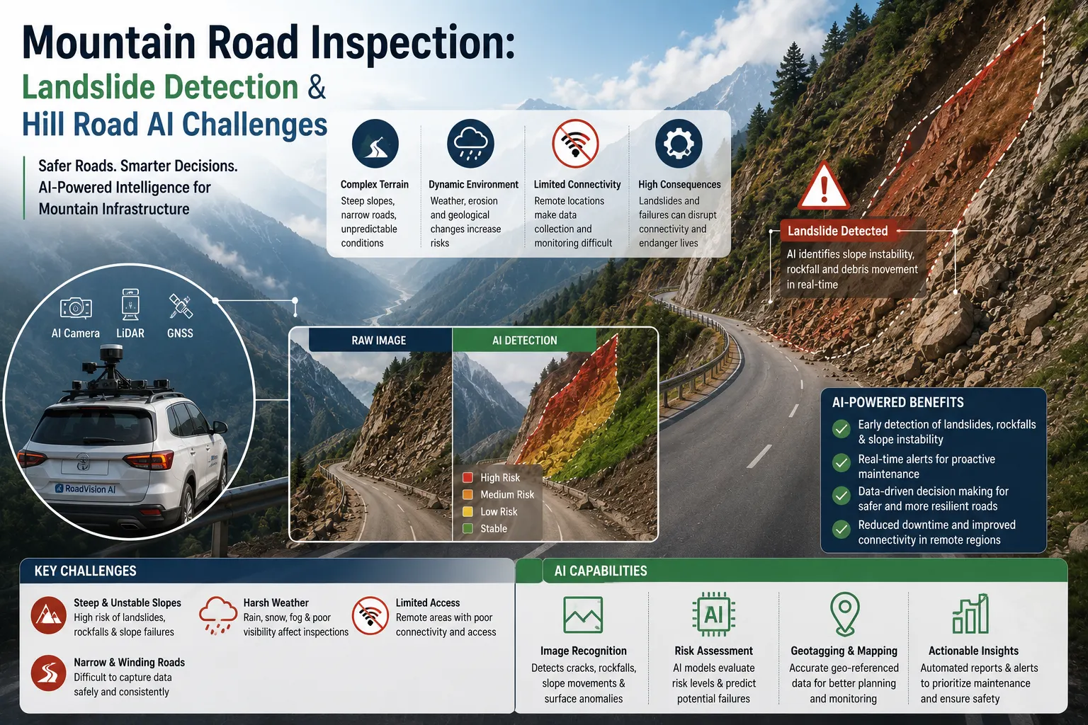
Landslide detection refers to the use of monitoring technology and analytical methods to identify early warning signs of slope instability along a road corridor, with the goal of predicting or detecting landslide risk before it results in a road closure, damage, or loss of life. This can range from monitoring visible surface changes to analyzing subsurface movement using specialized sensors.
Unlike general road condition monitoring, which primarily assesses the road surface itself, landslide detection must account for the broader geological and hydrological context surrounding the road the slope above it, the drainage patterns around it, and the vegetation and soil conditions that influence stability.
InSAR technology can detect extremely small ground movements sometimes just millimeters over large areas by comparing satellite radar images captured at different times. This makes it valuable for identifying slow-moving slope deformation that might precede a more significant landslide event, across areas too large or remote for ground-based monitoring alone.
Inclinometers, extensometers, and piezometers installed directly on or near vulnerable slopes can continuously measure ground movement, tilt, and groundwater pressure key indicators of slope stability providing localized, high-frequency data for specific high-risk sites.
Drones equipped with high-resolution cameras and LiDAR can capture detailed imagery and terrain models of slopes and road corridors that are difficult or dangerous to access on foot, supporting both routine monitoring and rapid post-event assessment.
Computer vision models can analyze drone, satellite, or fixed-camera imagery to detect visible warning signs new cracks, changes in vegetation patterns, water seepage, or minor debris accumulation that might indicate developing instability.
Since rainfall is one of the most significant triggers for landslides, monitoring systems increasingly integrate real-time and forecasted precipitation data, allowing risk models to account for weather conditions as a dynamic input rather than a static assumption.
In addition to slope-specific monitoring, standard road condition monitoring via vehicle-mounted cameras or fixed roadside cameras continues to play a role in detecting surface-level hazards like debris, cracking, or minor rockfall directly on the carriageway.
AI models can integrate and analyze data from multiple sources simultaneously—satellite deformation data, ground sensor readings, rainfall patterns, and imagery—identifying combined risk patterns that would be difficult for a human analyst to detect manually across such varied data types.
By analyzing historical landslide events alongside current slope, soil, and weather data, AI models can help generate predictive risk scores for specific road segments, supporting proactive closure decisions or targeted reinforcement work before a slope actually fails.
AI-based change detection algorithms can automatically compare successive satellite or drone imagery captures, flagging areas of a slope that show meaningful change since the last survey, directing limited expert attention to the areas of greatest concern.
Computer vision models trained specifically on landslide precursor indicators—surface cracking, bulging, vegetation stress, water seepage patterns—can help flag developing risks from routine imagery before they become visually obvious to an untrained observer.
Where ground sensor networks are deployed, AI systems can continuously monitor incoming data streams and generate automated alerts when readings exceed defined risk thresholds, supporting faster response than periodic manual data review would allow.
While the potential benefits are significant, mountain road inspection and landslide detection present genuinely difficult technical and operational challenges that distinguish this domain from standard road monitoring.
Steep gradients, dense vegetation cover, and narrow roads can limit the effectiveness of standard survey vehicles and even some drone operations, sometimes requiring specialized equipment or manual supplementation.
Many mountain and hill regions have limited or unreliable internet and cellular connectivity, complicating real-time data transmission from ground sensors or requiring more sophisticated offline data storage and periodic transmission strategies.
Landslide precursor signs can be subtle and easily confused with normal seasonal or vegetation changes, while some landslides occur with very little visible warning at all, making reliable AI-based prediction genuinely difficult and an active area of ongoing research.
Unlike road pavement, which behaves relatively consistently across different locations, slope stability is highly dependent on local geology, soil composition, and hydrology, meaning AI models often require significant site-specific calibration rather than simple one-size-fits-all deployment.
Ground-based sensors deployed on mountain slopes must withstand extreme weather, temperature fluctuations, and physical exposure, requiring robust, well-maintained hardware to ensure consistent, reliable data collection over time.
Because significant landslide events are relatively rare compared to routine road defects, AI models often have access to far less labeled training data for landslide prediction than for more common tasks like pothole detection, which can limit model accuracy and confidence, particularly for less-studied regions.
Given the life-safety consequences involved, there's a particular risk in over-relying on AI-generated risk scores without appropriate human geotechnical expertise involved in final decision-making, especially given the current limitations in reliably predicting rare, complex geological events.
As satellite technology, sensor networks, and AI models continue to advance, mountain road monitoring capabilities are likely to improve significantly, though genuine technical challenges will likely persist for some time. Emerging directions include:
Mountain road inspection and landslide detection represent one of the most technically demanding frontiers in AI-powered infrastructure monitoring. While technologies like satellite InSAR, ground sensor networks, and computer vision offer genuine promise for earlier hazard detection, the unique challenges of steep terrain, limited connectivity, complex site-specific geology, and inherently rare, hard-to-predict events mean that AI must be deployed as a support tool for not a replacement of qualified geotechnical expertise. As technology continues to mature, combined, multi-source monitoring approaches offer the best path toward safer, more resilient mountain road infrastructure, even as significant technical challenges remain an active area of ongoing development.
Landslide detection technology uses monitoring tools—such as satellite radar, ground sensors, drones, and AI-powered image analysis—to identify early warning signs of slope instability along road corridors before a landslide occurs.
AI models analyze data from multiple sources, including satellite deformation data, ground sensors, rainfall patterns, and imagery, to identify combined risk patterns and generate predictive risk assessments for specific road segments.
Interferometric Synthetic Aperture Radar (InSAR) is a satellite-based technology that detects small ground movements over large areas by comparing radar images captured at different times, useful for identifying slow slope deformation.
Mountain road monitoring must account for slope stability, difficult terrain access, limited connectivity, complex site-specific geology, and rapid-onset hazards, in addition to standard road surface condition assessment.

The Autonomous Road Engineer
AI-powered road condition monitoring, asset management, & infrastructure intelligence helping agencies move from reactive maintenance to predictive road management.


.webp)
.webp)
.webp)