
GIS-based road inventory software is a platform that stores a structured, map-based digital record of every road and roadside asset in a network road segments, pavement type, width, signage, drainage, guardrails, lighting, and more each tied to an exact geographic location. It replaces scattered spreadsheets, paper registers, and disconnected drawings with a single, searchable geospatial database. The inventory is the foundation layer for everything else in road management: you can't forecast deterioration, plan budgets, or prioritize maintenance on assets you haven't accurately recorded. Modern platforms increasingly use AI and vehicle-mounted cameras to build and update this inventory automatically instead of relying on slow, manual field surveys.
Most conversations about road technology jump straight to the exciting parts: AI defect detection, predictive maintenance, digital twins. But all of those capabilities quietly depend on something much less glamorous: knowing what you actually own. A deterioration model needs to know the age, material, and construction history of a road segment. A budget scenario needs to know how many kilometers of each road class exist. A maintenance crew dispatched to fix a damaged sign needs to know exactly where that sign is, and whether it was ever recorded in the first place.
Agencies that skip or underinvest in the inventory step tend to discover the gap later and painfully analytics that produce unreliable results because the underlying asset records are incomplete, budget requests that can't be defended because nobody can say with confidence how much road there actually is to maintain, and duplicated field visits because no one has a reliable map of what's already been surveyed. The inventory isn't a preliminary administrative task; it's the load-bearing foundation of the entire asset management program.
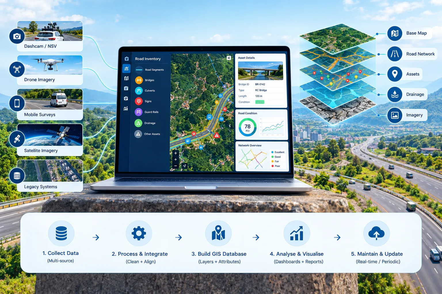
A road inventory typically holds two broad categories of information: what the asset is, and where it is.
The core of the inventory is the road network itself: every road segment with its identifier, classification (highway, arterial, local, rural), length, carriageway width, number of lanes, surface type, construction or last resurfacing date, and ownership or maintenance responsibility. For networks managed with linear referencing, each segment is also tied to a consistent chainage or milepost system so that any point along the road can be addressed precisely.
Beyond the pavement, a comprehensive inventory records the assets that sit along and around it: traffic signs and their condition, road markings, culverts and drainage structures, bridges and underpasses, guardrails and safety barriers, streetlights, traffic signals, footpaths, and road furniture. Each asset carries its own attributes, such as type, dimensions, material, installation date, and condition status.
A living inventory also tracks change over time: inspection history, maintenance and repair records, and condition scores from successive surveys. This is what turns a static register into a working management tool, since trends, not snapshots, are what drive good planning decisions.
A road inventory could, in principle, be a well-organized spreadsheet. The reason GIS-based platforms have become the standard is that roads are inherently spatial, and a lot of the most valuable questions about road assets are spatial questions.
Location is the primary key. In a GIS-based system, every asset has real geographic coordinates, not just a street name or a loosely described location. That precision matters when a crew needs to find a specific culvert, when two departments need to confirm they're talking about the same asset, or when an asset needs to be matched against survey imagery.
Spatial relationships become visible. Mapping assets reveals patterns that tables hide: a cluster of damaged signs along one corridor, pavement failures concentrated near a poorly drained low point, or a stretch of road where several assets all reach end-of-life at the same time and could be addressed in a single coordinated project.
Layers can be combined. GIS lets planners overlay the road inventory against other datasets: flood zones, traffic volumes, school and hospital locations, property boundaries, and administrative areas. That makes risk-based prioritization and right-of-way analysis far more practical than working from isolated lists.
Data stays connected to the real world. Linking each record to a location also makes it possible to attach photos, survey imagery, and inspection reports directly to the asset, so that anyone looking at a segment on the map can see its full history in one place.
The platform should support a structured asset schema that can be configured to your agency's classification system and attribute requirements, rather than forcing your assets into a rigid, one-size-fits-all template. Support for linear referencing is particularly valuable for road networks, since it lets you record where along a road an asset sits, not just which road it is on.
Planners and field staff should be able to explore the inventory visually, filtering by asset type, condition, location, or any other attribute, and clicking through from the map to full asset details and history.
A good platform supports building and updating the inventory from several sources: manual field entry through mobile apps, bulk import of existing spreadsheets and CAD or shapefile data, and automated capture from vehicle-mounted cameras and AI detection.
Because an inventory is only useful if it's trustworthy, look for validation features: duplicate detection, required-field checks, topology checks for network connectivity, and audit trails showing who changed what and when.
The inventory should connect cleanly with condition survey data, pavement management or maintenance management systems, work order platforms, and any existing enterprise GIS your agency already runs, rather than becoming another isolated data silo.
Different teams, from engineers to field crews to planners to external contractors, need different levels of access. Role-based permissions and multi-user editing keep the inventory current without creating version-control chaos.
Standard export formats and flexible reporting make it possible to share inventory data with regulators, funding bodies, and other agencies, and to generate the summaries that budget conversations require.
Historically, building a road inventory meant sending survey crews to physically walk or drive the network, recording every asset by hand. For large networks, that was slow, expensive, and out of date almost as soon as it was finished. AI has changed the economics considerably.
Automated asset detection from imagery. Computer vision models can scan imagery captured by vehicle-mounted cameras and automatically identify and locate signs, road markings, guardrails, culverts, streetlights, and other roadside assets, tagging each with GPS coordinates and creating inventory records without a human logging them individually.
Condition captured at the same time. The same imagery that identifies an asset can also assess its condition: a faded sign, a damaged guardrail, a blocked culvert inlet. That means the inventory and the condition record are built in a single pass rather than two separate survey efforts.
Change detection keeps the inventory current. By comparing successive survey passes, AI can flag assets that have appeared, disappeared, or changed since the last survey, such as a sign that's been knocked down, a new unrecorded installation, or an encroachment, so the inventory stays accurate instead of decaying between large periodic surveys.
Faster coverage of large and remote networks. Fleet-based data collection, using vehicles already traveling the network, can extend inventory coverage to roads that dedicated survey crews would rarely reach, making comprehensive inventories feasible for agencies that previously couldn't afford them.
It's worth keeping realistic expectations: AI-assisted capture significantly reduces manual effort, but some verification is still wise, particularly for assets that are partially hidden, unusual, or critical, and for attributes that can't be determined from imagery alone, such as material specifications or installation dates, which often still need to come from existing records.
Start with what you already have. Most agencies hold more data than they realize: old registers, as-built drawings, spreadsheets, and shapefiles. Importing and consolidating these gives you a baseline, even if it's imperfect.
Define the asset scope and attributes before collecting anything. Decide which asset classes the inventory will cover and which attributes matter for your planning and reporting needs. Collecting everything about everything is a common and costly mistake; collecting the right attributes for the decisions you actually make is far more efficient.
Establish a consistent referencing system. Whether you use chainage, mileposts, or another linear referencing method, consistency across all records is what allows assets from different sources to line up on the same network.
Fill gaps with automated capture. Use AI-assisted, imagery-based collection to cover the network quickly, then target manual surveys at the attributes and assets that imagery can't resolve.
Validate before you rely on it. Spot-check a sample of records against the real world, measure how accurate the inventory is, and fix systematic errors before analytics and budget decisions start depending on the data.
Build in a maintenance process. An inventory that's updated only during occasional big surveys will drift out of date. Define who is responsible for updates, how changes from maintenance work flow back into the record, and how often automated surveys will refresh it.
Treating the inventory as a one-time project. The most accurate inventory in the world begins decaying the day it's finished. Without a process for ongoing updates, agencies end up repeating costly baseline surveys every few years.
Over-collecting attributes. Every additional attribute adds cost to collect and maintain. If nobody uses an attribute to make a decision, it probably doesn't belong in the inventory.
Ignoring data standards early. Inconsistent naming, classification, or referencing conventions create painful cleanup work later, particularly when merging data from multiple departments or contractors.
Choosing software before defining requirements. Platforms differ significantly in data model flexibility, integration depth, and automated capture capability. Starting from your actual workflow and reporting needs leads to a far better fit than starting from a feature list.
Neglecting adoption. A technically excellent inventory that field crews and planners don't actually use or update quickly becomes stale. Training and clear ownership matter as much as the software itself.
A GIS-based road inventory is the foundation that every other road management capability rests on. Without an accurate, location-precise record of what you own, deterioration modeling, budget planning, and risk-based prioritization all end up built on guesswork. GIS makes that foundation genuinely useful by tying every asset to a real location and letting planners see spatial patterns and combine datasets in ways spreadsheets never could, while AI is rapidly making the historically slow, expensive work of building and maintaining the inventory far more practical, even for large or remote networks. The agencies that get the most from this technology treat the inventory not as a one-off project but as a living system, with clear standards, validation, and an ongoing process for keeping it current.
RoadVision AI helps agencies build and maintain GIS-integrated road inventories using AI-powered asset detection from vehicle-mounted cameras, capturing asset location and condition in a single pass and keeping records current through ongoing change detection, instead of relying on slow, periodic manual surveys.
Want to see how AI can accelerate your road inventory? Talk to our team to learn more or request a demo.
It's a platform that stores a structured, map-based digital record of all road segments and roadside assets in a network, with each asset tied to a precise geographic location, replacing scattered spreadsheets and paper records.
Most inventories cover road segments and pavement attributes, traffic signs and markings, drainage structures and culverts, bridges, guardrails, streetlights, traffic signals, and footpaths, along with condition and maintenance history.
Roads are inherently spatial, and GIS ties every asset to real coordinates, makes spatial patterns visible, and lets planners overlay other datasets such as flood zones or traffic volumes, which spreadsheets can't do effectively.
AI-powered computer vision can automatically detect and locate assets like signs, guardrails, and culverts from vehicle-mounted camera imagery, creating geotagged inventory records and assessing condition in the same pass, far faster than manual surveys.

The Autonomous Road Engineer
AI-powered road condition monitoring, asset management, & infrastructure intelligence helping agencies move from reactive maintenance to predictive road management.


.webp)
.webp)
.webp)