
A smart road monitoring system is an integrated technology platform that continuously observes road condition and performance using cameras, sensors, and AI, then turns that data into actionable insight without requiring constant manual oversight. What makes it "smart" rather than simply "automated" is the layer of intelligence sitting on top of raw data collection: computer vision that classifies what it sees, analytics that spot patterns and predict deterioration, and integration that routes findings directly into maintenance workflows. A typical system has four layers working together data collection (cameras, sensors), processing (AI detection and analysis), intelligence (prediction and prioritization), and action (dashboards, alerts, work orders) functioning as one connected pipeline rather than four separate tools.
A lot of road technology gets labeled "smart" loosely, so it's worth being precise about what actually earns the term. A system that automatically captures road imagery is automated. A system that automatically captures imagery, identifies what's in it, understands what that finding means in context, predicts how it will change, and tells the right person to act on it that's smart. The distinction matters because agencies evaluating vendors often get sold on the "automated" half (cameras plus some defect detection) without the "smart" half (context, prediction, and integration) that's actually where most of the operational value lives.
This is the sensing layer the hardware that observes the road. It typically includes vehicle-mounted cameras (on dedicated survey vehicles or standard fleet vehicles fitted with dashcams), accelerometers and gyroscopes for vibration-based detection, GPS modules for precise geolocation, and increasingly, LiDAR or depth sensors for 3D surface profiling. Some systems extend this layer further with fixed roadside cameras or embedded sensors for continuous monitoring of specific high-priority locations.
Raw data from the collection layer video frames, sensor readings is processed here into structured findings. Computer vision models (commonly built on convolutional neural networks or object detection architectures like YOLO) identify and classify defects. Sensor fusion logic cross-references visual detections against vibration or depth data to confirm genuine findings and filter out false positives. This layer is often split between edge processing (handled directly on the vehicle or device, reducing bandwidth needs) and cloud processing (handling more complex analysis that benefits from greater computing power).
This is where a system earns the "smart" label. Rather than just reporting what was detected, the intelligence layer interprets what it means scoring severity, mapping findings to standardized condition indices, identifying patterns across multiple detections, and increasingly, predicting how a given defect or road segment is likely to deteriorate over time based on historical data, traffic loads, and environmental factors. This layer is also typically where risk-based prioritization happens, factoring in context like traffic volume or proximity to schools and hospitals, not just raw severity scores.
The final layer turns intelligence into outcomes. This includes dashboards and GIS-based visualization for human decision-makers, automated alerts for high-priority or safety-critical findings, and integration with maintenance work order systems that can generate and route repair tickets without requiring manual data entry. A system that stops at Layer 3 generating great insights nobody acts on delivers far less value than one that closes the loop all the way to dispatched action.
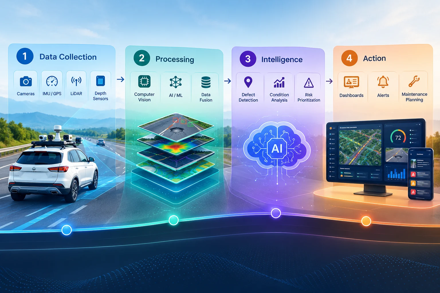
A single detection moving through a smart road monitoring system typically follows a consistent path: a camera captures a frame showing a road segment; computer vision flags a probable defect within that frame; sensor data (if available) confirms the finding by cross-referencing a corresponding vibration reading at the same GPS coordinate and timestamp; the intelligence layer classifies the defect type, scores its severity, and checks whether this location has previous detection history showing a worsening trend; if the finding crosses a defined severity or safety threshold, the system triggers an alert and automatically generates a work order; and the whole record image, classification, severity, location, timestamp, and resulting action is logged into a searchable, auditable database that also feeds into longer-term deterioration modeling. This entire sequence typically happens automatically, with no manual step required unless a human reviewer needs to confirm an ambiguous or high-stakes finding.
Core capabilities usually include pavement surface defects (potholes and the major crack types), rutting and surface roughness, and increasingly, broader road-adjacent conditions like signage visibility, drainage-related distress patterns, and right-of-way encroachment. More comprehensive systems extend tracking beyond simple detection into trend analysis flagging when a specific segment's deterioration rate is accelerating compared to similar segments elsewhere in the network, which is a genuinely predictive capability that pure detection tools don't offer.
Agencies sometimes evaluate road monitoring technology feature-by-feature does it detect potholes, does it have a dashboard, does it integrate with GIS without stepping back to ask whether these pieces actually function as one coherent system or as disconnected tools that happen to be sold together. A genuinely smart system is defined less by any individual capability and more by how tightly the four layers are integrated: whether a detection at Layer 1 flows cleanly through processing and intelligence all the way to action at Layer 4 without manual hand-offs breaking the chain along the way. A platform with excellent defect detection but no meaningful integration into maintenance workflows is still, functionally, just a reporting tool the intelligence exists, but it doesn't reliably turn into outcomes.
For agencies, a properly integrated system means findings don't sit in a dashboard waiting for someone to notice them they flow into action automatically, meaningfully shrinking the time between a defect appearing and a repair being dispatched. The intelligence layer's predictive capability supports genuinely proactive maintenance planning rather than reactive patching, since agencies can see which segments are trending toward failure before they actually fail. And because the entire pipeline from detection to action is logged and auditable, the system naturally produces the kind of consistent, timestamped documentation that supports budget justification, regulatory reporting, and liability defense.
A few patterns are worth watching for when evaluating vendors. Some platforms offer strong detection but weak intelligence they'll reliably spot a pothole but won't tell you whether it's part of a worsening trend or an isolated occurrence. Others have intelligence but poor integration genuinely useful predictions and prioritization that still require someone to manually create a work order in a separate system, reintroducing the delay the technology was supposed to eliminate. And some systems lean heavily on dashboards and visualizations without much underlying analytical depth, which can look impressive in a demo while delivering limited operational value once the novelty wears off.
As AI models and connectivity continue to mature, expect the four-layer architecture to become increasingly automated end-to-end edge devices handling more processing locally for faster response, intelligence layers incorporating richer predictive models trained on larger historical datasets, and action layers extending beyond simple work order generation toward more autonomous coordination, such as automatically flagging when a planned repair should be sequenced alongside nearby utility or drainage work. The broader trajectory is toward systems that require progressively less manual intervention at every layer, not just faster detection at the front end.
A smart road monitoring system is best understood as an integrated pipeline data collection, processing, intelligence, and action rather than any single feature or piece of hardware. The "smart" part isn't the camera or even the AI model doing defect detection; it's the degree to which a detection actually flows, without manual hand-offs, into a prioritized, contextualized, actionable outcome. Agencies evaluating this category should look past impressive individual capabilities and ask the more important question: does this system close the loop from detection to action, or does it stop short and leave that last, critical step to manual effort.
RoadVision AI is built as a complete system, not a single-feature tool connecting AI-powered detection, predictive intelligence, and direct maintenance workflow integration into one pipeline, so findings don't just sit in a dashboard, they turn into dispatched action.
Want to see the full detection-to-action pipeline in practice? Talk to the RoadVision AI team to learn more or request a demo.
It's an integrated platform that uses cameras, sensors, and AI to continuously observe road condition, interpret findings in context, and route them into maintenance action, rather than simply capturing and displaying raw data.
The intelligence layer prediction, severity scoring, and risk-based prioritization combined with direct integration into maintenance workflows, is what distinguishes a genuinely smart system from one that just automates data collection.
Most systems have four layers: data collection (cameras and sensors), processing (AI detection and sensor fusion), intelligence (prediction and prioritization), and action (dashboards, alerts, and work order integration).
Yes, the intelligence layer in a well-built system typically includes deterioration modeling, analyzing historical and current condition data to forecast how specific road segments are likely to decline over time.
Not necessarily. Many systems use standard fleet vehicles fitted with dashcams for data collection, alongside or instead of dedicated survey vehicles with specialized sensors.
By automatically routing high-severity or safety-critical detections directly into alerts and work order systems, closing the gap between detection and dispatched repair without requiring manual review at every step.

The Autonomous Road Engineer
AI-powered road condition monitoring, asset management, & infrastructure intelligence helping agencies move from reactive maintenance to predictive road management.


.webp)
.webp)
.webp)