
AI-based pavement distress detection uses computer vision to automatically identify and classify structural surface defects cracking, rutting, potholes, raveling from road imagery, typically processed after collection to build comprehensive condition data for maintenance planning. Real-time road hazard detection is a related but distinct capability: identifying dangerous conditions including but not limited to pavement distress as they're encountered, and triggering an immediate alert or response rather than waiting for scheduled analysis. The two overlap significantly (a newly formed pothole is both a pavement distress and a potential real-time hazard) but differ in urgency and scope: distress detection is about building accurate, comprehensive condition data over time; real-time hazard detection is about catching anything dangerous debris, flooding, stalled vehicles, severe potholes the moment it matters.
It's worth being clear about the relationship between these two terms, since they get used somewhat interchangeably in vendor marketing but actually describe different design priorities.
Pavement distress detection is fundamentally about classification accuracy and comprehensiveness. The goal is correctly identifying what type of structural defect exists fatigue cracking versus block cracking versus rutting and scoring its severity accurately enough to support standardized condition indices and long-term deterioration modeling. Processing speed matters, but it's not the defining constraint; a distress detection system that takes a day to fully process a week's worth of survey data is still delivering real value.
Real-time hazard detection is fundamentally about latency. The goal is identifying something dangerous fast enough that an alert actually arrives in time to matter before another vehicle hits the same hazard, before an emergency vehicle gets routed into a flooded underpass, before a stalled vehicle in a live lane causes a secondary collision. Classification precision matters here too, but speed is the defining constraint; a hazard detection system that takes a day to process data has essentially failed at its core job, regardless of how accurate its classification turns out to be.
A mature road safety technology stack generally needs both comprehensive distress detection for planning and maintenance, and real-time hazard detection layered on top for the subset of situations where speed is the difference between prevention and consequence.
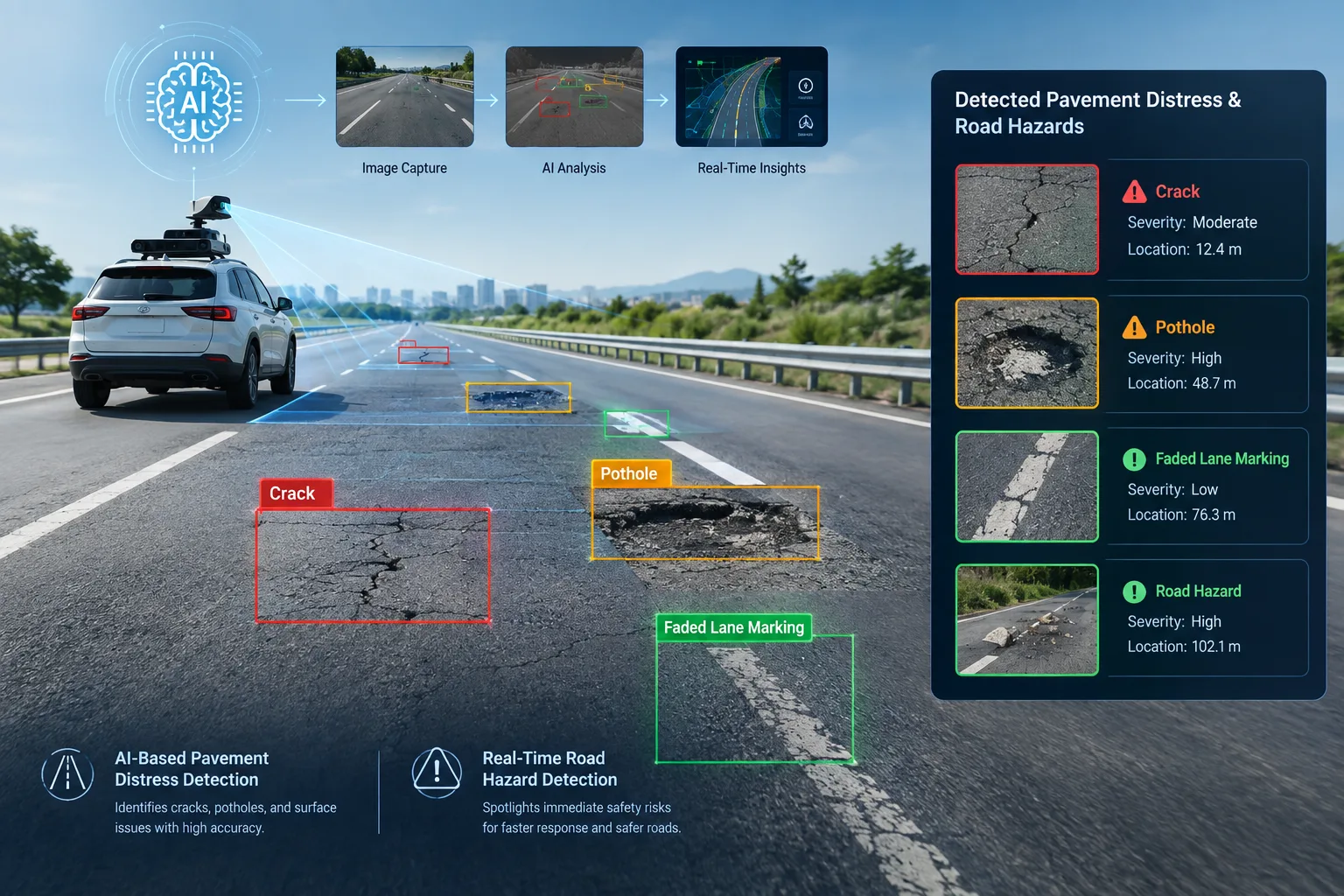
Vehicle-mounted cameras on dedicated survey vehicles, fleet vehicles with dashcams, or drones capture continuous imagery of the road surface as the vehicle travels its route.
Trained models, typically convolutional neural networks or object detection architectures like YOLO or Faster R-CNN, analyze captured frames to identify and classify distress types: fatigue (alligator) cracking, block cracking, edge cracking, transverse cracking, rutting, raveling, and potholes, each with a distinct visual signature the model has learned to recognize.
Where accelerometer or LiDAR data is available, it's cross-referenced against visual findings to confirm genuine physical distress and reduce false positives from shadows, staining, or surface discoloration.
Detected distress is scored based on size, depth, and density, typically mapped to standardized indices like the Pavement Condition Index so results integrate with established engineering and maintenance planning practice.
Because the same road segment is often surveyed multiple times over weeks, months, or years, distress detection systems consolidate and track findings over time, building the historical record that deterioration modeling and long-term capital planning depend on.
Rather than batch-processing collected footage after a survey run, real-time systems process imagery and sensor data as it's captured either on-device at the edge, or via low-latency streaming to nearby processing infrastructure, to minimize the delay between observation and alert.
Real-time detection typically covers a wider category of dangerous conditions than distress detection alone, including severe potholes and sudden pavement failures, debris or fallen objects in the roadway, standing water or flooding, stalled or crashed vehicles, downed trees or branches, and in some deployments, wildlife presence or extreme ice formation.
Because latency is the priority, real-time systems often use streamlined, optimized versions of detection models sometimes trading a small amount of classification precision for significantly faster processing, since a slightly less precise alert delivered in seconds is more valuable than a highly precise one delivered an hour later.
Once a hazard is confirmed, the system triggers an immediate alert to a traffic management center, a maintenance dispatch system, connected vehicle or navigation platforms, or in some deployments, directly to nearby digital signage warning approaching drivers.
Not every detected hazard warrants the same urgency; real-time systems typically apply severity-based triage so that a flooded underpass or stalled vehicle in a live lane triggers immediate escalation, while a minor, non-urgent finding is logged for routine follow-up rather than treated with the same urgency.
A severe, newly formed pothole illustrates the overlap well: it's simultaneously a pavement distress (relevant to long-term condition tracking and maintenance planning) and a potential real-time hazard (relevant to immediate driver safety, particularly at night or in wet conditions where it may not be visible until a driver is already upon it). A well-integrated system doesn't force a choice between these two framings it routes the same detection through both pathways simultaneously: logging it into the structured condition database for maintenance planning, while also triggering an immediate severity-based alert if the detected defect crosses a safety threshold.
Both systems share a common technical foundation computer vision models built on convolutional neural networks, object detection architectures, GPS geolocation, and increasingly, sensor fusion with accelerometer or LiDAR data for confirmation. Where they diverge technically is in processing architecture: distress detection systems can rely more heavily on cloud-based batch processing, since turnaround time of hours or days is acceptable, while real-time hazard detection depends much more heavily on edge computing processing directly on or near the vehicle or camera to avoid the latency that round-tripping data to a distant cloud server would introduce.
Distress detection delivers its value primarily through comprehensiveness and consistency: far greater network coverage than manual inspection within the same budget, objective classification criteria applied identically across every survey, and the kind of structured, historical data that genuinely supports deterioration modeling and multi-year capital planning rather than one-off condition snapshots.
Real-time detection delivers its value through speed: catching dangerous conditions within minutes rather than waiting for the next scheduled inspection or a citizen complaint, enabling faster emergency response coordination for severe hazards like flooding or crashes, and in connected deployments, warning approaching drivers directly before they encounter a hazard they couldn't otherwise anticipate.
Pavement distress detection's main challenges center on classification accuracy across diverse weather, lighting, and road surface conditions, and ensuring output remains compatible with established engineering indices and standards. Real-time hazard detection's main challenges center on latency and infrastructure maintaining reliable connectivity for timely alert delivery, managing the computational demands of edge processing, and avoiding alert fatigue from false positives, which is a more acute risk for real-time systems than for batch-processed distress detection, since every false alert consumes immediate, high-priority attention from whoever receives it.
For pavement distress detection, prioritize documented classification accuracy across multiple distress types and conditions relevant to your network, and compatibility with standardized condition indices like PCI. For real-time hazard detection, prioritize documented end-to-end latency (from detection to alert delivery, not just model inference speed), reliable alert routing to the right response systems, and a demonstrated approach to minimizing false positives without sacrificing genuine hazard sensitivity. If you need both which most comprehensive road safety programs eventually do confirm whether a single platform genuinely supports both use cases well, or whether you'll need separate, integrated systems to cover each effectively.
AI-based pavement distress detection and real-time road hazard detection solve related but distinct problems: one builds the comprehensive, structured condition data that long-term maintenance planning depends on, and the other catches dangerous conditions fast enough for the detection to actually prevent harm rather than just document it after the fact. Both rely on the same underlying computer vision foundation, but they're optimized for different priorities classification depth and consistency for distress detection, raw speed for hazard detection and a genuinely comprehensive road safety and maintenance program needs both working together rather than treating either as a complete solution on its own.
RoadVision AI combines comprehensive AI-based pavement distress classification with real-time hazard detection in a single pipeline so the same system building your long-term condition data also catches and alerts on dangerous conditions the moment they matter.
Want to see both capabilities working together on your network? Talk to the RoadVision AI team to learn more or request a demo.
It's the use of computer vision to automatically identify and classify structural road surface defects such as cracking, rutting, and potholes from imagery, supporting standardized condition scoring and long-term maintenance planning.
Real-time road hazard detection identifies dangerous road conditions including pavement failures, debris, flooding, or stalled vehicles as they occur, triggering immediate alerts rather than waiting for scheduled data processing.
Distress detection prioritizes classification accuracy and comprehensive condition tracking over time, while hazard detection prioritizes speed, aiming to deliver alerts within minutes so dangerous conditions can be addressed before they cause harm.
Yes, well-integrated platforms can route the same detections through both pathways logging findings into structured condition data while also triggering immediate alerts for anything crossing a safety severity threshold.
Real-time detection relies heavily on edge computing processing data directly on or near the vehicle or camera to minimize the latency that cloud-based batch processing would otherwise introduce.

The Autonomous Road Engineer
AI-powered road condition monitoring, asset management, & infrastructure intelligence helping agencies move from reactive maintenance to predictive road management.


.webp)
.webp)
.webp)