
This is a project-level account from RoadVision AI's road survey programme for NHAI's Kolkata Regional Office, covering the four-laned Kolaghat–Haldia section of NH-116 (formerly NH-41) in West Bengal, from Km 0.00 to Km 53.72, including the ROB cum flyover from Km 52.08 to Km 53.472. It sets out why a port-access corridor like this one warrants continuous monitoring, and what the survey record shows so far.
The Kolaghat–Haldia section of NH-116 links Kolaghat, where it meets the major NH-16 artery, directly to the Haldia Port industrial zone. It spans 53.72 km, was developed as a four-lane highway on an EPC basis, and falls under NHAI's Kolkata Regional Office.
Its most significant structure is the ROB cum flyover at Ranichak, Haldia, running 1.392 km from Km 52.08 to Km 53.472. It was provided to remove a major bottleneck at the port approach, where intersecting railway lines and heavy commercial truck traffic had been choking the road. Operations and maintenance on the corridor are reported to run under public-private frameworks such as OMT.
Every finding sits on a live GIS map, with each inspection point opening to its exact location, the defect flagged, and the frame behind it in both original and AI-annotated form. Figure 1 shows the corridor as it runs toward the Haldia sub-district, filtered here to daytime survey passes on the right-hand side of the carriageway. The inspection point flags general encroachment beside the road and faded pavement marking, with a tanker truck in the frame exactly the heavy commercial traffic the corridor exists to carry.
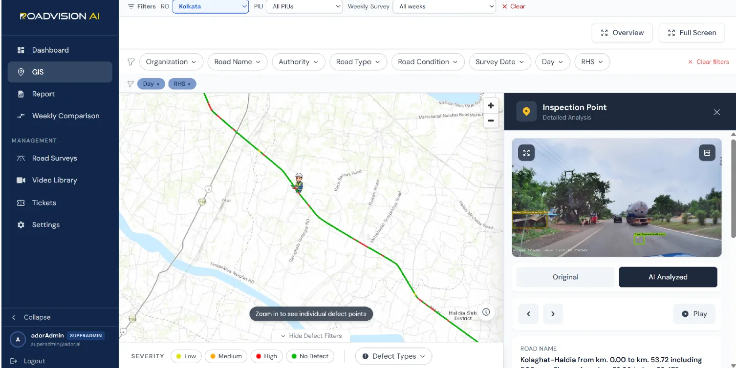
A road carrying port-bound freight wears differently from one carrying mixed local traffic: loads are heavier, traffic is steadier through the day, and a defect that stays unaddressed has an immediate cost in delays at the port gate. The roadside tells the same story, as encroachment next to the carriageway shows even in a single inspection frame. A site visit can confirm condition on the day it is made; it cannot show whether a fixed defect has stayed fixed, or whether a new one has opened up since. Over 53.72 km, only a repeatable survey, tied to precise chainage, can keep that picture current.
In Survey 5, RoadVision AI covered 53.59 km of the corridor in 535 segments at a 100 m chainage interval. The per-segment distribution shows where findings sit along the road. In the first 6.6 km of the chart, findings begin around the 200 m mark and appear in most segments from there on, typically one to six per 100 m. The heaviest single segment, around 1.8 to 1.9 km, carries nine findings, with a second cluster peaking at seven near 2.3 to 2.4 km. Beyond about 3 km the counts thin out, mostly to one to three findings per segment.
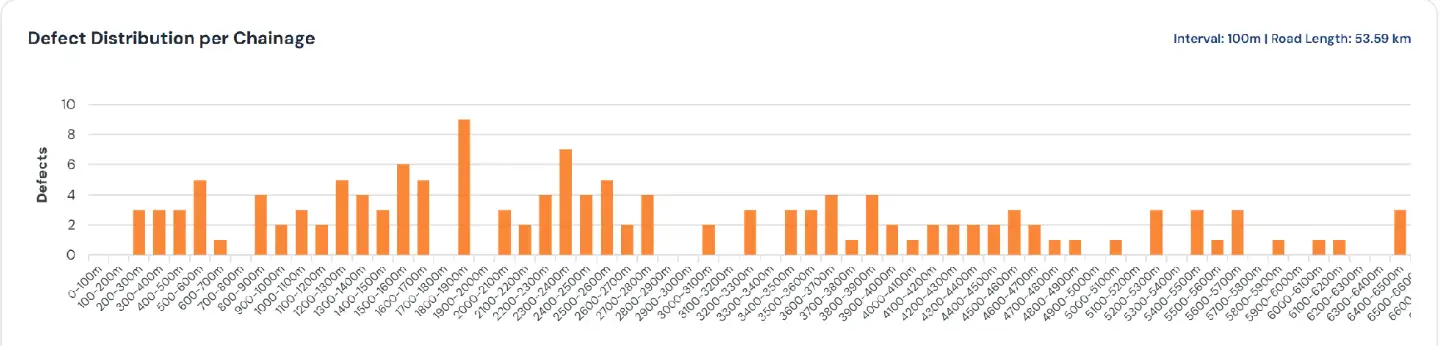
Because every finding carries a unique ID and a chainage, the same segments can be checked in the next survey. A cluster like the one near 1.8 to 1.9 km is exactly the kind of location that can be revisited to confirm whether remedial work has held.
Each survey report gives the Kolkata RO a defect ID, chainage and survey reference for every finding, independent of the agency responsible for maintaining the road. A later survey of the same chainage then shows whether the finding has been closed out, so that verification does not rest on the maintaining agency's own account.
RoadVision AI is committed to continuous AI-based road condition monitoring of the Kolaghat–Haldia corridor, including the Ranichak ROB cum flyover, and to giving NHAI a consistent, chainage-level record of its condition. A road that carries a port's freight has little tolerance for unaddressed defects. Keeping verification current, survey after survey, is central to keeping this corridor moving safely.

The Autonomous Road Engineer
AI-powered road condition monitoring, asset management, & infrastructure intelligence helping agencies move from reactive maintenance to predictive road management.


.webp)
.webp)
.webp)