There is a moment every driver knows that sudden, jarring impact, the instinctive wince, the mental calculation of whether something just broke underneath the car. Potholes are one of the most universally frustrating features of modern road infrastructure, and yet for all the complaints they generate, the systems most cities and highway authorities use to find and fix them have changed remarkably little in the past century.
A worker drives a route. A worker spots a hole. A worker files a report. A crew comes out days, weeks, or sometimes months later to fill it.
In the meantime, that pothole has swallowed dozens of tires, bent rims, damaged suspensions, and in worst-case scenarios, caused accidents. It has also grown. Every vehicle that strikes an unrepaired pothole widens and deepens it, accelerating the deterioration of surrounding pavement and compounding the repair cost with each passing day.
The American Society of Civil Engineers estimates that poor road conditions cost U.S. drivers alone over $130 billion annually in vehicle damage and operating costs. In Canada, the figure exceeds $3 billion per year. Globally, the number is staggering and the root cause is consistently the same: road defects are found too late, prioritized inconsistently, and repaired reactively rather than proactively.
Pothole detection AI is rewriting that story. By deploying computer vision, deep learning, and real-time data systems on the roads themselves, RoadVision AI is enabling road authorities to find what human inspectors routinely miss earlier, faster, and at a fraction of the traditional cost.
Before examining what AI does differently, it is worth understanding precisely where human-led pothole inspection falls short because the failures are systematic, not merely a matter of effort or attention.
Coverage is fundamentally limited. A manual inspection crew can realistically survey 50 to 80 kilometres of road per day under good conditions. A mid-sized city may have 3,000 kilometres of road network. Completing a single full inspection cycle takes weeks and by the time the crew returns to the start, conditions have changed significantly, especially during winter and spring thaw.
Consistency is impossible to guarantee. Human inspectors apply judgment, and judgment varies by individual, fatigue level, lighting conditions, and weather. A crack that one inspector rates as urgent may be logged as moderate by another. This inconsistency makes it extremely difficult to compare condition data across time or across different sections of a network.
Early-stage defects are routinely missed. The surface cracks, micro-fractures, and pavement depressions that precede pothole formation are often invisible to the naked eye or simply not recognized as significant by inspectors without specialist training. By the time a defect is large enough for reliable visual detection, the pavement structure beneath it has already failed.
Reactive bias is baked into the system. Most municipal pothole reporting systems are complaint-driven. A pothole gets fixed when enough residents call. Roads in lower-traffic or lower-income areas generate fewer complaints, creating inequitable maintenance outcomes that have nothing to do with actual pavement condition.
AI-powered pothole detection does not eliminate human judgment it extends human capability far beyond what any team of inspectors working with clipboards and cameras could achieve.
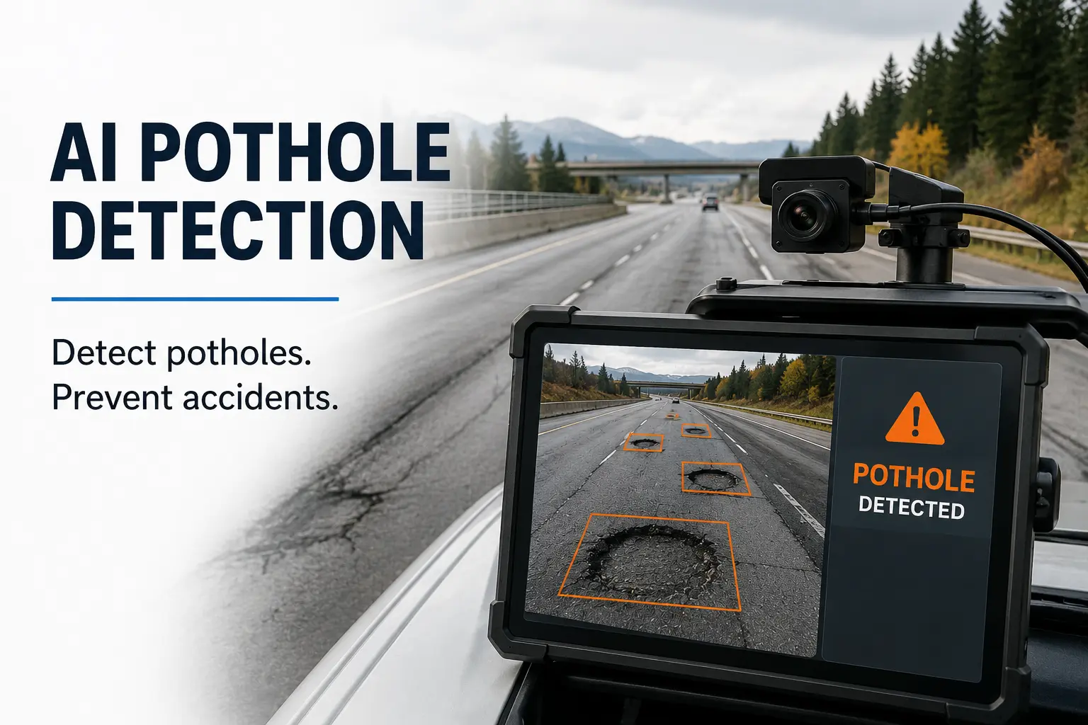
Pothole detection AI is the application of artificial intelligence specifically computer vision and deep learning to the automated identification, classification, measurement, and prioritization of road surface defects including potholes, cracks, rutting, ravelling, and subsidence.
At its core, the technology trains neural network models on large annotated datasets of road condition imagery, teaching the system to recognize the visual and geometric signatures of different defect types across a wide range of environmental conditions. Once trained, these models can process live or recorded video and sensor data at speeds and scales completely beyond human capability.
Modern pothole detection AI systems incorporate several complementary technologies:
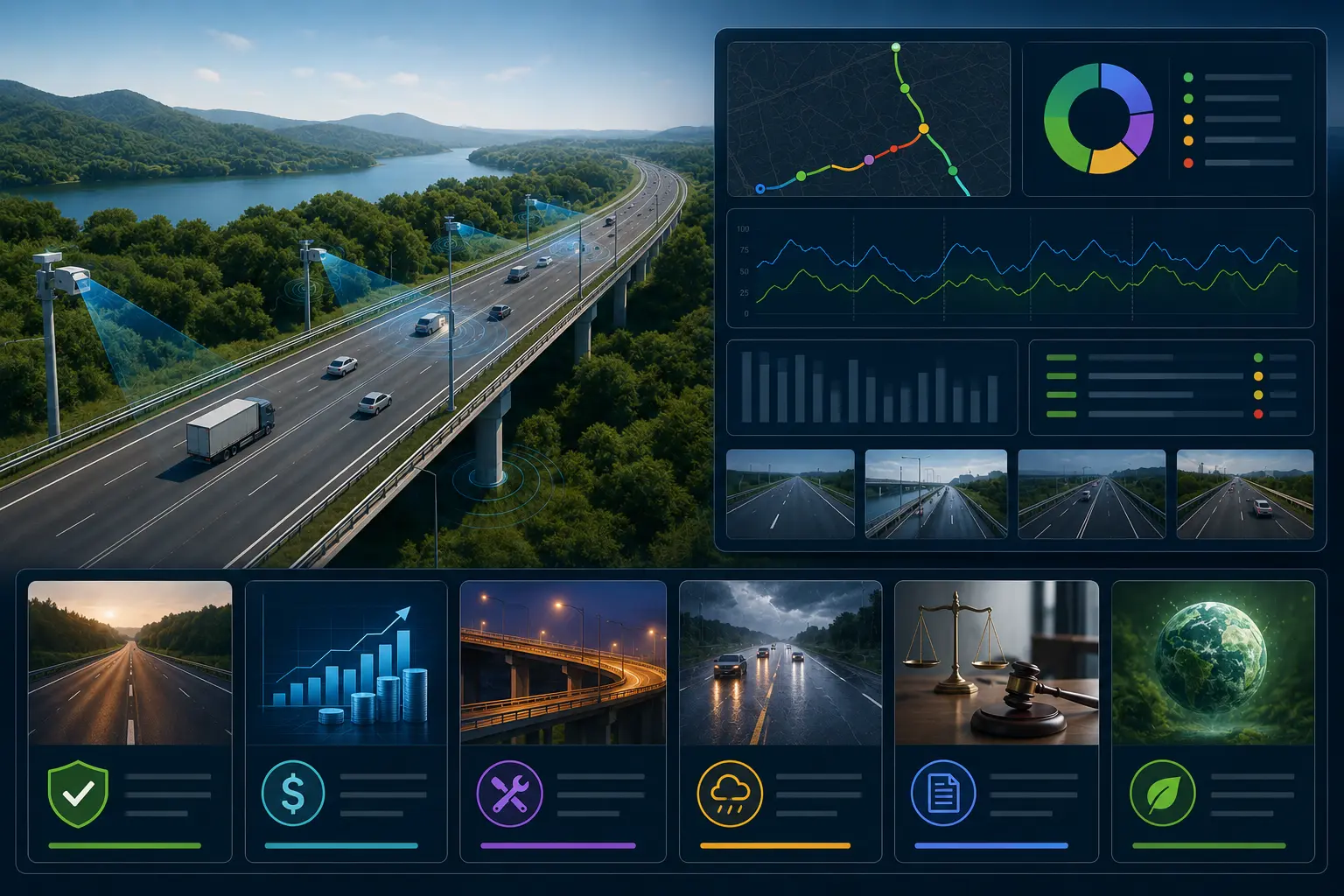
RoadVision AI's platform integrates all of these technologies into a unified system specifically engineered for real-world road inspection environments.
RoadVision AI's sensor suite mounts to any road maintenance vehicle, patrol truck, or fleet asset transforming vehicles already operating on the network into rolling inspection platforms. As these vehicles travel their regular routes, the system continuously captures synchronized high-resolution imagery, LiDAR scans, and IMU data across every metre of road surface traversed.
This embedded approach means AI road inspection happens continuously as a by-product of normal operations not as a separate, expensive, scheduled activity. Road networks can be assessed on weekly or even daily cycles rather than quarterly, giving road authorities a genuinely current picture of network condition at all times.
Raw sensor data is processed immediately by RoadVision AI's multi-model detection engine, running on edge computing hardware mounted in the vehicle. Separate specialized models handle different defect categories:
A surface crack detection model identifies longitudinal, transverse, and alligator cracking patterns that signal pavement condition fatigue and impending pothole formation. A pothole geometry model uses LiDAR point cloud data to measure depth, area, and volume for detected potholes. A roughness index model processes IMU data to generate International Roughness Index (IRI) scores for each road segment continuously.
Each detected defect is assigned a defect type, a severity classification, and a confidence score giving operators clear, consistent data rather than subjective field notes.
Every detection is automatically tagged with precise GPS coordinates and plotted on RoadVision AI's live GIS map interface. Operators see a continuously updated visual inventory of network defects color-coded by severity, filterable by defect type, and searchable by road name, roadside asset class, or geographic area.
Unlike static inspection reports that are outdated the moment they are printed, RoadVision AI's map is a living document that reflects actual current conditions. New detections appear within minutes of a vehicle completing a pass. Repaired defects can be marked closed and removed from the active priority queue.
Detecting potholes that already exist is valuable. Predicting where the next potholes will form is transformative. RoadVision AI's predictive deterioration module analyzes current pavement condition scores alongside historical degradation rates, seasonal weather forecasts, traffic loading estimates, and subgrade drainage data to model how each road segment's condition will evolve over the coming weeks and months.
This forward-looking capability enables road authorities to schedule pre-emptive crack sealing and surface treatments at the moment of maximum cost-effectiveness typically when a crack is between 3 and 8 millimetres wide rather than waiting until full pothole formation requires far more expensive patching or reconstruction.
RoadVision AI's platform integrates directly with maintenance management systems to auto-generate work orders for detected defects, ranked by a composite priority score that weighs defect severity, traffic volume on the affected road, proximity to critical infrastructure, and predicted deterioration trajectory. Maintenance crews receive a clear, data-driven repair queue rather than an undifferentiated list of complaints and field reports.
This prioritization capability is especially powerful for road authorities managing networks larger than their annual maintenance budget can fully address it ensures that every maintenance dollar is directed to the repair with the greatest safety and economic return.
The performance gap between AI-powered and human inspection is not marginal it is fundamental. Here is specifically what computer vision detects that human inspectors consistently miss:
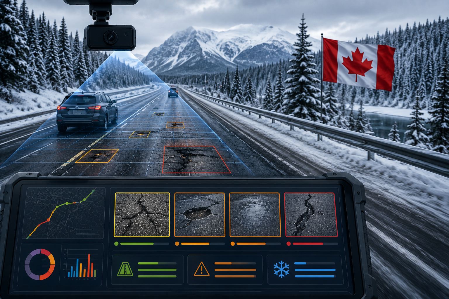
Sub-millimetre surface cracking. RoadVision AI's high-resolution cameras and image processing pipeline can detect surface cracks as narrow as 0.5 millimetres — far below the threshold of reliable human visual detection, particularly from a moving vehicle. These hairline cracks are the earliest warning signs of pavement fatigue and the ideal intervention point for low-cost preventive sealing.
Subsurface deformation. LiDAR-derived 3D surface models reveal pavement depressions, wheel path rutting, and frost heave displacement of just a few millimetres — invisible to visual inspection but measurable indicators of structural distress developing beneath the surface.
Night and low-light defects. Human inspection is practically impossible after dark and severely degraded in overcast winter light. RoadVision AI's near-infrared camera channels and LiDAR scanning are unaffected by ambient lighting enabling 24-hour inspection capability that captures the full distribution of network usage conditions.
Defects obscured by surface water or debris. Standing water in a pothole hides its true depth from visual assessment. LiDAR penetrates water surfaces and accurately measures pothole geometry regardless of whether the defect is dry, wet, or partially filled with debris.
Pattern-level deterioration. An individual human inspector evaluating a 500-metre road section cannot simultaneously recognize that the cracking pattern on this stretch matches the early-stage signature of a pavement base failure they observed on a similar road section two years ago. RoadVision AI's models, trained on thousands of such examples, recognize these patterns automatically and flag them for engineering review.
Urban Municipal Road Networks: City public works departments managing thousands of kilometres of local roads with constrained budgets benefit enormously from AI-assisted prioritization. RoadVision AI enables comprehensive annual network assessments, eliminating the complaint-driven bias of traditional reactive systems and ensuring equitable, condition-based maintenance allocation across all city neighborhoods.
Provincial and State Highways: High-speed highway environments create particular safety risks from pothole formation a pothole that would be a nuisance at 50 km/h becomes a genuine accident hazard at 110 km/h. RoadVision AI's continuous monitoring of provincial highway corridors ensures that high-severity defects are identified and work-ordered within days of formation rather than discovered after an incident.
Airport Runways and Taxiways: Aviation pavement maintenance standards are among the most rigorous in the world, and even minor surface defects can compromise aircraft safety. RoadVision AI's precision surface scanning delivers the sub-millimetre accuracy required for airfield pavement condition assessment, far exceeding the capability of traditional manual inspection methods.
Port and Logistics Facility Roads: Heavy vehicle terminals, container ports, and logistics parks subject their internal road networks to extreme loading. Pothole formation in these environments accelerates rapidly and damages high-value cargo vehicles. RoadVision AI enables facilities managers to maintain continuous condition inventories and plan preventive maintenance around operational constraints.
Utility and Resource Roads: Remote resource roads serving mining, forestry, and energy extraction operations are typically unpaved or low-specification paved surfaces subject to heavy industrial traffic. Pothole formation and road surface failure in these environments carries serious safety and operational continuity risks. RoadVision AI's offline-capable edge processing allows inspection data collection in areas without cellular connectivity.
The economics of AI-powered pothole detection are compelling and straightforward. Road infrastructure follows a well-documented deterioration cost curve the earlier a defect is addressed, the lower the unit cost of repair.
Sealing a 3-millimetre surface crack costs approximately $2 to $5 per linear metre. Patching the pothole that forms from that unsealed crack costs $50 to $150 per square metre. Reconstructing the road section that fails after the pothole damages the base course costs $500 to $1,500 per square metre. The cost ratio between early prevention and full reconstruction is routinely 100:1 or greater.
RoadVision AI customers consistently report maintenance cost savings of 35 to 55% within the first two to three years of deployment, driven primarily by the shift from reactive patching to proactive preservation. When factored against reduced liability exposure from vehicle damage claims and accident litigation, the financial case for AI-powered pothole detection becomes overwhelming.
RoadVision AI was not built as a generic computer vision platform adapted for roads it was engineered from the outset as a road condition intelligence system, by a team with deep domain expertise in transportation infrastructure. Our detection models are trained specifically on pavement condition data from North American road networks, including the harsh climate environments of Canada and the northern United States, where seasonal extremes stress both the roads and the inspection systems trying to monitor them.
We work directly with municipal engineers, provincial highway authorities, and private infrastructure operators to configure deployments that fit their existing vehicle fleets, maintenance workflows, and asset management platforms. Our implementation approach prioritizes rapid time-to-value most customers are collecting AI-powered inspection data within days of sensor installation, not months.
Every RoadVision AI deployment includes ongoing model refinement as our system learns from the specific defect patterns of your network, continuously improving detection accuracy over time.
Potholes have been a fact of road life for as long as there have been roads but the inability to find them quickly, measure them accurately, and fix them before they become serious hazards is not inevitable. It is the result of inspection systems that have not kept pace with the scale and complexity of modern road networks.
RoadVision AI's pothole detection AI changes the equation fundamentally. By deploying computer vision and deep learning on the roads themselves, road authorities gain a continuously updated, precisely measured, and intelligently prioritized picture of network condition that no manual inspection program could match in speed, coverage, or consistency.
The result is roads that are safer, infrastructure budgets that go further, and a maintenance system that finally finds the problems before drivers find them the hard way.
Ready to see what your road network looks like through the eyes of AI? Contact RoadVision AI today to book a demonstration or start a pilot program on your network.
RoadVision AI's detection system achieves over 94% accuracy in pothole identification across standard road conditions, and outperforms manual inspection in low-light, high-speed, and early-stage defect detection scenarios. Independent validation studies consistently show AI systems detecting 30 to 50% more defects per network kilometre than equivalent manual survey programs.
In addition to potholes, RoadVision AI detects longitudinal and transverse cracking, alligator cracking, edge deterioration, rutting, ravelling, surface deformation, frost heave, subsidence, and drainage failures. Each defect type is classified separately and assigned an independent severity rating.
Yes. RoadVision AI's models include variants trained on unsealed road surfaces, making the platform suitable for gravel resource roads, rural municipal roads, and unpaved park or utility corridors. Detection categories adapt to the relevant defect types for unpaved surfaces, including washboarding, soft spots, erosion channels, and surface aggregate loss.
The platform uses a multi-sensor approach specifically to maintain reliability under adverse conditions. LiDAR and IMU sensors continue to function reliably regardless of rain, fog, or low light. Optical imagery captured under degraded conditions is automatically flagged for confidence scoring, and operators are alerted when atmospheric conditions may have reduced detection completeness for a given road pass.
Yes. RoadVision AI supports export in GeoJSON, Shapefile, CSV, and IFC formats, and offers direct API integration with major asset management systems including IBM Maximo, Cityworks, Cartegraph, and custom platforms. Our integration team works with clients to ensure seamless data flow into existing maintenance workflows.

The Autonomous Road Engineer
AI that is transforming road infrastructure, from reactive to predictive.
.webp)