The United States has the largest road network in the world more than 4 million miles of public roads connecting cities, suburbs, rural communities, ports, and industrial centers across fifty states. This network is the backbone of the American economy, handling over 11 billion vehicle miles traveled every single day.
It is also, by almost every available measure, in serious trouble.
The Federal Highway Administration (FHWA) reports that nearly 40% of U.S. roads are in poor or mediocre condition. Aging infrastructure built in the mid-twentieth century designed for traffic volumes and vehicle weights a fraction of today's is deteriorating under demand it was never engineered to sustain. The American Society of Civil Engineers gives America's roads a D+ in its Infrastructure Report Card, estimating that the cost of driving on roads in need of repair amounts to $1,000 per driver per year in vehicle operating costs.
The federal response has been significant. The Infrastructure Investment and Jobs Act of 2021 directed $110 billion toward roads and bridges, the single largest federal investment in surface transportation in generations. Regulatory frameworks from the Federal Highway Administration and engineering standards from the American Association of State Highway and Transportation Officials are more comprehensive and data-driven than at any point in history.
And yet the fundamental monitoring problem knowing the actual, current condition of a network spanning millions of miles with the timeliness and accuracy that modern asset management demands remains largely unsolved by the inspection and reporting systems most state DOTs and local agencies actually operate.
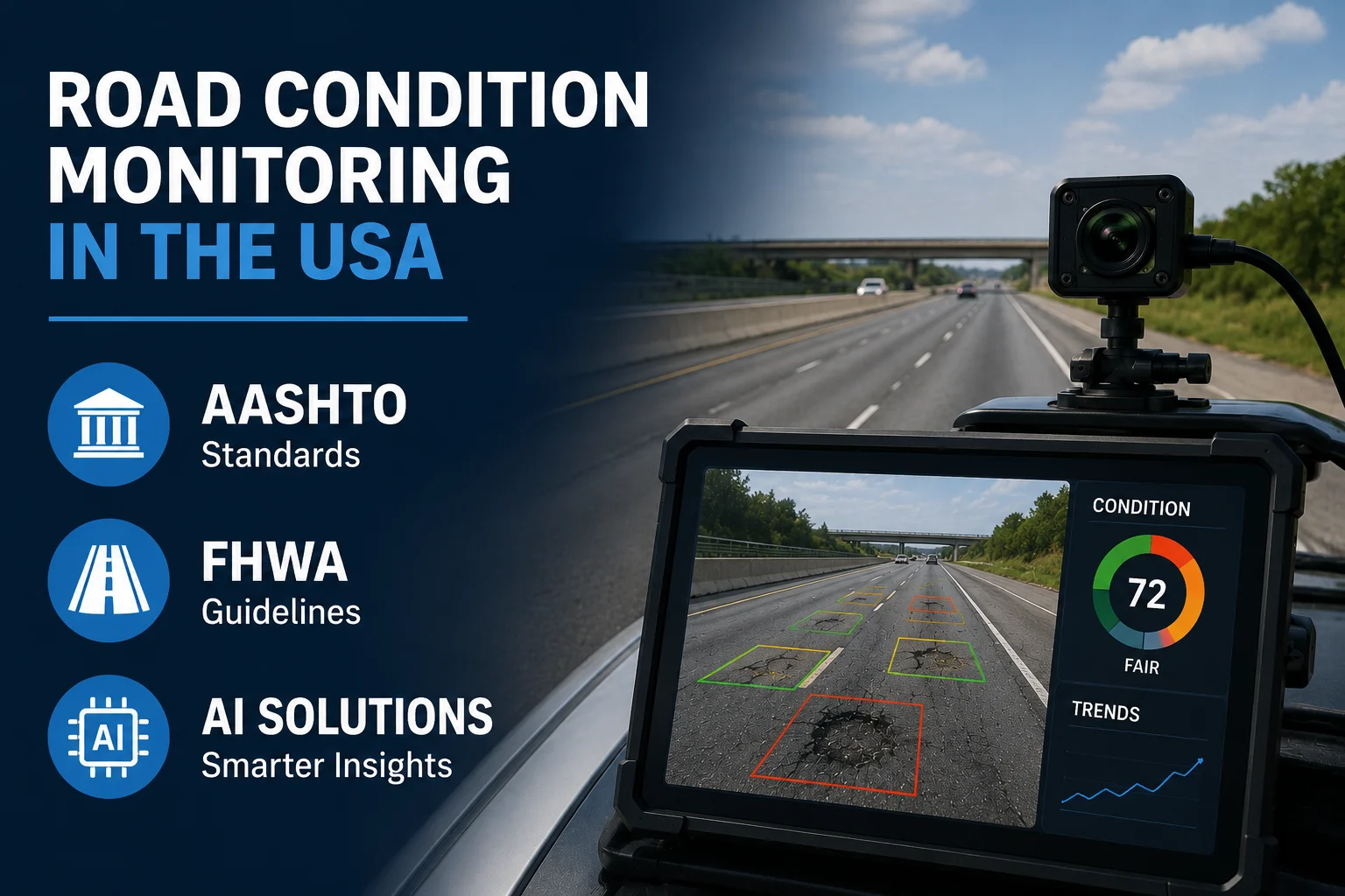
This is where AI enters the picture. RoadVision AI's autonomous road engineering platform, aligned to AASHTO, FHWA, and ASTM standards, is helping U.S. agencies move from the reactive, cyclical monitoring model that has defined road management for decades toward continuous, predictive intelligence at the scale America's network demands.
Understanding why road condition monitoring in the U.S. is structured the way it is requires understanding the regulatory and standards architecture within which every state DOT, metropolitan planning organization, and local road agency must operate.
The Federal Highway Administration is the federal agency within the U.S. Department of Transportation primarily responsible for supporting state and local governments in the design, construction, and maintenance of the highway network. FHWA's role in road condition monitoring operates on several levels simultaneously.
One of FHWA's most important responsibilities is establishing national guidance for roadway design and traffic control. These standards ensure consistency across states and support evidence-based safety decisions.
FHWA's primary tool for national road condition data collection and reporting is the Highway Performance Monitoring System (HPMS) — a congressionally mandated database into which all state DOTs must report pavement condition, traffic volume, and other roadway characteristics annually. HPMS data feeds directly into federal funding allocation decisions, national infrastructure reports, and long-term transportation planning at the federal level.
Key FHWA monitoring mandates relevant to pavement condition include the International Roughness Index (IRI) for ride quality assessment, Present Serviceability Rating (PSR), rutting depth measurement, cracking percentage, and faulting for jointed concrete pavements. States must report these metrics annually on the National Highway System and are increasingly expected to deploy automated or semi-automated data collection systems to meet FHWA's quality and accuracy requirements.
FHWA also promotes technology adoption through ITS programs, connected infrastructure research, digital inspection tools, and vehicle-to-infrastructure (V2I) advancements supported by AI-powered monitoring systems.
The American Association of State Highway and Transportation Officials AASHTO is the membership organization of state transportation departments that develops and maintains the engineering standards, guides, and specifications that govern highway design, construction, and maintenance across the United States. Where FHWA sets federal policy and funding conditions, AASHTO provides the engineering methodology.
For road condition monitoring specifically, AASHTO's contributions span pavement design guides, materials testing standards, pavement management system guidelines, and road safety audit standards the latter aligned with WHO road safety benchmarks. AASHTO's Pavement Management Guide establishes the framework within which state DOTs develop their own pavement management programs, defining condition indices, treatment selection logic, and performance prediction methodologies.
AASHTO standards are not legally binding in the way federal regulations are, but their adoption is so widespread across U.S. state DOTs that they function as de facto national engineering standards for highway infrastructure. Although the U.S. follows FHWA and AASHTO standards, global best practices especially from the Indian Roads Congress (IRC) offer additional structured approaches that complement U.S. guidelines.</c
Alongside FHWA and AASHTO, ASTM International provides foundational test methods and standards for pavement condition assessment. ASTM D6433 — the Standard Practice for Roads and Parking Lots Pavement Condition Index Survey is the basis for the Pavement Condition Index (PCI), the most widely used condition metric in U.S. road management, applied from municipal street networks to the National Highway System.
All U.S. states must have access to MIRE Fundamental Data Elements on public roads by September 30, 2026, per FHWA regulations./cit The Model Inventory of Roadway Elements (MIRE) 2.1 is FHWA's standardized framework specifying which roadway and traffic data elements must be collected and maintained across the public road network covering roadway geometry, traffic control devices, crash data linkages, and pavement characteristics.
MIRE 2.1 compliance requires road agencies to maintain far more comprehensive, accurate, and current roadway attribute data than most have traditionally managed. <cite index="7-1">Many municipalities and even state DOTs lack the staff or budget for large-scale manual surveys covering thousands of miles annually, and MIRE demands highly accurate location data for roadway elements, which traditional GPS-based methods often fail to deliver at the required precision.</cite>
The standards framework described above is sophisticated and well-developed. The gap is not in standards — it is in the monitoring systems that most agencies rely on to actually collect, process, and act on road condition data against those standards.
The HPMS reporting burden is significant and manually intensive. State DOTs must report pavement condition data for tens of thousands of miles of National Highway System roads annually, and while FHWA has encouraged the adoption of automated pavement condition data collection vehicles over the past decade, many agencies particularly smaller states and local road authorities still rely on labor-intensive windshield surveys and manual data entry for a significant portion of their network. The result is condition data that is annual at best, covering only a sample of the network, and subject to the inter-rater inconsistency inherent in manual assessment.
Local roads are effectively unmonitored. HPMS requirements focus on the National Highway System and other federal-aid-eligible roads — a fraction of the total 4-million-mile U.S. network. The vast majority of local roads, which carry the most vehicle trips and the most vulnerable road users, have no federal monitoring requirement and no standardized condition data program. <cite index="2-1">Networks grow faster than teams can scale. Conditions change daily; inspections happen quarterly. $10,000 interventions become $100,000 emergency repairs.</cite>
MIRE 2.1 compliance is creating a data collection crisis. The scope of MIRE 2.1's Fundamental Data Elements requires agencies to collect and maintain detailed attributes lane widths, surface type, median type, shoulder characteristics, traffic control device inventory, and much more across the entire public road network. Older Linear Referencing Systems (LRS) and fragmented GIS platforms often struggle to align with the detailed MIRE schema, creating data silos and inconsistency. Traditional manual survey methods cannot deliver the accuracy, coverage, and update frequency MIRE requires within realistic budget constraints.
Safety data requirements are intensifying. FHWA's Highway Safety Improvement Program (HSIP) requires states to submit data-driven safety plans and demonstrate systematic application of countermeasures at high-risk locations. Strategic Highway Safety Plans (SHSPs) must be grounded in location-specific, roadway-feature-level data exactly the kind of continuous, spatially precise condition monitoring that traditional inspection processes struggle to deliver.
This is the point at which RoadVision AI's platform addresses the U.S. regulatory environment directly — not as a generic AI product applied to roads, but as a standards-aware system built to produce outputs that map onto FHWA, AASHTO, ASTM, and MIRE frameworks.
RoadVision AI's Pavement Condition Intelligence Agent is validated against professional inspector assessments and aligned with ASTM D6433, AASHTO, and IRC standards for pavement evaluation. The models achieve over 94% consistency with certified manual inspections.
This alignment matters directly for HPMS compliance. When a state DOT or local agency uses RoadVision AI's platform to generate PCI scores, IRI proxies, and distress inventory data, those outputs are produced against the same ASTM D6433 methodology that FHWA recognizes as the basis for pavement condition reporting meaning AI-generated condition data can flow directly into HPMS submissions and asset management planning without requiring translation or manual re-interpretation.
<cite index="5-1">Any standard dashcam or vehicle-mounted camera system with GPS and timestamp data works perfectly with the platform</cite> — meaning agencies do not need to invest in expensive dedicated survey vehicles to achieve ASTM-aligned pavement condition data. Maintenance trucks, patrol vehicles, and fleet assets already covering the network can serve as the data collection platform, dramatically reducing the per-kilometre cost of comprehensive condition surveying.
For U.S. applications, this means AASHTO-aligned safety assessments that map directly to the HSIP data requirements FHWA mandates for federal-aid safety funding. By detecting potholes, cracking, surface deterioration, and unsafe roadway conditions early, agencies can shift from reactive repairs to predictive risk management supporting federal Vision Zero goals and HSIP requirements for data-driven safety improvements.</cite>
The platform supports configurable outputs mapped to specific state requirements while maintaining core consistency with FHWA guidance< an important practical capability given that state DOTs operate within FHWA's federal framework while maintaining state-specific standards and reporting formats.
RoadVision AI provides compliance-ready reporting for FHWA and HSIP submissions, seamless integration with traffic, crash, and GIS systems, and continuous monitoring that keeps datasets current without recurring survey costs.
For agencies facing the September 2026 MIRE 2.1 compliance deadline, this is a direct operational answer. The Roadside Assets Inventory Agent automatically detects and geo-tags traffic control devices, signs, barriers, and roadway features — exactly the categories of Fundamental Data Elements MIRE requires at the scale and accuracy that manual survey programs cannot realistically deliver within budget and timeline constraInteractive dashboards mirror MIRE categories, simplifying reporting and compliance checks for FHWA submissions and HSIP grant applications.
RoadVision AI's Blackspot Analysis Agent identifies accident-prone zones by correlating crash history with road condition, geometry, and asset inventory data producing location-specific safety priority rankings and recommended countermeasures. This directly supports the data-driven blackspot identification and treatment selection processes that FHWA requires for HSIP expenditure justification and SHSP development.
By analyzing where and why crashes occur, agencies can target high-risk locations and apply the most effective countermeasures. AI-based infrastructure analytics further enhance proactive maintenance strategies.
RoadVision AI's approach to road condition monitoring follows a structured pipeline applicable directly to U.S. agency workflows:
Collect — Multi-source data ingestion from dashcams already deployed on state and local fleet vehicles, supplemented by drone and satellite imagery for areas with lower vehicle coverage. No dedicated survey fleet required.
Process — RoadGPT, RoadVision AI's AI-powered pavement management system, analyzes incoming data against 50+ standards including ASTM, AASHTO, and IRC. Every finding is traceable to a specific standard, ensuring regulatory defensibility.
Execute — Specialist agents perform targeted analysis: the Pavement Condition Intelligence Agent for HPMS-relevant pavement metrics, the Roadside Assets Inventory Agent for MIRE 2.1 Fundamental Data Elements, the Road Safety Audit Agent for HSIP-aligned safety assessment, and the Blackspot Analysis Agent for SHSP priority locations.
Deliver — Actionable insights delivered through interactive dashboards, detailed reports, and developer-ready APIs that integrate with the state DOT RAMS, GIS platforms, and HPMS reporting tools agencies already operate not a parallel system requiring duplicate data entry.
State Departments of Transportation State DOTs managing thousands of miles of NHS and non-NHS roads use RoadVision AI to maintain current pavement condition inventories for HPMS reporting, generate AASHTO-aligned safety audit documentation for HSIP submissions, build MIRE 2.1-compliant roadway feature inventories, and identify high-risk corridors for SHSP targeting all from data captured by fleet vehicles already traveling the network.
Metropolitan Planning Organizations MPOs responsible for long-range transportation planning in urban areas use AI-generated condition and safety data to strengthen the evidence base for capital investment priorities, TIP programming, and federal grant applications replacing the fragmented, survey-cycle-driven data that currently limits planning quality.
Local Road Agencies and County DOTsLocal and county agencies responsible for historic and aging road infrastructure need scalable monitoring that traditional manual methods cannot deliver within realistic budget constraints RoadVision AI's platform enables local agencies to achieve comprehensive condition coverage using existing maintenance fleet vehicles, producing the condition data required for state asset management programs and federal reporting without the cost of dedicated inspection contracts.
Toll Road Concessionaires and Private Operators Pivate operators of toll highways and managed lanes use continuous AI condition monitoring to meet concession agreement performance standards, demonstrate compliance to regulators, and optimize maintenance expenditure against real-time condition data rather than inspection-cycle estimates.
Engineering Consultants and Safety AuditorsConsultants use the platform to scale delivery without scaling headcount taking on larger inspection, audit, and advisory mandates while producing regulatory-ready documentation that meets FHWA guidance and state-specific reporting requirements.</cite>
The economic argument for deploying AI road condition monitoring at scale in the United States is anchored in a cost relationship that every road authority understands conceptually but rarely has the data to act on in practice. Without real-time data and predictive maintenance, reactive repairs cost 10 times more than proactive interventions, and network blindness compounds over time.
For the United States, where deferred maintenance backlogs have accumulated over decades, this multiplier has enormous practical significance. Highways built nearly a century ago simply were not designed for today's truck weights, traffic density, or climate pressures, making advanced road asset management and AI-based technologies not just beneficial, but essential.
The safety dimension is equally compelling. FHWA's Vision Zero initiative and the parallel Safe System approach adopted by an increasing number of state DOTs requires a fundamental shift from reactive crash response to proactive risk elimination. That shift is impossible without the kind of continuous, spatially precise, standards-aligned condition data that manual inspection cycles cannot deliver and AI monitoring systems can.
<cite index="3-1">Issues must be detected early across planning, design, construction, and operations not just after crashes occur. Data, not assumptions, should guide safety treatments. AI provides objective evidence that withstands scrutiny and supports targeted interventions.</cite>
Road authorities considering AI road condition monitoring in the U.S. context face several real adoption challenges that RoadVision AI addresses directly.
Federal funding cycle alignment. Transportation technology procurement in the U.S. operates within multi-year TIP and STIP cycles, and agencies need flexibility to adopt new capabilities within existing budget and procurement structures. Flexible deployment options, including pilot programs and phased implementation, enable agencies to adopt AI capabilities within existing budget constraints.</
Integration with existing systems. State DOTs have invested heavily in existing RAMS, GIS, and HPMS reporting systems. A new monitoring platform that requires parallel data management is a non-starter for most agencies. RoadVision AI's API-first architecture is built to export data in formats compatible with existing state DOT infrastructure, fitting into established workflows rather than replacing them.
Validation and acceptance. Engineering staff and state DOT leadership need confidence that AI-generated condition data meets the accuracy standards required for HPMS reporting and HSIP funding justification. RoadVision AI's models achieve over 94% consistency with certified manual inspections, validated against professional inspector assessments and aligned with ASTM D6433 and AASHTO standards providing the independent validation basis agencies need to trust and act on AI-generated findings.
Pilot-to-production pathway. Most organizations move from initial pilot to full production within 90 days, through a phased approach including assessment, pilot deployment, validation against ground truth, and full-scale rollout with training.
America's road network faces a well-documented challenge: vast scale, aging infrastructure, tightening budgets, and a monitoring system that generates condition data too slowly, too infrequently, and too inconsistently to support the proactive, data-driven asset management that both engineering best practice and federal regulation increasingly require.
FHWA's standards framework HPMS, HSIP, MIRE 2.1, Vision Zero, the Safe System approach points clearly toward where road condition monitoring needs to go: continuous, comprehensive, spatially precise, and grounded in standardized engineering metrics that support defensible safety and investment decisions. The gap is not in the vision but in the monitoring systems most agencies currently operate.
RoadVision AI's autonomous road engineering platform closes that gap for U.S. agencies delivering ASTM D6433 and AASHTO-aligned pavement condition data, MIRE 2.1-ready asset inventories, HSIP-compatible safety assessments, and FHWA-aligned reporting, captured from standard fleet vehicles already on the road and delivered through APIs and dashboards that integrate with the systems state DOTs and local agencies already operate.
The standard for what road condition monitoring in the U.S. can look like has changed. The agencies that move earliest will spend less on emergency repairs, comply more confidently with federal mandates, and make better-informed decisions about where every infrastructure dollar goes.
Ready to see how RoadVision AI aligns with your agency's FHWA and AASHTO requirements? Book a demonstration today and explore what continuous, standards-aligned road condition intelligence looks like for your network.
RoadVision AI's Pavement Condition Intelligence Agent produces condition metrics including PCI scores based on ASTM D6433 and distress inventory data — aligned with the pavement condition elements required for HPMS reporting. Outputs are delivered in formats compatible with state DOT asset management and HPMS submission systems, allowing AI-generated data to flow directly into federal reporting workflows.
MIRE 2.1 (Model Inventory of Roadway Elements) is FHWA's standardized framework specifying which roadway data elements all U.S. states must maintain on public roads, with a compliance deadline of September 30, 2026. RoadVision AI's Roadside Assets Inventory Agent automatically collects and geo-references the traffic control devices, signs, barriers, and roadway features that constitute MIRE's Fundamental Data Elements — at the scale and accuracy that manual survey methods cannot practically deliver within the available budget and timeline.
Yes. The platform's Road Safety Audit Agent and Blackspot Analysis Agent produce location-specific, evidence-backed safety assessments aligned with AASHTO and FHWA safety standards, supporting the data-driven safety improvement documentation required for HSIP project justification and State Strategic Highway Safety Plan development.
RoadVision AI's Pavement Condition Intelligence Agent achieves over 94% consistency with certified manual inspections, validated against professional inspector assessments and aligned with ASTM D6433, AASHTO, and IRC standards for pavement evaluation.

The Autonomous Road Engineer
AI that is transforming road infrastructure, from reactive to predictive.