Roads are one of the most heavily used yet quietly deteriorating pieces of public infrastructure. Among the many forms of pavement distress, rutting is one of the most common and costly. It affects vehicle handling, increases the risk of hydroplaning, and accelerates further pavement damage if left unaddressed. Understanding what causes rutting, how it's detected, and how artificial intelligence is now transforming the way agencies monitor and repair roads is essential for engineers, city planners, and infrastructure managers alike.
This guide breaks down the causes of road rutting, traditional and modern detection methods, and how AI-based systems are reshaping pavement management for faster, safer, and more cost-effective road maintenance.

Rutting refers to the longitudinal depressions or channels that form in the wheel paths of a road surface over time. These grooves develop gradually as repeated traffic loads compress or displace pavement material. While minor rutting may seem cosmetic, deeper ruts can hold water, reduce skid resistance, and significantly increase the risk of accidents, especially in wet weather when vehicles can hydroplane along the water-filled channels.
Rutting is typically measured in millimeters of rut depth, and most transportation agencies set threshold limits often around 10–15 mm beyond which a road segment is flagged for maintenance or rehabilitation.
The most direct cause of rutting is the cumulative effect of heavy vehicles, especially trucks and buses, repeatedly traveling the same wheel paths. Over time, this repeated loading compresses the pavement layers, particularly in the wheel tracks.
Asphalt mixes that are too soft, contain excess binder, or use low-quality aggregates are more prone to plastic deformation under load. A poorly designed mix can rut within just a few years of construction, even under moderate traffic.
Asphalt becomes softer and more susceptible to deformation in hot weather. In regions with high summer temperatures, rutting tends to worsen faster because the binder loses stiffness and allows traffic loads to push material sideways.
If the base or subgrade layers beneath the asphalt surface are too thin or poorly compacted, they cannot adequately support traffic loads. This leads to structural rutting, where deformation occurs not just in the surface layer but throughout the pavement structure.
Water infiltration weakens pavement layers and subgrade soil, reducing their load-bearing capacity. Roads with inadequate drainage systems are significantly more prone to both structural rutting and accelerated surface deterioration.
Improper compaction during construction leaves air voids in the pavement, making it more vulnerable to consolidation under traffic. This is one of the most preventable causes of early-stage rutting.
Understanding the type of rutting helps determine the appropriate repair strategy:
Before AI-based systems became widely available, rutting was primarily detected using manual and semi-automated methods:
While these methods are still used today, they are often slow, labor-intensive, and limited in coverage. Manual surveys can also introduce inconsistency, since severity ratings can vary between inspectors.
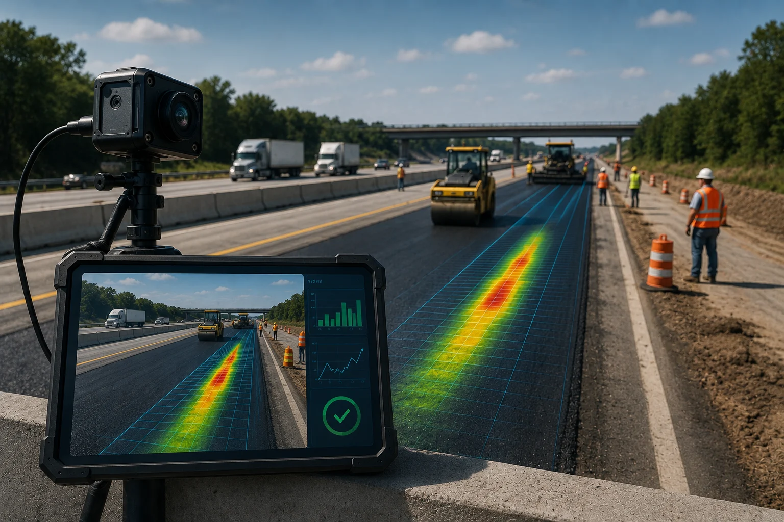
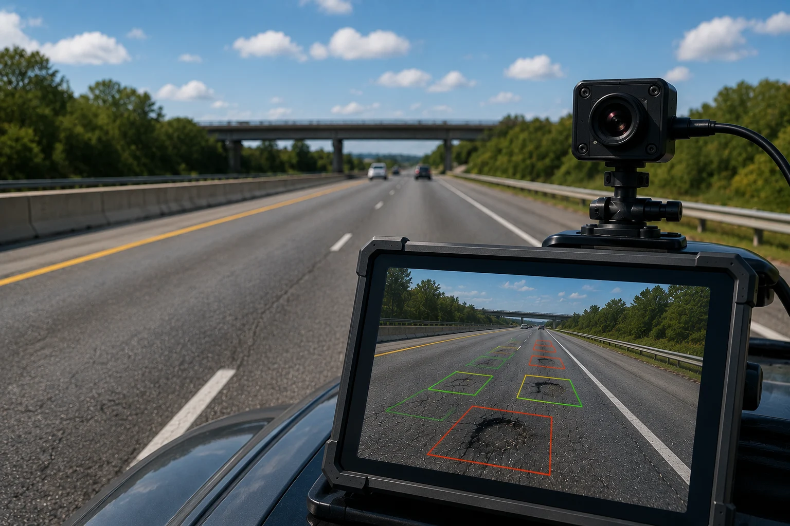
Artificial intelligence, particularly computer vision and deep learning, has significantly improved the speed, accuracy, and scalability of rutting detection. Here's how AI-based systems typically work:
Vehicles equipped with cameras or smartphones mounted on windshields capture continuous video footage of road surfaces. AI models often convolutional neural networks (CNNs) analyze these frames to detect rutting, cracking, potholes, and other distresses automatically.
High-precision LiDAR sensors capture 3D surface profiles of roads at highway speeds. AI algorithms process this point-cloud data to calculate accurate rut depth measurements across the entire road network, far faster than manual profilometers.
Once distress is detected, machine learning models classify the severity of rutting (low, medium, high) based on depth, width, and length, allowing agencies to prioritize repairs based on risk and urgency.
Beyond detection, AI systems can analyze historical pavement condition data, traffic loads, and climate patterns to predict where rutting is likely to occur before it becomes severe. This shifts road maintenance from reactive to proactive.
AI-detected rutting data is often integrated into Geographic Information Systems (GIS) and pavement management software, giving city planners a real-time, map-based view of road conditions across an entire network.
Despite its advantages, AI-based rutting detection isn't without limitations:
As AI models continue to improve and sensor costs decrease, rutting detection is expected to become increasingly automated and accessible even to smaller municipalities. Emerging trends include:
These advancements point toward a future where road maintenance is largely predictive rather than reactive, reducing both public safety risks and long-term infrastructure costs.
Rutting remains one of the most common and consequential forms of pavement distress, driven by traffic loads, mix design, temperature, and structural weaknesses. While traditional detection methods like profilometers and manual surveys are still valuable, AI-based solutions powered by computer vision, LiDAR, and machine learning are dramatically improving how quickly and accurately rutting can be detected and addressed. For transportation agencies looking to modernize infrastructure management, investing in AI-based pavement monitoring is increasingly becoming not just an option, but a necessity.
Rutting is the formation of longitudinal depressions or channels in the wheel paths of a road surface, caused by repeated traffic loading and pavement deformation over time.
The primary cause is repeated heavy traffic loading combined with factors like poor mix design, high temperatures, and inadequate base support, which weaken the pavement's resistance to deformation.
Rut depth is traditionally measured using a straightedge and rut gauge, or with vehicle-mounted profilometers using lasers or ultrasonic sensors. Most agencies flag rutting for repair once depth exceeds around 10–15 mm.
AI systems use cameras, LiDAR, and machine learning models to analyze road surface images or 3D scans, automatically identifying rutting, measuring its depth, and classifying its severity.

The Autonomous Road Engineer
AI that is transforming road infrastructure, from reactive to predictive.