For most of road engineering history, the only way to know a road's condition was to send someone to look at it. A person, a vehicle, a clipboard, and the willingness to cover every lane kilometre of a network one stretch at a time. This constraint that road knowledge was fundamentally local, manual, and sequential shaped every inspection methodology, every maintenance scheduling cycle, and every asset management system ever built for road infrastructure.
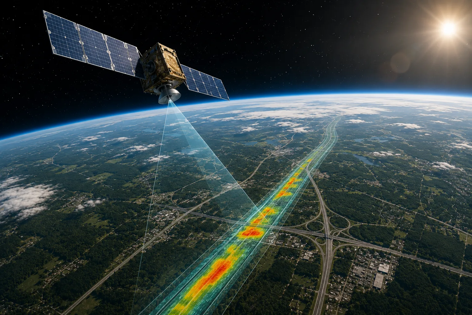
Satellites have always offered a tantalizing alternative: a vantage point from which an entire road network could theoretically be observed in a single pass. But for most of that history, the gap between what satellites could see and what road engineers actually needed to know was too wide to bridge. Images were too coarse to resolve meaningful pavement detail. Revisit frequencies were too low to support operational monitoring. And the analytical tools needed to extract engineering-grade intelligence from satellite imagery simply did not exist at the required scale or accuracy.
In 2025, that gap has closed not completely, and not for every application, but meaningfully enough to make satellite-based road condition monitoring a genuine operational tool rather than a research concept. A convergence of developments has driven this shift: sub-metre resolution commercial satellite constellations now image most of the Earth's landmass daily, advanced satellites like Sentinel-2 deliver images every five days at resolutions up to 10 metres per pixel for broad network screening, and deep learning models trained on large annotated road imagery datasets now extract condition intelligence from satellite data at accuracy levels approaching those of ground-based surveys for appropriate use cases.
High-resolution satellite imagery, combined with AI-powered analytics, can detect congestion patterns, monitor accident hotspots, and identify road hazards such as landslides, floods, or damaged infrastructure enabling governments and traffic management centres to issue early warnings, adjust traffic flows, and prevent potential disasters before they unfold.
RoadVision AI sits at the operational centre of this capability deploying satellite imagery as one layer of a multi-source road intelligence platform that turns remote sensing data into standards-aligned, engineering-grade road condition intelligence across networks of any size, anywhere in the world.
This blog explains what satellite road condition monitoring can and cannot do in 2025, where it fits within a broader multi-source monitoring strategy, and what RoadVision AI's platform delivers on top of the raw satellite data.
Understanding what is possible requires first understanding what has changed in the satellite imagery ecosystem over the past several years because the technology that underpins 2025's capabilities is significantly different from what existed even five years ago.
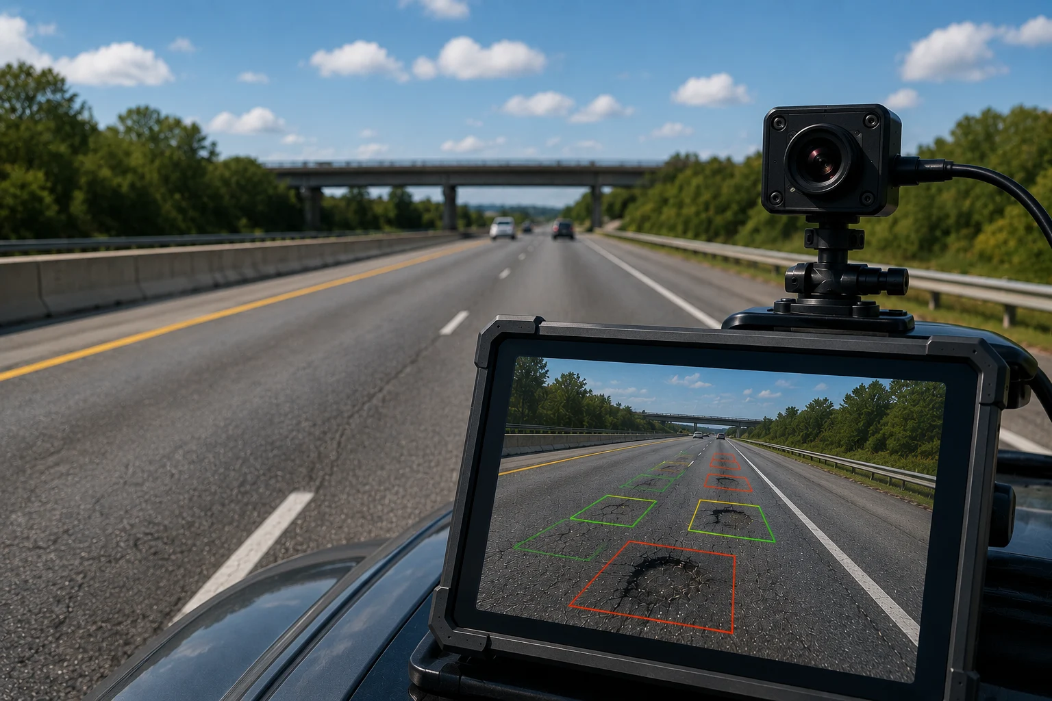
The commercial satellite imagery market has matured dramatically. Where the early generations of commercial earth observation satellites delivered imagery at two to three metre resolution adequate for land use classification but too coarse for road surface detail current commercial constellations now routinely offer imagery at 30 to 50 centimetre resolution. At this resolution, lane-level road features become clearly visible, pavement surface texture becomes discernible, and larger road defects significant pothole clusters, severe surface degradation, major cracking patterns become detectable by trained AI models.
This does not mean satellite imagery has replaced ground-level camera systems for granular defect detection. A 30-centimetre satellite pixel still cannot resolve a 3-millimetre surface crack that a vehicle-mounted camera would capture in high-resolution close-up. But it does mean that satellite imagery now carries genuine diagnostic value for network-level condition classification, change detection, and priority screening applications that did not exist at operational scale before this resolution threshold was crossed.
Early commercial satellite operators offered revisit cycles measured in weeks useful for slow-changing phenomena like seasonal vegetation patterns, deeply inadequate for monitoring infrastructure that can develop significant new damage following a single weather event. The proliferation of commercial small satellite constellations has compressed revisit cycles dramatically. Major commercial providers now offer sub-daily revisit capability for priority areas, and daily coverage for most of the world's road network is now commercially accessible at reasonable cost.
For road monitoring applications, daily or near-daily revisit unlocks change detection the ability to compare current imagery against a baseline to identify where conditions have changed, rather than assessing absolute condition from a single image. Change detection is particularly powerful for post-event damage assessment, construction progress monitoring, and identifying road segments that have deteriorated rapidly following extreme weather.
The third change is the analytical layer that transforms raw satellite pixels into engineering-relevant information.Coupled with AI particularly Convolutional Neural Networks (CNN) satellite data can identify road conditions accurately without the immediate need for on-site surveys.<
Researchers have also applied image enhancement techniques such as super-resolution, using deep-learning methods like Real-ESRGAN to upscale lower-resolution satellite images into detailed visuals more suitable for accurate analysis.While super-resolution does not uniformly improve all detection applications, it demonstrates the extent to which AI is being used to push the informational content of satellite imagery beyond what the raw pixels alone contain.
What this means in practice is that 2025's satellite road monitoring is not simply a matter of human experts looking at sharper images it is a pipeline in which AI models trained on large annotated road datasets process imagery automatically, classify condition states, detect changes, and produce structured outputs that can feed directly into asset management and engineering decision workflows.
With this context established, here is a grounded picture of what satellite-based road condition monitoring is actually capable of delivering as an operational tool in 2025 and where its genuine limitations lie.
Satellite imagery is highly effective for network-level condition screening classifying road segments into broad condition bands (good, moderate, poor, urgent) across large networks quickly and at far lower cost per kilometre than ground survey methods.
RoadVision AI offers clear, user-friendly road condition maps, similar to Google Maps, with road conditions categorised into good, average, or requiring urgent attention based on satellite imagery. These maps are tailored for infrastructure management — to be used by road authorities, municipal bodies, smart city administrators, and highway operators to support maintenance and safety efforts.
This screening capability is most valuable precisely where it is hardest to achieve through ground surveys: large, geographically dispersed networks in which comprehensive field coverage within a single inspection cycle is operationally impossible. TRL's solution demonstrates that the machine learning assessments performed by AI on satellite imagery are more rapid and consistent than manual assessments, enabling roads to be prioritised for further inspection or treatment across entire networks.
For road authorities managing tens of thousands of kilometres of mixed-quality road, satellite-derived condition maps enable a triage approach concentrating expensive ground survey resources on the segments identified from above as most likely to need attention, rather than systematically covering every kilometre at uniform cost regardless of likely condition.
One of the most powerful and well-validated applications of satellite road monitoring is rapid damage assessment following natural disasters or extreme weather events. Rapid Road Damage Assessment Agent uses satellite imagery and AI to rapidly assess post-disaster road damage, giving emergency response and reconstruction planning teams a fast, network-wide damage picture within hours of an event rather than the days or weeks that ground-based damage surveys require.
The value of this capability in disaster contexts is difficult to overstate. When roads are cut off, flooded, or collapsed following a flood, earthquake, or landslide event, the first question for emergency responders is always: which routes are passable, which are not, and where is damage most severe? Satellite change detection comparing pre-event and post-event imagery across the full affected network can answer those questions at network scale within hours of usable post-event imagery becoming available, guiding the deployment of limited emergency crews to the locations of greatest need rather than requiring them to discover blockages by driving into them.
Real-time satellite monitoring can identify road hazards such as landslides, floods, or damaged infrastructure, enabling governments and traffic management centres to issue early warnings and coordinate relief efforts when ground-based data sources may be unreliable or unavailable.
Satellite imagery's ability to cover large areas repeatedly from a fixed overhead perspective makes it well suited to construction progress monitoring — tracking how a road project evolves from a baseline state through earthworks, base course, and final surface, and comparing actual progress against scheduled milestones.
RoadVision AI's Construction Monitoring Agent uses satellite imagery alongside other data sources to autonomously monitor project progress, quality, and compliance across construction stages giving project owners and consultants continuous visibility into whether a project is advancing at the rate and quality the contract requires, without needing to schedule and staff frequent site visits to every active work zone.
The corridor around a road its embankments, medians, drainage channels, and surrounding land — changes continuously, and those changes have direct implications for road safety and infrastructure integrity. Vegetation encroaching on sightlines creates accident risk. Embankment erosion threatens structural stability. Adjacent land use changes alter drainage patterns that affect pavement performance.
RoadVision AI's Road Vegetation Analysis Agent monitors roadside vegetation for safety and green highway compliance using dashcam and satellite data</cite flagging encroachment that exceeds safe limits before it becomes a crash factor. Satellite imagery is particularly well suited to this application because the relevant changes occur at a spatial scale tens to hundreds of metres that satellite resolution can resolve clearly, and on a temporal scale seasonal growth cycles that matches typical satellite revisit frequencies.
Satellite-based vehicle detection enables analysis of bottlenecks, route efficiency, and fleet deployment across entire regions. Unlike ground-based sensors or GPS tracking, which can be limited in coverage, satellite imagery offers a comprehensive view of traffic conditions across entire regions.
For road authorities undertaking origin-destination studies, traffic volume estimation on remote roads without ground-based counting infrastructure, or regional freight movement analysis, satellite-derived traffic data fills a monitoring gap that traditional sensors cannot economically cover.
Honest assessment of satellite road condition monitoring in 2025 requires being equally clear about its limitations because overstating satellite capability leads to misconfigured monitoring programs that miss the defects they were designed to catch.
Granular surface defect detection remains a ground-level capability. A sub-metre satellite pixel cannot resolve an individual pothole smaller than a few square metres, cannot measure crack width at the millimetre level required for pavement condition index scoring, cannot assess retroreflectivity of road markings, and cannot capture the geometric depth and volume measurements that characterize structural pavement distress. For these applications, vehicle-mounted cameras operating at close range and where precision demands it, LiDAR remain the necessary data source.
Cloud cover and weather limit availability. Optical satellite imagery is blocked by cloud cover, which is particularly significant in tropical regions and during monsoon seasons. Radar-based satellite sensors can penetrate cloud cover but provide different and typically lower-resolution information than optical imagery for road surface applications.
Temporal resolution limits real-time monitoring. Even with improved revisit frequencies, satellite imagery is not a continuous data stream it is a sequence of snapshots. For applications requiring real-time or near-real-time monitoring live traffic conditions, immediate incident detection, active construction quality control — ground-based sensor systems remain essential.
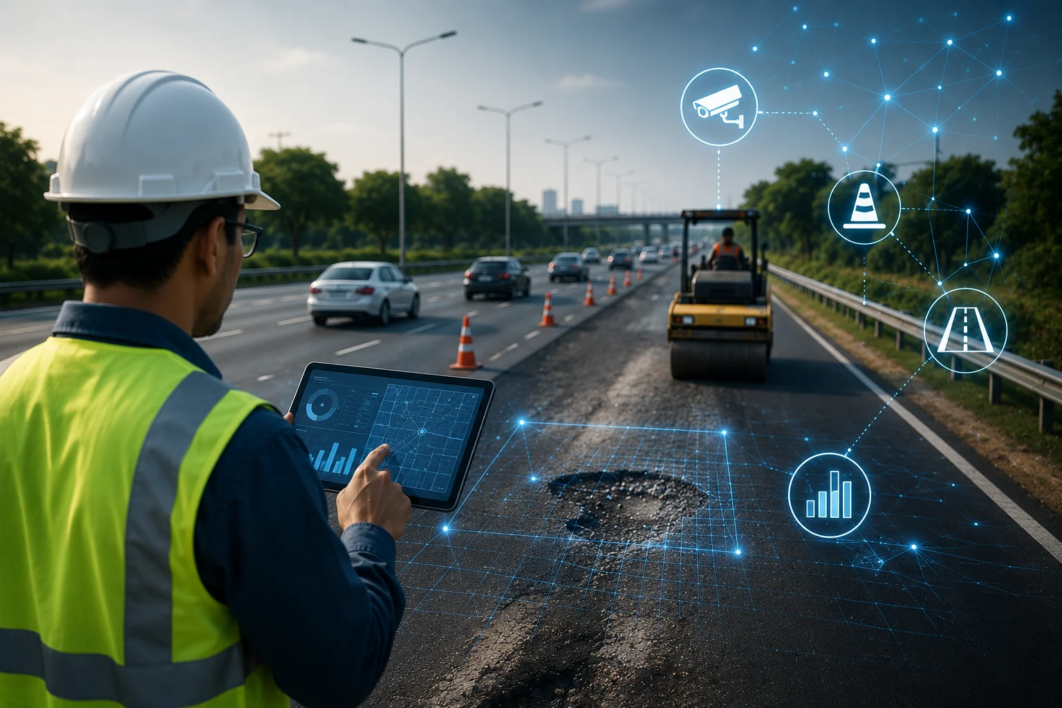
This is precisely why >RoadVision AI uses satellite imagery from UP42, a marketplace for earth observation data, to obtain a broad overview of road networks and flag sections that need attention, while also using a smartphone-based app mounted on vehicles, dashcams, survey vehicles, and drones to capture geotagged videos and related data as part of road surveys.
The architecture is deliberate: satellite provides the broad, frequent, low-cost network overview that identifies where ground resources need to go; vehicle-mounted cameras provide the granular, close-range defect detail that satellite resolution cannot deliver; drones provide targeted high-resolution coverage of specific assets or locations requiring detailed inspection. Each data source does what it does best, and RoadGPT processes all of them through a single analytical pipeline.
<cite index="13-1">RoadVision AI obtains satellite imagery from UP42, a marketplace for earth observation data, to obtain a broad overview of road networks and flag sections that need attention.</cite> UP42's marketplace aggregates imagery from multiple commercial satellite operators, enabling RoadVision AI to source imagery at the resolution, revisit frequency, and geographic coverage most appropriate for each client's monitoring requirements — rather than being constrained to a single satellite provider's coverage and pricing.
This marketplace approach also means that as new commercial satellite constellations come online and improve the resolution and revisit options available, RoadVision AI's platform can incorporate those improvements without requiring architectural changes the data sourcing layer remains flexible as the satellite ecosystem evolves.
Raw satellite imagery is processed by RoadGPT, RoadVision AI's core AI engine, which applies deep learning models trained on annotated road condition imagery to extract condition classifications, change detections, and asset inventory data from satellite inputs.
Critically, this processing is standards-aware — outputs are evaluated against IRC, MoRTH, ASTM, AASHTO, and other applicable engineering codes rather than against generic thresholds. A road segment flagged as "poor" in RoadVision AI's satellite analysis reflects a condition assessment grounded in the engineering standard applicable to that road type and jurisdiction, not a relative score with no regulatory reference point.
<cite index="13-1">The platform claims to deliver insights with over 95% accuracy, validated by pilot projects across several countries.</cite>
<cite index="13-1">Road conditions are categorised into good, average, or requiring urgent attention, based on satellite imagery. The colour-coded dashboard interprets road infrastructure conditions for road authorities, municipal bodies, smart city administrators, and highway operators to support maintenance and safety efforts.</cite>
The deliberately familiar Google Maps-style presentation reduces the barrier to adoption for road authority staff who may not have specialist data science skills — condition intelligence is immediately accessible to maintenance planners and asset managers without requiring training in geospatial software or remote sensing methodology.
Satellite-derived condition data flows into RoadVision AI's broader dashboard alongside dashcam and drone inputs, creating a unified condition map in which each section of network is annotated with the best available data from whichever source has most recently covered it. This integrated view feeds directly into the platform's priority work list generation, predictive maintenance scheduling, and automated reporting outputs ensuring that satellite intelligence translates into concrete maintenance decisions and contractor work orders rather than remaining as maps that require further manual analysis to act on.
Emerging Markets and Developing Road Networks Poorly maintained rural roads limit economic development, perpetuate poverty, and limit the physical and social health of communities. TRL's satellite-based solution enables a step-change from the status quo of low-data, low-technology management of unpaved roads to a data-driven system that makes better use of financial and physical resources.</cite> RoadVision AI's platform extends this capability to paved and semi-paved networks in emerging markets, where field inspection capacity is typically the most constrained relative to network size.
Large National Highway Networks For national road agencies responsible for networks spanning hundreds of thousands of kilometres common across India, the Middle East, Africa, and Latin America comprehensive ground survey coverage on annual cycles is operationally impossible at realistic budget levels. Satellite-based network screening identifies priority corridors for targeted ground survey investment, enabling rational prioritization of limited field resources across the full network.
Post-Disaster Emergency Response RoadVision AI's Rapid Road Damage Assessment Agent has direct application for national disaster management authorities, international development agencies, and humanitarian logistics organizations any entity that needs to rapidly understand network accessibility following a flood, earthquake, cyclone, or conflict-related infrastructure damage event.
Construction Project Oversight International development institutions, project financing agencies, and construction concession owners use satellite-based progress monitoring to maintain independent, objective visibility into the pace and spatial extent of construction activity on road projects without depending solely on contractor-reported progress data.
Smart City Road Management<cit= RoadVision AI is capable of monitoring entire road networks efficiently, making it ideal for smart city AI solutions, enabling planners and engineers to make informed decisions using real-time and historical analytics.= Municipal corporations integrating road condition intelligence into smart city operational dashboards use satellite-derived condition maps as the network-scale layer that contextualizes the more granular data captured by vehicle-mounted and fixed ground sensors.
The capabilities described in this blog represent the state of satellite road monitoring in 2025 already substantially more capable than five years ago, but continuing to evolve. Several developments are likely to further expand what is possible in the near term.
Higher-resolution commercial imagery. Commercial satellite operators are continuing to push spatial resolution into the 10–25 centimetre range for commercial applications. As sub-25 centimetre imagery becomes more widely accessible and competitively priced, the range of pavement defects detectable from orbit will expand, narrowing the gap between satellite and ground-level detection capability for larger defect classes.
More frequent and affordable revisits. Expanding small satellite constellations are making sub-daily revisit cycles commercially practical for infrastructure monitoring applications, enabling truly continuous change detection rather than periodic snapshot comparison.
SAR integration for all-weather monitoring. Synthetic aperture radar (SAR) satellite data is not affected by cloud cover or darkness, and AI processing of SAR data for road surface change detection is an active research and development area. SAR integration will extend the operational reliability of satellite road monitoring in regions where optical imagery availability is frequently limited by weather.
Tighter integration with ground sensor networks. The most capable road monitoring systems of the next five years will fuse satellite imagery with IoT ground sensor data, vehicle probe data, and AI-processed dashcam feeds in real time creating a continuously updated, multi-source road condition picture in which each data layer compensates for the others' limitations.
Satellite road condition monitoring in 2025 is not a future capability or a research prototype it is an operational tool that road authorities, emergency response agencies, development institutions, and infrastructure investors are using right now to gain network-level intelligence that ground survey programs alone cannot deliver at the required scale, speed, or cost.
What has made 2025 different from previous years is the convergence of three things: satellite imagery with sufficient resolution to carry genuine road diagnostic value, AI models capable of extracting standards-aligned engineering intelligence from that imagery automatically, and a multi-source platform architecture that combines satellite's broad coverage with ground-level systems' precision so that the limitations of each are compensated by the strengths of the others.
RoadVision AI delivers exactly that convergence sourcing satellite imagery through the UP42 earth observation marketplace, processing it through RoadGPT against 50-plus engineering standards, presenting findings through accessible colour-coded condition maps, and integrating satellite intelligence seamlessly with dashcam and drone data in a unified platform that delivers engineering-grade road condition intelligence at network scale, anywhere in the world.
The view from above has never been more informative or more actionable.
Want to see what satellite intelligence looks like for your road network? Contact RoadVision AI today to explore how multi-source monitoring can give your team the network-wide visibility that ground surveys alone cannot provide.
At current commercial resolution levels of 30–50 centimetres, satellite imagery can support network-level condition classification (good, moderate, poor), detection of significant surface degradation, large cracking patterns, and substantial deformation over areas of several square metres or more. It is highly effective for change detection — identifying where conditions have changed between image acquisitions — and for vegetation encroachment monitoring. Individual small cracks, pothole depth measurement, and retroreflectivity assessment remain ground-level camera or LiDAR applications.
Q2: How does RoadVision AI source its satellite imagery?RoadVision AI sources satellite imagery through UP42, an earth observation data marketplace that aggregates imagery from multiple commercial satellite operators. This approach allows the platform to access imagery at the resolution, revisit frequency, and geographic coverage most appropriate for each deployment, rather than being locked into a single provider's specifications and pricing.
Q3: How often can a road network be monitored using satellite imagery?Revisit frequency depends on the satellite constellations and imagery tiers selected. Broad network screening imagery from providers like Sentinel-2 is available every five days. High-resolution commercial imagery is available at daily or sub-daily revisit for most locations at a cost premium. RoadVision AI configures monitoring frequency to match each client's operational requirements and budget — with post-disaster applications using highest-frequency imagery and routine network screening typically using lower-frequency, lower-cost options.
Q4: How accurate is satellite-based road condition assessment?RoadVision AI's platform delivers insights with over 95% accuracy for network-level condition classification, validated by pilot projects across multiple countries. For applications requiring defect-level precision — individual pothole detection, crack width measurement, structural distress assessment — the platform combines satellite inputs with vehicle-mounted camera data to achieve the granularity and accuracy required.

The Autonomous Road Engineer
AI that is transforming road infrastructure, from reactive to predictive.